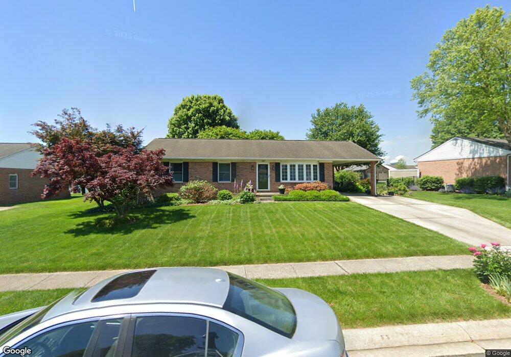
717 Huntington Way Bel Air, MD 21015
Estimated Value: $369,598 - $433,000
--
Bed
1
Bath
1,334
Sq Ft
$308/Sq Ft
Est. Value
About This Home
This home is located at 717 Huntington Way, Bel Air, MD 21015 and is currently estimated at $411,400, approximately $308 per square foot. 717 Huntington Way is a home located in Harford County with nearby schools including Fountain Green Elementary School, Southampton Middle School, and C. Milton Wright High School.
Ownership History
Date
Name
Owned For
Owner Type
Purchase Details
Closed on
Aug 22, 2003
Sold by
Falk Karen M
Bought by
Rayboen David and Rayboen Ann
Current Estimated Value
Purchase Details
Closed on
Jun 24, 1998
Sold by
Falk Robert B
Bought by
Falk Karen M
Purchase Details
Closed on
Nov 4, 1988
Sold by
Greenridge Development Corporation
Bought by
Falk Robert B
Home Financials for this Owner
Home Financials are based on the most recent Mortgage that was taken out on this home.
Original Mortgage
$97,000
Interest Rate
10.12%
Create a Home Valuation Report for This Property
The Home Valuation Report is an in-depth analysis detailing your home's value as well as a comparison with similar homes in the area
Home Values in the Area
Average Home Value in this Area
Purchase History
| Date | Buyer | Sale Price | Title Company |
|---|---|---|---|
| Rayboen David | $200,000 | -- | |
| Falk Karen M | -- | -- | |
| Falk Robert B | $108,000 | -- |
Source: Public Records
Mortgage History
| Date | Status | Borrower | Loan Amount |
|---|---|---|---|
| Previous Owner | Falk Robert B | $97,000 | |
| Closed | Falk Karen M | -- |
Source: Public Records
Tax History Compared to Growth
Tax History
| Year | Tax Paid | Tax Assessment Tax Assessment Total Assessment is a certain percentage of the fair market value that is determined by local assessors to be the total taxable value of land and additions on the property. | Land | Improvement |
|---|---|---|---|---|
| 2025 | $3,148 | $303,500 | $98,200 | $205,300 |
| 2024 | $3,148 | $289,633 | $0 | $0 |
| 2023 | $2,998 | $275,767 | $0 | $0 |
| 2022 | $2,854 | $261,900 | $98,200 | $163,700 |
| 2021 | $2,876 | $255,567 | $0 | $0 |
| 2020 | $2,876 | $249,233 | $0 | $0 |
| 2019 | $2,803 | $242,900 | $112,800 | $130,100 |
| 2018 | $2,716 | $237,533 | $0 | $0 |
| 2017 | $2,655 | $242,900 | $0 | $0 |
| 2016 | -- | $226,800 | $0 | $0 |
| 2015 | $2,563 | $224,900 | $0 | $0 |
| 2014 | $2,563 | $223,000 | $0 | $0 |
Source: Public Records
Map
Nearby Homes
- 1622 Shady Tree Ct
- 1620 Shady Tree Ct
- 1618 Shady Tree Ct
- 1619 Shady Tree Ct
- 1614 Shady Tree Ct
- 1617 Shady Tree Ct
- 1612 Shady Tree Ct
- 1613 Shady Tree Ct
- 1609 Shady Tree Ct
- 1607 Shady Tree Ct
- 1605 Shady Tree Ct
- Yorktown Plan at Roberts Crossing
- Coronado Plan at Roberts Crossing
- Hemingway Plan at Roberts Crossing
- 602 Flintlock Dr
- 1441 Valbrook Ct N
- 1505 Southview Rd
- 1453 Redfield Rd
- 1358 Merry Hill Ct
- 1313 Kelsey Ct
- 715 Huntington Way
- 719 Huntington Way
- 1708 Berdan Ct
- 713 Huntington Way
- 721 Huntington Way
- 1709 Berdan Ct
- 708 Huntington Way
- 1701 Stephens Place
- 710 Huntington Way
- 1711 Allen Ct
- 1706 Berdan Ct
- 711 Huntington Way
- 1700 Stephens Place
- 1707 Berdan Ct
- 1710 Allen Ct
- 820 Flintlock Dr
- 712 Huntington Way
- 1703 Stephens Place
- 1709 Allen Ct
- 824 Flintlock Dr