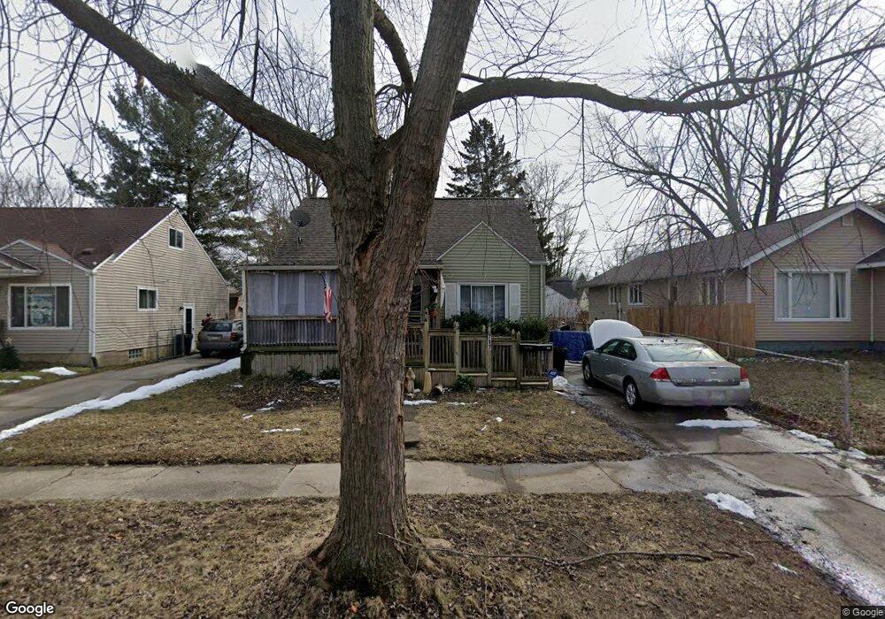
717 Leland St Flint, MI 48507
South Side NeighborhoodEstimated Value: $46,000 - $74,000
3
Beds
1
Bath
924
Sq Ft
$67/Sq Ft
Est. Value
About This Home
This home is located at 717 Leland St, Flint, MI 48507 and is currently estimated at $61,911, approximately $67 per square foot. 717 Leland St is a home located in Genesee County with nearby schools including Neithercut Elementary School, Flint Southwestern Classical Academy, and International Academy of Flint (K-12).
Ownership History
Date
Name
Owned For
Owner Type
Purchase Details
Closed on
Jun 28, 2024
Sold by
Winter Michael L and Earls Betty J
Bought by
Mason Bradley O
Current Estimated Value
Purchase Details
Closed on
May 22, 2024
Sold by
Hohn Lanny D and Hohn Rose M
Bought by
Winter Michael L and Earls Betty J
Purchase Details
Closed on
Nov 19, 2018
Sold by
Courser Lori J and Hohn Cynthia A
Bought by
Hohn Lanny D and Hohn Rose M
Purchase Details
Closed on
Nov 22, 2011
Sold by
Hohn Jerome J and Hohn June G
Bought by
Hohn Jerome J and Hohn June G
Create a Home Valuation Report for This Property
The Home Valuation Report is an in-depth analysis detailing your home's value as well as a comparison with similar homes in the area
Home Values in the Area
Average Home Value in this Area
Purchase History
| Date | Buyer | Sale Price | Title Company |
|---|---|---|---|
| Mason Bradley O | -- | None Listed On Document | |
| Winter Michael L | $5,000 | None Listed On Document | |
| Hohn Lanny D | $15,000 | None Available | |
| Hohn Jerome J | -- | None Available |
Source: Public Records
Tax History
| Year | Tax Paid | Tax Assessment Tax Assessment Total Assessment is a certain percentage of the fair market value that is determined by local assessors to be the total taxable value of land and additions on the property. | Land | Improvement |
|---|---|---|---|---|
| 2025 | $1,066 | $24,200 | $0 | $0 |
| 2024 | $989 | $22,100 | $0 | $0 |
| 2023 | $968 | $16,700 | $0 | $0 |
| 2022 | $0 | $15,500 | $0 | $0 |
| 2021 | $980 | $13,500 | $0 | $0 |
| 2020 | $903 | $12,700 | $0 | $0 |
| 2019 | $885 | $10,600 | $0 | $0 |
| 2018 | $701 | $9,300 | $0 | $0 |
| 2017 | $732 | $0 | $0 | $0 |
| 2016 | $727 | $0 | $0 | $0 |
| 2015 | -- | $0 | $0 | $0 |
| 2014 | -- | $0 | $0 | $0 |
| 2012 | -- | $13,500 | $0 | $0 |
Source: Public Records
Map
Nearby Homes
- 652 Crawford St
- 806 Alvord Ave
- 805 Alvord Ave
- 822 Campbell St
- 612 Clinton St
- 845 Alvord Ave
- 829 Clinton St
- 3902 Brunswick Ave
- 912 Huron St
- 3902 Cuthbertson St
- 805 Vermilya Ave
- 825 Vermilya Ave
- 1028 Campbell St
- 1015 Alvord Ave
- 3214 S Grand Traverse St
- 1216 E Hemphill Rd
- 615 Freeman Ave
- 846 W Hemphill Rd
- 855 Victoria Ave
- 1130 W Atherton Rd
Your Personal Tour Guide
Ask me questions while you tour the home.