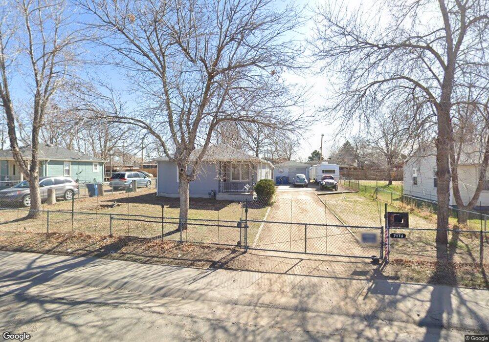
7176 Newport St Commerce City, CO 80022
Kemp NeighborhoodEstimated Value: $342,836 - $375,000
2
Beds
1
Bath
976
Sq Ft
$373/Sq Ft
Est. Value
About This Home
This home is located at 7176 Newport St, Commerce City, CO 80022 and is currently estimated at $363,709, approximately $372 per square foot. 7176 Newport St is a home located in Adams County with nearby schools including Kemp Elementary School, Kearney Middle School, and Adams City High School.
Ownership History
Date
Name
Owned For
Owner Type
Purchase Details
Closed on
Nov 26, 2001
Sold by
Belt Lloyd W
Bought by
Kaczar Daniel R and Kaczar Kathleen M
Current Estimated Value
Home Financials for this Owner
Home Financials are based on the most recent Mortgage that was taken out on this home.
Original Mortgage
$125,100
Outstanding Balance
$48,774
Interest Rate
6.54%
Estimated Equity
$314,935
Create a Home Valuation Report for This Property
The Home Valuation Report is an in-depth analysis detailing your home's value as well as a comparison with similar homes in the area
Home Values in the Area
Average Home Value in this Area
Purchase History
| Date | Buyer | Sale Price | Title Company |
|---|---|---|---|
| Kaczar Daniel R | $139,000 | Security Title |
Source: Public Records
Mortgage History
| Date | Status | Borrower | Loan Amount |
|---|---|---|---|
| Open | Kaczar Daniel R | $125,100 |
Source: Public Records
Tax History Compared to Growth
Tax History
| Year | Tax Paid | Tax Assessment Tax Assessment Total Assessment is a certain percentage of the fair market value that is determined by local assessors to be the total taxable value of land and additions on the property. | Land | Improvement |
|---|---|---|---|---|
| 2024 | $2,014 | $21,370 | $5,310 | $16,060 |
| 2023 | $1,772 | $24,080 | $5,750 | $18,330 |
| 2022 | $1,674 | $18,630 | $5,770 | $12,860 |
| 2021 | $1,698 | $18,630 | $5,770 | $12,860 |
| 2020 | $1,530 | $16,980 | $5,010 | $11,970 |
| 2019 | $1,527 | $16,980 | $5,010 | $11,970 |
| 2018 | $1,259 | $13,640 | $4,460 | $9,180 |
| 2017 | $1,196 | $13,640 | $4,460 | $9,180 |
| 2016 | $858 | $9,470 | $2,230 | $7,240 |
| 2015 | $876 | $9,470 | $2,230 | $7,240 |
| 2014 | -- | $7,540 | $1,830 | $5,710 |
Source: Public Records
Map
Nearby Homes
- 7131 Pontiac St
- 6601 E 71st Ave
- 6980 Niagara St
- 7165 E 72nd Place
- 6641 E 73rd Place
- 7075 Garden Ln
- 7050 Kearney Ct
- 0 Lot 2 Unit REC2976963
- 7461 Locust St
- 6420 E 68th Ave
- 7560 Monaco St
- 6751 Leyden St
- 7561 Leyden St Unit 3A
- 7571 Leyden St
- 7560 Krameria St
- 6721 Leyden St
- 6001 E 74th Ave
- 6711 Leyden St
- 5971 E 69th Ave
- 5971 E 69th Ave Unit 21
- 7174 Newport St
- 7180 Newport St
- 7140 Newport St
- 7190 Newport St
- 7171 Olive St
- 7161 Olive St
- 7181 Olive St
- 7151 Olive St
- 7100 Newport St
- 7145 Newport St
- 7161 Newport St
- 7191 Olive St
- 6800 E 72nd Ave
- 7141 Olive St
- 7141 Newport St
- 7181 Newport St
- 7185 Newport St
- 7131 Olive St
- 7111 Newport St
- 7121 Olive St