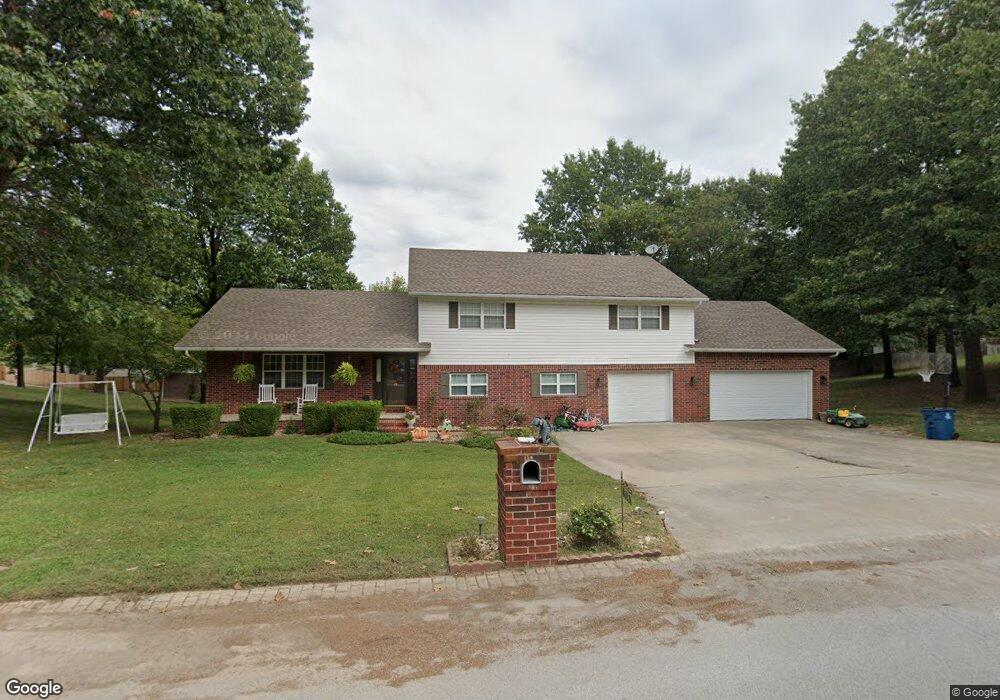
718 Laurel Cir Neosho, MO 64850
Estimated Value: $302,000 - $402,000
4
Beds
3
Baths
2,850
Sq Ft
$123/Sq Ft
Est. Value
About This Home
This home is located at 718 Laurel Cir, Neosho, MO 64850 and is currently estimated at $351,849, approximately $123 per square foot. 718 Laurel Cir is a home located in Newton County with nearby schools including Neosho High School, Ozark Christian Academy, and Neosho Christian Schools.
Ownership History
Date
Name
Owned For
Owner Type
Purchase Details
Closed on
Aug 6, 2018
Sold by
Wade Scott E and Wade Christina L
Bought by
Hernandez Kayla R and Hernandez Jorge L
Current Estimated Value
Home Financials for this Owner
Home Financials are based on the most recent Mortgage that was taken out on this home.
Original Mortgage
$214,051
Outstanding Balance
$185,895
Interest Rate
4.5%
Mortgage Type
FHA
Estimated Equity
$165,954
Purchase Details
Closed on
Apr 23, 2018
Sold by
Wade Scott E
Bought by
Wade Family Trust
Create a Home Valuation Report for This Property
The Home Valuation Report is an in-depth analysis detailing your home's value as well as a comparison with similar homes in the area
Home Values in the Area
Average Home Value in this Area
Purchase History
| Date | Buyer | Sale Price | Title Company |
|---|---|---|---|
| Hernandez Kayla R | $216,191 | None Listed On Document | |
| Wade Family Trust | -- | None Listed On Document |
Source: Public Records
Mortgage History
| Date | Status | Borrower | Loan Amount |
|---|---|---|---|
| Open | Hernandez Kayla R | $214,051 |
Source: Public Records
Tax History
| Year | Tax Paid | Tax Assessment Tax Assessment Total Assessment is a certain percentage of the fair market value that is determined by local assessors to be the total taxable value of land and additions on the property. | Land | Improvement |
|---|---|---|---|---|
| 2024 | $1,598 | $29,110 | -- | -- |
| 2023 | $1,598 | $29,110 | $3,762 | $25,348 |
| 2022 | $1,598 | $28,460 | -- | -- |
| 2021 | $1,561 | $28,460 | $0 | $0 |
| 2020 | $1,528 | $27,970 | $0 | $0 |
| 2019 | $1,392 | $27,970 | $0 | $0 |
| 2018 | $1,336 | $27,970 | $0 | $0 |
| 2017 | $1,321 | $26,620 | $0 | $0 |
| 2016 | $1,321 | $26,330 | $0 | $0 |
| 2015 | -- | $26,220 | $0 | $0 |
| 2014 | -- | $26,220 | $0 | $0 |
Source: Public Records
Map
Nearby Homes
- Tbd W South St
- 512 Geyer Rd
- 620 W South St
- 720 Walnut Dr
- 1706 Watkins Dr
- 1704 Susan Place
- 000 S High St
- Xxx S High
- 2.89 Ac W Daugherty Rd
- 1416 Hawthorne Dr
- 903 S High St
- 1214 Linden Terrace
- 802 S High St
- 1701 Village Ln
- Tbd S Business 49
- 1715 S High St
- 701 S High St
- 521 Oak Ridge Dr
- 620 Archer Ct
- 1026 Sherry Dr
- 706 Laurel Cir
- 805 Laurel Cir
- 716 Laurel Cir
- 704 Mimosa Dr
- 801 Laurel Cir
- 810 Laurel Cir
- 704 Laurel Cir
- 806 Laurel Cir
- 717 Laurel Cir
- 706 Mimosa Dr
- 905 Wornall St
- XX W South St
- 714 Laurel Cir
- 703 Laurel Cir
- 803 W South St
- 807 W South St
- 707 W South St
- 710 Wayne Ave Unit 1
- 710 Wayne Ave
- 705 W South St