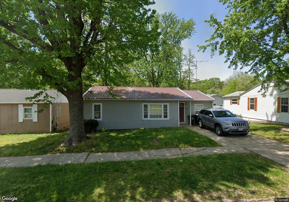
719 N Ault St Moberly, MO 65270
Estimated Value: $86,000 - $158,193
3
Beds
2
Baths
1,036
Sq Ft
$125/Sq Ft
Est. Value
About This Home
This home is located at 719 N Ault St, Moberly, MO 65270 and is currently estimated at $129,798, approximately $125 per square foot. 719 N Ault St is a home located in Randolph County with nearby schools including Moberly Senior High School, St. Pius X. Catholic School, and Maranatha Seventh-day Adventist School.
Ownership History
Date
Name
Owned For
Owner Type
Purchase Details
Closed on
Feb 23, 2023
Sold by
Chilton Michael A and Chilton Amanda L
Bought by
Branson Tanner
Current Estimated Value
Home Financials for this Owner
Home Financials are based on the most recent Mortgage that was taken out on this home.
Original Mortgage
$127,363
Outstanding Balance
$121,380
Interest Rate
4%
Mortgage Type
VA
Estimated Equity
$8,418
Purchase Details
Closed on
Mar 5, 2019
Sold by
Carrington Mortgage Svcs
Bought by
Chilton Michael A and Howard Amanda L
Purchase Details
Closed on
Apr 17, 2007
Sold by
Lucas Properties Llc
Bought by
Chilton Michael A and Howard Amanda L
Home Financials for this Owner
Home Financials are based on the most recent Mortgage that was taken out on this home.
Original Mortgage
$44,500
Interest Rate
6.13%
Create a Home Valuation Report for This Property
The Home Valuation Report is an in-depth analysis detailing your home's value as well as a comparison with similar homes in the area
Home Values in the Area
Average Home Value in this Area
Purchase History
| Date | Buyer | Sale Price | Title Company |
|---|---|---|---|
| Branson Tanner | -- | -- | |
| Chilton Michael A | $44,500 | -- | |
| Chilton Michael A | -- | -- |
Source: Public Records
Mortgage History
| Date | Status | Borrower | Loan Amount |
|---|---|---|---|
| Open | Branson Tanner | $127,363 | |
| Previous Owner | Chilton Michael A | $44,500 |
Source: Public Records
Tax History Compared to Growth
Tax History
| Year | Tax Paid | Tax Assessment Tax Assessment Total Assessment is a certain percentage of the fair market value that is determined by local assessors to be the total taxable value of land and additions on the property. | Land | Improvement |
|---|---|---|---|---|
| 2025 | $603 | $11,150 | $874 | $10,276 |
| 2024 | $603 | $8,280 | $760 | $7,520 |
| 2023 | $612 | $8,280 | $760 | $7,520 |
| 2022 | $557 | $7,740 | $760 | $6,980 |
| 2021 | $587 | $7,740 | $760 | $6,980 |
| 2020 | $587 | $8,160 | $760 | $7,400 |
| 2019 | $586 | $8,160 | $760 | $7,400 |
| 2018 | $573 | $8,000 | $760 | $7,240 |
| 2017 | $572 | $8,000 | $0 | $0 |
| 2016 | $549 | $7,730 | $0 | $0 |
| 2014 | -- | $7,340 | $0 | $0 |
| 2013 | -- | $7,340 | $0 | $0 |
| 2012 | -- | $7,350 | $0 | $0 |
Source: Public Records
Map
Nearby Homes
- 664 & 668 N Ault St
- 812 N Moulton St
- 1102 N Morley St
- 511 Union Ave
- 609 Franklin Ave
- 523 Morehead St
- 625 Franklin Ave
- 602 Vincil St
- 531 Farror St
- 720 Saint Charles St
- 524 Barrow St
- 101 N Ault St
- 620 Burkholder St
- 815 Myra St
- 837 Myra St
- 800 Franklin St
- 1101 Stonebridge Ln
- Lot 11 Stonebridge Lane (Plat 2)
- Lot 10 Stonebridge Lane (Plat 2)