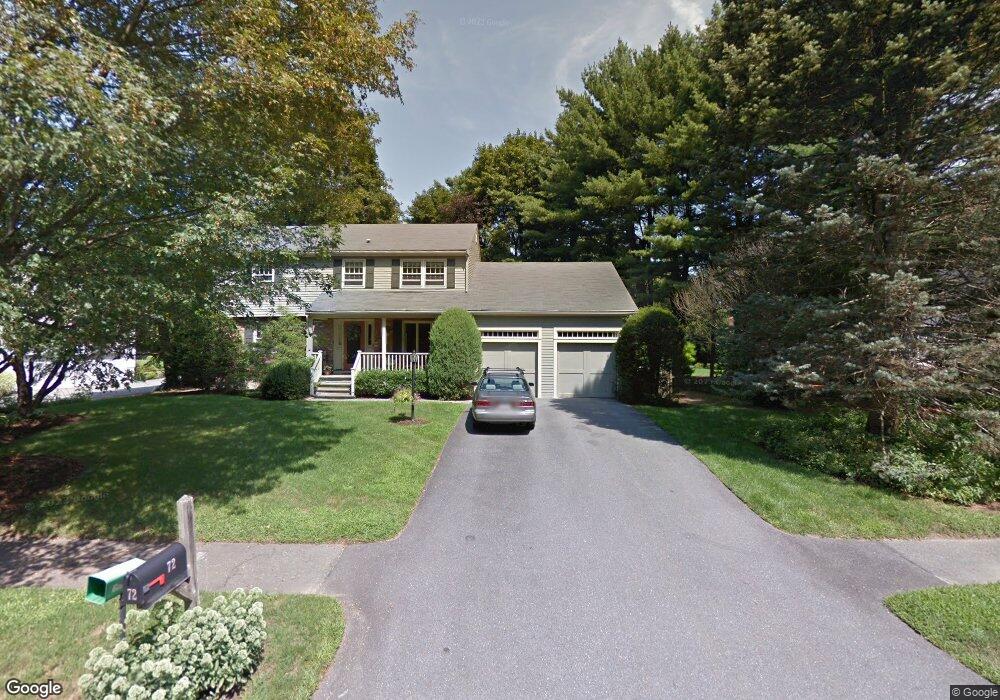
72 Allen Farm Ln Concord, MA 01742
Estimated Value: $1,423,000 - $1,834,000
4
Beds
3
Baths
2,243
Sq Ft
$717/Sq Ft
Est. Value
About This Home
This home is located at 72 Allen Farm Ln, Concord, MA 01742 and is currently estimated at $1,607,552, approximately $716 per square foot. 72 Allen Farm Ln is a home located in Middlesex County with nearby schools including Willard School, Concord Middle School, and Concord Carlisle High School.
Ownership History
Date
Name
Owned For
Owner Type
Purchase Details
Closed on
Apr 29, 2021
Sold by
Fradette James R and Collen Cindy
Bought by
Fradette Collen T
Current Estimated Value
Purchase Details
Closed on
Oct 19, 2004
Sold by
Mcsherry Elisabeth
Bought by
E Mcsherry Rt and Mcsherry Elisabeth M
Purchase Details
Closed on
Jul 30, 1993
Sold by
Lipinski Joseph F and Lipinski Edith M
Bought by
Barash David M and Black Lynn
Create a Home Valuation Report for This Property
The Home Valuation Report is an in-depth analysis detailing your home's value as well as a comparison with similar homes in the area
Home Values in the Area
Average Home Value in this Area
Purchase History
| Date | Buyer | Sale Price | Title Company |
|---|---|---|---|
| Fradette Collen T | -- | None Available | |
| E Mcsherry Rt | -- | -- | |
| Barash David M | $382,000 | -- |
Source: Public Records
Mortgage History
| Date | Status | Borrower | Loan Amount |
|---|---|---|---|
| Previous Owner | Barash David M | $385,000 | |
| Previous Owner | Barash David M | $388,000 |
Source: Public Records
Tax History Compared to Growth
Tax History
| Year | Tax Paid | Tax Assessment Tax Assessment Total Assessment is a certain percentage of the fair market value that is determined by local assessors to be the total taxable value of land and additions on the property. | Land | Improvement |
|---|---|---|---|---|
| 2025 | $168 | $1,269,100 | $630,000 | $639,100 |
| 2024 | $16,663 | $1,269,100 | $630,000 | $639,100 |
| 2023 | $15,312 | $1,181,500 | $572,800 | $608,700 |
| 2022 | $14,261 | $966,200 | $458,200 | $508,000 |
| 2021 | $13,879 | $942,900 | $458,200 | $484,700 |
| 2020 | $13,430 | $943,800 | $458,200 | $485,600 |
| 2019 | $12,785 | $901,000 | $444,800 | $456,200 |
| 2018 | $12,484 | $873,600 | $423,600 | $450,000 |
| 2017 | $12,007 | $853,400 | $403,400 | $450,000 |
| 2016 | $11,327 | $813,700 | $403,400 | $410,300 |
| 2015 | $10,712 | $749,600 | $373,600 | $376,000 |
Source: Public Records
Map
Nearby Homes
- 29 Concord Greene Unit 3
- 24 Concord Greene Unit 7
- 16 Concord Greene Unit 5
- 1053 Main St
- 244 Musterfield Rd
- 602 Main St
- 79-81 Assabet Ave
- 46 Wood St
- 106 Elm St
- 12 S Meadow Ridge Unit 12
- 12 S Meadow Ridge
- 49 Willard Common
- 182 Southfield Rd
- 111 Central St
- 54 Maple St
- 114 Upland Rd
- 102 Highland St
- 22 Belknap Ct
- 70 McCallar Ln
- 232 Sudbury Rd
- 58 Allen Farm Ln
- 86 Allen Farm Ln
- 40 Allen Farm Ln
- 96 Allen Farm Ln
- 73 Allen Farm Ln
- 24 Allen Farm Ln
- 21 Gifford Ln
- 65 Allen Farm Ln
- 83 Allen Farm Ln
- 53 Baker Ave
- 65 Baker Ave
- 95 Allen Farm Ln
- 95 Allen Farm Ln Unit 1
- 61 Allen Farm Ln
- 41 Baker Ave
- 7 Gifford Ln
- 45 Allen Farm Ln
- 43 Gifford Ln
- 41 Allen Farm Ln
- 31 Allen Farm Ln