
Seller's Agent in 2026
Patrick Lydon
USA Real Estate Advisors
(617) 829-9992
1 in this area
28 Total Sales
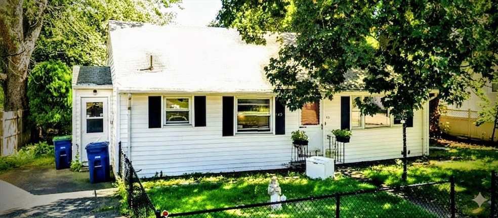
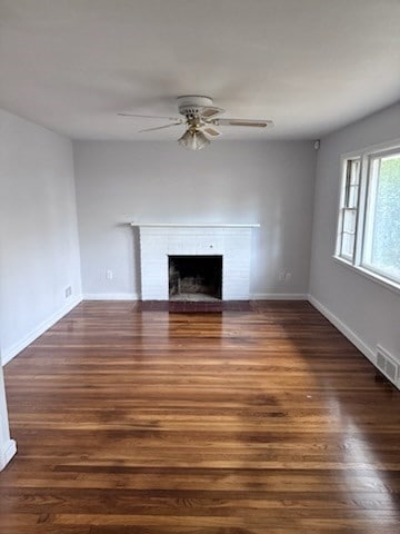
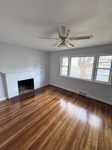
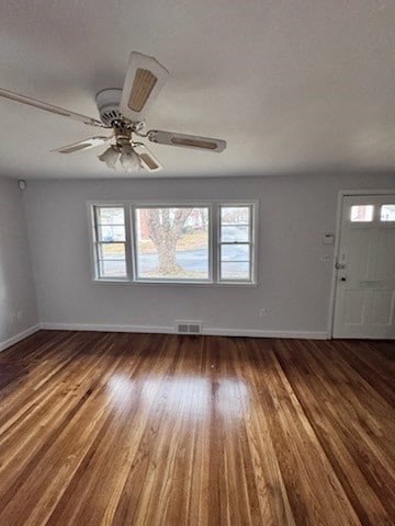
Great Braintree Neighborhood. Home features hardrwood floors, central air and fireplace. Priced for Immediate Sale. EZ to show, all showings must be setup thru showing time. All broker questions via email.
| Date | Type | Sale Price | Title Company |
|---|---|---|---|
| Quit Claim Deed | $570,000 | -- | |
| Quit Claim Deed | -- | None Available | |
| Quit Claim Deed | -- | None Available | |
| Deed | $280,000 | -- | |
| Deed | $280,000 | -- |
| Date | Status | Loan Amount | Loan Type |
|---|---|---|---|
| Open | $529,100 | FHA | |
| Previous Owner | $120,000 | Purchase Money Mortgage |
| Date | Event | Price | List to Sale | Price per Sq Ft |
|---|---|---|---|---|
| 01/29/2026 01/29/26 | Sold | $570,000 | -0.9% | $464 / Sq Ft |
| 12/23/2025 12/23/25 | Pending | -- | -- | -- |
| 12/12/2025 12/12/25 | For Sale | $575,000 | -- | $468 / Sq Ft |
| Year | Tax Paid | Tax Assessment Tax Assessment Total Assessment is a certain percentage of the fair market value that is determined by local assessors to be the total taxable value of land and additions on the property. | Land | Improvement |
|---|---|---|---|---|
| 2025 | $5,150 | $516,000 | $324,500 | $191,500 |
| 2024 | $4,575 | $482,600 | $294,600 | $188,000 |
| 2023 | $4,258 | $436,300 | $264,700 | $171,600 |
| 2022 | $4,086 | $410,700 | $239,100 | $171,600 |
| 2021 | $3,835 | $385,400 | $216,000 | $169,400 |
| 2020 | $3,607 | $365,800 | $196,400 | $169,400 |
| 2019 | $3,552 | $352,000 | $187,900 | $164,100 |
| 2018 | $3,461 | $328,400 | $170,800 | $157,600 |
| 2017 | $3,328 | $309,900 | $162,200 | $147,700 |
| 2016 | $3,237 | $294,800 | $153,700 | $141,100 |
| 2015 | $2,980 | $269,200 | $128,100 | $141,100 |
| 2014 | $2,802 | $245,400 | $123,000 | $122,400 |
Seller's Agent in 2026
Patrick Lydon
USA Real Estate Advisors
(617) 829-9992
1 in this area
28 Total Sales
Buyer's Agent in 2026
Sue Beaudet
eXp Realty
(508) 688-4580
1 in this area
45 Total Sales
Source: MLS Property Information Network (MLS PIN)
MLS Number: 73461992
APN: BRAI-001069-000000-000041
Disclaimer: Certain information contained herein is derived from information provided by parties other than Homes.com. All information provided is deemed reliable, but is not guaranteed to be accurate and should be independently verified.
![]() The property listing data and information, or the Images, set forth herein were provided to MLS Property Information Network, Inc. from third party sources, including sellers, lessors and public records, and were compiled by MLS Property Information Network, Inc. The property listing data and information, and the Images, are for the personal, non-commercial use of consumers having a good faith interest in purchasing or leasing listed properties of the type displayed to them and may not be used for any purpose other than to identify prospective properties which such consumers may have a good faith interest in purchasing or leasing. MLS Property Information Network, Inc. and its subscribers disclaim any and all representations and warranties as to the accuracy of the property listing data and information, or as to the accuracy of any of the Images, set forth herein.
The property listing data and information, or the Images, set forth herein were provided to MLS Property Information Network, Inc. from third party sources, including sellers, lessors and public records, and were compiled by MLS Property Information Network, Inc. The property listing data and information, and the Images, are for the personal, non-commercial use of consumers having a good faith interest in purchasing or leasing listed properties of the type displayed to them and may not be used for any purpose other than to identify prospective properties which such consumers may have a good faith interest in purchasing or leasing. MLS Property Information Network, Inc. and its subscribers disclaim any and all representations and warranties as to the accuracy of the property listing data and information, or as to the accuracy of any of the Images, set forth herein.
Ask me questions while you tour the home.