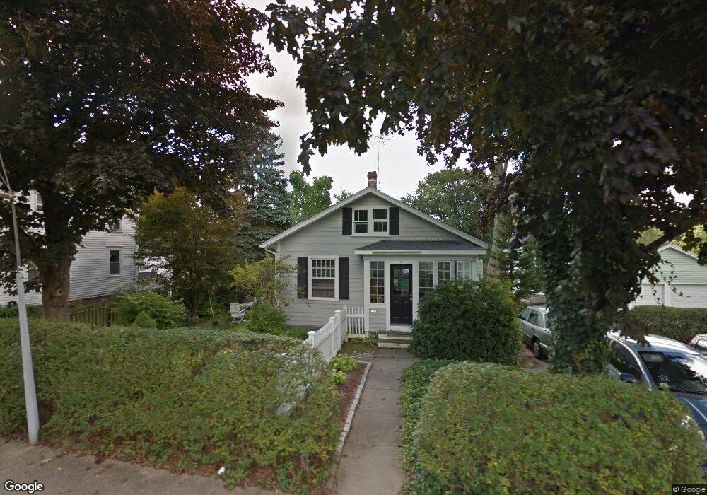
72 High St Amesbury, MA 01913
Estimated Value: $496,927 - $566,000
2
Beds
1
Bath
984
Sq Ft
$544/Sq Ft
Est. Value
About This Home
This home is located at 72 High St, Amesbury, MA 01913 and is currently estimated at $535,732, approximately $544 per square foot. 72 High St is a home located in Essex County with nearby schools including Amesbury High School and Amesbury Seventh-Day Adventist School.
Ownership History
Date
Name
Owned For
Owner Type
Purchase Details
Closed on
Dec 8, 2016
Sold by
Delibertis Roland P
Bought by
Roland P Delibertis Re
Current Estimated Value
Purchase Details
Closed on
Sep 27, 1983
Bought by
Delibertis Roland P
Create a Home Valuation Report for This Property
The Home Valuation Report is an in-depth analysis detailing your home's value as well as a comparison with similar homes in the area
Home Values in the Area
Average Home Value in this Area
Purchase History
| Date | Buyer | Sale Price | Title Company |
|---|---|---|---|
| Roland P Delibertis Re | -- | -- | |
| Delibertis Roland P | $16,000 | -- |
Source: Public Records
Mortgage History
| Date | Status | Borrower | Loan Amount |
|---|---|---|---|
| Previous Owner | Delibertis Roland P | $45,000 | |
| Previous Owner | Delibertis Roland P | $32,000 |
Source: Public Records
Tax History
| Year | Tax Paid | Tax Assessment Tax Assessment Total Assessment is a certain percentage of the fair market value that is determined by local assessors to be the total taxable value of land and additions on the property. | Land | Improvement |
|---|---|---|---|---|
| 2025 | $6,499 | $424,800 | $206,200 | $218,600 |
| 2024 | $6,247 | $399,400 | $194,500 | $204,900 |
| 2023 | $6,111 | $374,000 | $169,100 | $204,900 |
| 2022 | $6,006 | $339,500 | $147,100 | $192,400 |
| 2021 | $5,616 | $307,700 | $113,600 | $194,100 |
| 2020 | $5,023 | $292,400 | $109,200 | $183,200 |
| 2019 | $5,017 | $273,100 | $109,200 | $163,900 |
| 2018 | $5,046 | $265,700 | $104,100 | $161,600 |
| 2017 | $4,618 | $231,500 | $104,100 | $127,400 |
| 2016 | $4,453 | $219,600 | $104,100 | $115,500 |
| 2015 | $4,461 | $217,200 | $104,100 | $113,100 |
| 2014 | $4,192 | $199,900 | $104,100 | $95,800 |
Source: Public Records
Map
Nearby Homes
- 8 Winter St
- 48 Orchard St
- 3 Tremont Ave Unit A
- 27 Lake St
- 4 Clark St
- 19 Maple St Unit 21
- 4 Boardman St
- 101 Market St Unit B
- 25 Cedar St Unit 4
- 97 Elm St
- 1 Hillside Ave Unit 3
- 5 Russell St Unit 1
- 4 Greenwood St
- 149 Market St
- 21 Congress St
- 12 Locke Hill Ln
- 15 Wells Ave
- 21 River St
- 35 Huntington Ave
- 253 Main St
Your Personal Tour Guide
Ask me questions while you tour the home.