
Seller's Agent in 2025
Lisa Sullivan
Insight Realty Group, Inc.
(617) 838-7361
22 in this area
58 Total Sales


Estimated Value: $805,000 - $843,000
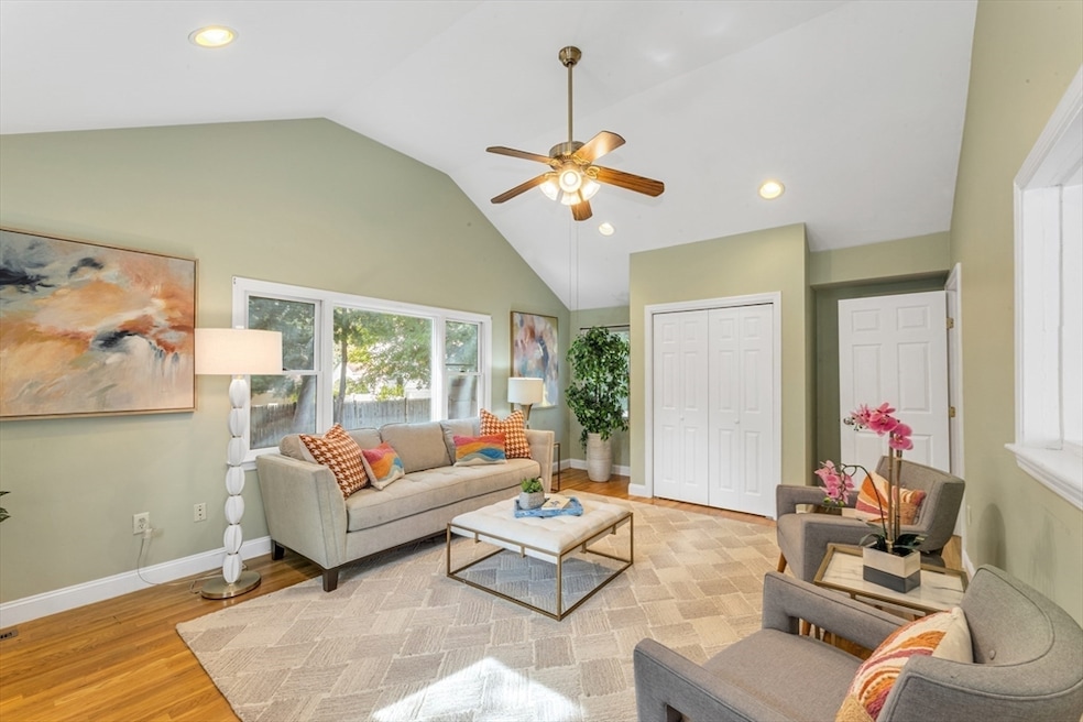
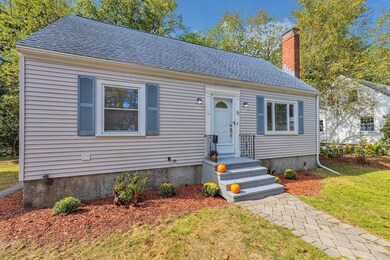
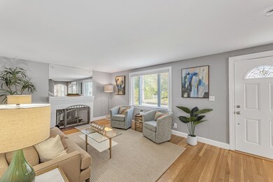
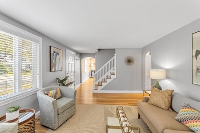
Charming Cape in Sought-After Brook Farm Neighborhood! Welcome to this delightful 3-bedroom, 2-bath Cape-style home offering a perfect blend of character and modern updates. The generous-sized living room features a cozy fireplace, ideal for relaxing or entertaining. A spacious dining room leads into the updated kitchen with stainless steel appliances, while a bright family room at the rear of the home boasts vaulted ceilings and overlooks the private backyard. The first-floor primary bedroom offers added convenience with a hallway full bath, while two additional bedrooms and a second full bath are located upstairs. Additional highlights include updated furnace & central air and roof. Partially finished basement offering flexible living or office space, and a well-maintained yard with a shed for storage. Enjoy a prime location close to major highways, VFW Parkway, Chestnut Hill, Longwood Medical, restaurants, and local parks & shopping district.
| Date | Buyer | Sale Price | Title Company |
|---|---|---|---|
| Costello Edmund | $837,500 | -- | |
| Zouzoulas Evan | $835,000 | -- | |
| Connor Elaine | $205,000 | -- | |
| Connor Elaine | $205,000 | -- | |
| Connor Elaine | $205,000 | -- | |
| Connor Elaine | $205,000 | -- |
| Date | Status | Borrower | Loan Amount |
|---|---|---|---|
| Previous Owner | Zouzoulas Evan | $600,000 | |
| Previous Owner | Connor Elaine | $188,000 | |
| Previous Owner | Connor Elaine | $160,000 |
| Date | Event | Price | List to Sale | Price per Sq Ft | Prior Sale |
|---|---|---|---|---|---|
| 10/21/2025 10/21/25 | Sold | $837,500 | +4.8% | $452 / Sq Ft | |
| 10/08/2025 10/08/25 | Pending | -- | -- | -- | |
| 10/01/2025 10/01/25 | For Sale | $799,000 | -4.3% | $432 / Sq Ft | |
| 07/30/2025 07/30/25 | Sold | $835,000 | +5.8% | $451 / Sq Ft | View Prior Sale |
| 06/25/2025 06/25/25 | Pending | -- | -- | -- | |
| 06/17/2025 06/17/25 | For Sale | $789,000 | -- | $426 / Sq Ft |
| Year | Tax Paid | Tax Assessment Tax Assessment Total Assessment is a certain percentage of the fair market value that is determined by local assessors to be the total taxable value of land and additions on the property. | Land | Improvement |
|---|---|---|---|---|
| 2025 | $8,437 | $728,600 | $249,800 | $478,800 |
| 2024 | $7,422 | $680,900 | $257,600 | $423,300 |
| 2023 | $7,099 | $661,000 | $250,100 | $410,900 |
| 2022 | $6,537 | $600,800 | $227,300 | $373,500 |
| 2021 | $6,048 | $566,800 | $216,500 | $350,300 |
| 2020 | $5,860 | $554,900 | $200,900 | $354,000 |
| 2019 | $5,624 | $533,600 | $164,500 | $369,100 |
| 2018 | $5,178 | $494,100 | $164,500 | $329,600 |
| 2017 | $5,128 | $484,200 | $164,500 | $319,700 |
| 2016 | $4,932 | $448,400 | $164,500 | $283,900 |
| 2015 | $5,468 | $451,500 | $184,800 | $266,700 |
| 2014 | $5,359 | $426,000 | $184,800 | $241,200 |
Seller's Agent in 2025
Lisa Sullivan
Insight Realty Group, Inc.
(617) 838-7361
22 in this area
58 Total Sales
Seller's Agent in 2025
Michael Helsmoortel
Coldwell Banker Realty - Brookline
(617) 686-5693
2 in this area
38 Total Sales
Seller Co-Listing Agent in 2025
Sue Brideau
Insight Realty Group, Inc.
(617) 285-5924
11 in this area
63 Total Sales
Buyer's Agent in 2025
Hickman - Coen Home Team
William Raveis R. E. & Home Services
(617) 416-8173
13 in this area
82 Total Sales
Source: MLS Property Information Network (MLS PIN)
MLS Number: 73438095
APN: WROX-000000-000020-007072
Disclaimer: Certain information contained herein is derived from information provided by parties other than Homes.com. All information provided is deemed reliable, but is not guaranteed to be accurate and should be independently verified.
![]() The property listing data and information, or the Images, set forth herein were provided to MLS Property Information Network, Inc. from third party sources, including sellers, lessors and public records, and were compiled by MLS Property Information Network, Inc. The property listing data and information, and the Images, are for the personal, non-commercial use of consumers having a good faith interest in purchasing or leasing listed properties of the type displayed to them and may not be used for any purpose other than to identify prospective properties which such consumers may have a good faith interest in purchasing or leasing. MLS Property Information Network, Inc. and its subscribers disclaim any and all representations and warranties as to the accuracy of the property listing data and information, or as to the accuracy of any of the Images, set forth herein.
The property listing data and information, or the Images, set forth herein were provided to MLS Property Information Network, Inc. from third party sources, including sellers, lessors and public records, and were compiled by MLS Property Information Network, Inc. The property listing data and information, and the Images, are for the personal, non-commercial use of consumers having a good faith interest in purchasing or leasing listed properties of the type displayed to them and may not be used for any purpose other than to identify prospective properties which such consumers may have a good faith interest in purchasing or leasing. MLS Property Information Network, Inc. and its subscribers disclaim any and all representations and warranties as to the accuracy of the property listing data and information, or as to the accuracy of any of the Images, set forth herein.
Ask me questions while you tour the home.