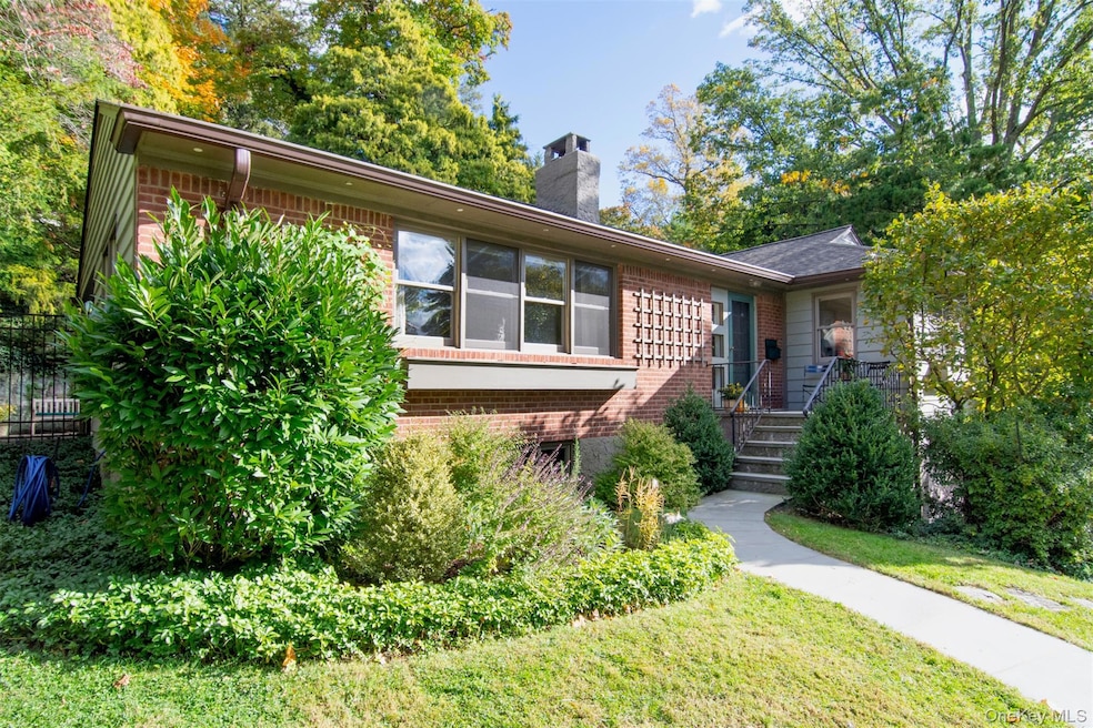
72 Magnolia Dr Dobbs Ferry, NY 10522
Estimated payment $8,392/month
Highlights
- Very Popular Property
- 2-Story Property
- Main Floor Bedroom
- Springhurst Elementary School Rated A
- Wood Flooring
- Mud Room
About This Home
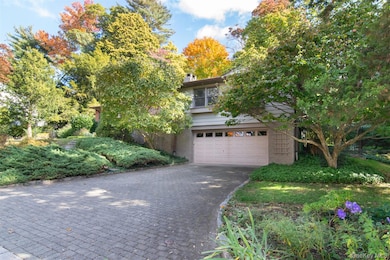
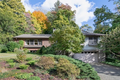
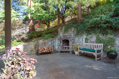
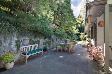
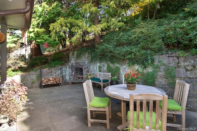
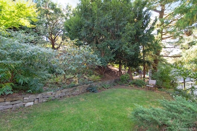
This meticulously updated and maintained home in the coveted neighborhood of Riverview Manor, is perfectly located to allow you to easily access both the vibrant and historic villages of Dobbs Ferry and Hastings-on-Hudson. This warm and inviting 1858 sq.ft. home offers over 600sq.ft. of additional space on the windowed lower level, ready for you to make it your own! Step inside to find a home that has been beautifully updated and meticulously maintained by the same family for over 25years. The entry hall welcomes you to a 24x14' living room where you will find both flow and space generous enough for large gatherings along with a cozy corner with wood burning fireplace perfect for curling up with a good book as you watch the sunset thru the western facing windows. Both the adjoining dining room and renovated eat-in-kitchen each feature french doors to the oversized outdoor patio where you will find the 2nd wood burning fireplace. The light filled eat-in-kitchen offers a wall of eastern facing windows overlooking the rear garden where a private outdoor oasis and habitat for birds awaits! The southern end of the home offers the primary bedroom with view and sliders to the rear garden and an en suite bath. Two additional bedrooms are flooded with western light and sunsets. The hall bath completes this level. The 4th bedroom and bath along with the 24x13’ tiled western facing room on the lower level is only the beginning of th great additional space you will find here. Family room, spacious home office or as part of an au pair or in law suite, you will be amazed at the possibilities to create a space of your own that compliments the spacious main living space. The bright tiled hall with closet that connects the garage to the lower level is a great space for a mudroom too! 2 additional walk in closets in the 16x11' laundry/utility room offers great storage. The .33 acre of thoughtfully curated property features shaded lawn areas, native plantings, peonies, azalea, iris, primrose and more from a garden that has been nurtured for 25yrs by the homeowners. Natures beauty will surround you as you enjoy a palette of continuous color complimented with stone paths, stairs and level lawn areas too. When not enjoying this special property, you can enjoy the quaint villages easily accessed by the Old Croton Aqueduct just a couple of blocks away or with a quick ride by car. Explore the historic riverfront villages where you will find award winning schools, dining, shopping, and waterfront parks offering on-going events and concerts along with spectacular sunsets over the Hudson River and Palisades. The Metro North Railroad offers a quick picturesque ride along the river to NYC! Welcome home where you will find the perfect balance of being close to all, yet far enough away to be fully immersed in the serenity of nature that abounds.
Listing Agent
Julia B Fee Sothebys Int. Rlty Brokerage Phone: 914-295-3500 License #40OT0906236 Listed on: 11/14/2025

Home Details
Home Type
- Single Family
Est. Annual Taxes
- $30,994
Year Built
- Built in 1953
Lot Details
- 0.33 Acre Lot
- Back Yard Fenced
Parking
- 1 Car Garage
Home Design
- 2-Story Property
- Wood Siding
Interior Spaces
- 1,858 Sq Ft Home
- Wood Burning Fireplace
- Mud Room
- Wood Flooring
Kitchen
- Range
- Microwave
- Dishwasher
Bedrooms and Bathrooms
- 4 Bedrooms
- Main Floor Bedroom
- 3 Full Bathrooms
Laundry
- Dryer
- Washer
Basement
- Basement Fills Entire Space Under The House
- Laundry in Basement
Outdoor Features
- Patio
Schools
- Springhurst Elementary School
- Dobbs Ferry Middle School
- Dobbs Ferry High School
Utilities
- Central Air
- Baseboard Heating
- Heating System Uses Natural Gas
- Natural Gas Connected
Listing and Financial Details
- Exclusions: Dining room, foyer, entry hall light fixtures. Primary curtain rod over slider. 2 freestanding laundry shelves
- Assessor Parcel Number 3.160-141-11
Map
Home Values in the Area
Average Home Value in this Area
Tax History
| Year | Tax Paid | Tax Assessment Tax Assessment Total Assessment is a certain percentage of the fair market value that is determined by local assessors to be the total taxable value of land and additions on the property. | Land | Improvement |
|---|---|---|---|---|
| 2024 | $29,173 | $1,026,500 | $759,800 | $266,700 |
| 2023 | $29,337 | $977,500 | $580,200 | $397,300 |
| 2022 | $26,764 | $935,000 | $580,200 | $354,800 |
| 2021 | $23,605 | $927,800 | $633,200 | $294,600 |
| 2020 | $23,172 | $745,900 | $562,100 | $183,800 |
| 2019 | $24,027 | $745,900 | $562,100 | $183,800 |
| 2018 | $26,746 | $725,000 | $562,100 | $162,900 |
| 2017 | $2,821 | $769,600 | $562,100 | $207,500 |
| 2016 | $691,945 | $846,900 | $643,200 | $203,700 |
| 2015 | -- | $17,300 | $3,650 | $13,650 |
| 2014 | -- | $17,300 | $3,650 | $13,650 |
| 2013 | $14,147 | $17,300 | $3,650 | $13,650 |
Property History
| Date | Event | Price | List to Sale | Price per Sq Ft |
|---|---|---|---|---|
| 11/14/2025 11/14/25 | For Sale | $1,100,000 | -- | $592 / Sq Ft |
Purchase History
| Date | Type | Sale Price | Title Company |
|---|---|---|---|
| Deed | $310,000 | Commonwealth Land Title Ins | |
| Deed | $430,000 | Lawyers Title Insurance Corp |
Source: OneKey® MLS
MLS Number: 933432
APN: 2603-003-160-00141-000-0011
Disclaimer: Certain information contained herein is derived from information provided by parties other than Homes.com. All information provided is deemed reliable, but is not guaranteed to be accurate and should be independently verified.
![]() The data relating to real estate for sale or lease on this web site comes in part from OneKey® MLS. Real estate listings held by brokerage firms other than Ten-X are marked with the OneKey® MLS logo or an abbreviated logo and detailed information about them includes the name of the listing broker.
The data relating to real estate for sale or lease on this web site comes in part from OneKey® MLS. Real estate listings held by brokerage firms other than Ten-X are marked with the OneKey® MLS logo or an abbreviated logo and detailed information about them includes the name of the listing broker.
IDX information is provided exclusively for personal, non-commercial use, and may not be used for any purpose other than to identify prospective properties consumers may be interested in purchasing.
Information is deemed reliable but not guaranteed.
Copyright 2025 OneKey® MLS. All rights reserved.
- 78 Oliphant Ave
- 7 Ravine Dr
- 177 Clinton Ave
- 132 Edgars Ln
- 11 Fairlawn Ave
- 737 N Broadway Unit 2D
- 18 Eldredge Place
- 33 Livingston Ave
- 40 Floral Dr
- 65 Circle Dr
- 565 Broadway Unit 1A
- 31 Maple Ave Unit 2A
- 555 Broadway Unit 1H
- 57 Maple Ave Unit 2B
- 31 Hillside Ave
- 63 Grandview Ave
- 24 School St
- 445 Broadway Unit 2R
- 445 Broadway Unit 2-O
- 445 Broadway Unit 3A
- 36 Broadway
- 35 Broadway
- 40 Main St
- 43 Main St
- 34 Clinton Ave Unit 5D
- 34 Clinton Ave Unit 9
- 34 Clinton Ave Unit 4
- 34 Clinton Ave Unit 2
- 34 Clinton Ave Unit 10
- 78 Main St
- 565 Broadway Unit 1F
- 381 Broadway Unit 1B
- 58 Main St Unit 1
- 29 Ridge Rd
- 2 Main St Unit 2E
- 24-82 Beacon Hill Dr
- 200 Beacon Hill Dr
- 100 Cedar St Unit A21
- 15 William St Unit 3W
- 451 Warburton Ave Unit 3