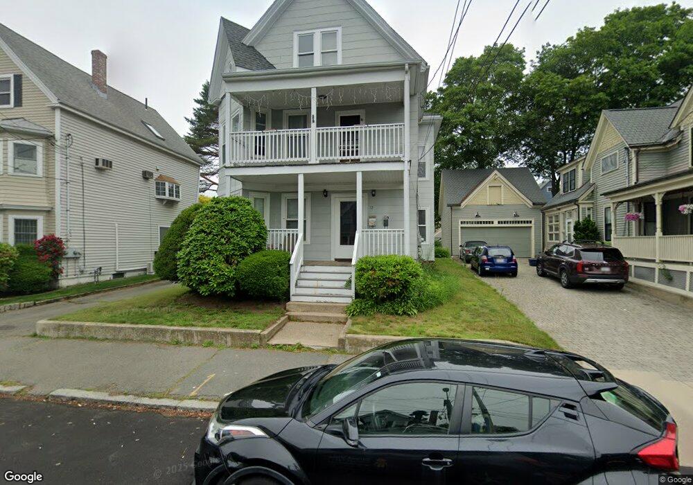
72 Middlesex Ave Swampscott, MA 01907
Estimated Value: $866,000 - $987,000
6
Beds
2
Baths
2,593
Sq Ft
$359/Sq Ft
Est. Value
About This Home
This home is located at 72 Middlesex Ave, Swampscott, MA 01907 and is currently estimated at $931,198, approximately $359 per square foot. 72 Middlesex Ave is a home located in Essex County with nearby schools including Swampscott Middle School and Swampscott High School.
Ownership History
Date
Name
Owned For
Owner Type
Purchase Details
Closed on
Jun 23, 2011
Sold by
Knight Pamela P
Bought by
Middlesex Ave 72 T
Current Estimated Value
Home Financials for this Owner
Home Financials are based on the most recent Mortgage that was taken out on this home.
Original Mortgage
$100,500
Interest Rate
4.81%
Purchase Details
Closed on
May 4, 2011
Sold by
Middlesex Avenue 72 T
Bought by
Knight Pamela P
Home Financials for this Owner
Home Financials are based on the most recent Mortgage that was taken out on this home.
Original Mortgage
$100,500
Interest Rate
4.81%
Purchase Details
Closed on
Nov 3, 1995
Sold by
72 Middlesex Ave Rt
Bought by
Knight Pamela P
Purchase Details
Closed on
Jan 5, 1987
Sold by
Flanagan John E
Bought by
Nelson George H
Create a Home Valuation Report for This Property
The Home Valuation Report is an in-depth analysis detailing your home's value as well as a comparison with similar homes in the area
Home Values in the Area
Average Home Value in this Area
Purchase History
| Date | Buyer | Sale Price | Title Company |
|---|---|---|---|
| Middlesex Ave 72 T | -- | -- | |
| Knight Pamela P | -- | -- | |
| Knight Pamela P | $135,000 | -- | |
| Nelson George H | $195,000 | -- |
Source: Public Records
Mortgage History
| Date | Status | Borrower | Loan Amount |
|---|---|---|---|
| Closed | Nelson George H | $100,500 | |
| Previous Owner | Nelson George H | $200,000 | |
| Previous Owner | Nelson George H | $126,000 |
Source: Public Records
Tax History
| Year | Tax Paid | Tax Assessment Tax Assessment Total Assessment is a certain percentage of the fair market value that is determined by local assessors to be the total taxable value of land and additions on the property. | Land | Improvement |
|---|---|---|---|---|
| 2025 | $8,828 | $769,700 | $291,500 | $478,200 |
| 2024 | $8,631 | $751,200 | $279,000 | $472,200 |
| 2023 | $8,403 | $715,800 | $266,500 | $449,300 |
| 2022 | $8,434 | $657,400 | $233,200 | $424,200 |
| 2021 | $8,368 | $606,400 | $216,600 | $389,800 |
| 2020 | $7,602 | $531,600 | $187,400 | $344,200 |
| 2019 | $7,036 | $462,900 | $141,600 | $321,300 |
| 2018 | $7,090 | $443,100 | $133,300 | $309,800 |
| 2017 | $6,865 | $393,400 | $124,900 | $268,500 |
| 2016 | $6,618 | $381,900 | $124,900 | $257,000 |
| 2015 | $6,407 | $373,600 | $116,600 | $257,000 |
| 2014 | $6,657 | $356,000 | $133,300 | $222,700 |
Source: Public Records
Map
Nearby Homes
- 106 Norfolk Ave
- 80 Norfolk Ave Unit 1
- 178 Norfolk Ave
- 46 Stetson Ave
- 64 Stetson Ave
- 146 Burrill St
- 4 Valley Rd Unit 4
- 11 Boynton St Unit 104
- 11 Boynton St Unit 101
- 11 Boynton St Unit 103
- 11 Boynton St Unit 204
- 28 Claremont Terrace Unit 6
- 49 Blaney St
- 32 Kings Beach Terrace
- 50 Mountwood Rd
- 168 Humphrey St Unit PH
- 60 Roy St
- 27 Rockland St
- 3 Didio Dr
- 97 Seymour Ave
- 72 Middlesex Ave Unit 1
- 68 Middlesex Ave
- 76 Middlesex Ave
- 121 Norfolk Ave
- 125 Norfolk Ave
- 64 Middlesex Ave
- 64 Middlesex Ave Unit 3
- 64 Middlesex Ave Unit 2
- 80 Middlesex Ave
- 117 Norfolk Ave
- 71 Middlesex Ave
- 113 Norfolk Ave
- 77 Middlesex Ave
- 133 Norfolk Ave
- 133 Norfolk Ave Unit 1
- 133 Norfolk Ave Unit 1
- 60 Middlesex Ave
- 84 Middlesex Ave
- 67 Middlesex Ave
- 109 Norfolk Ave
Your Personal Tour Guide
Ask me questions while you tour the home.