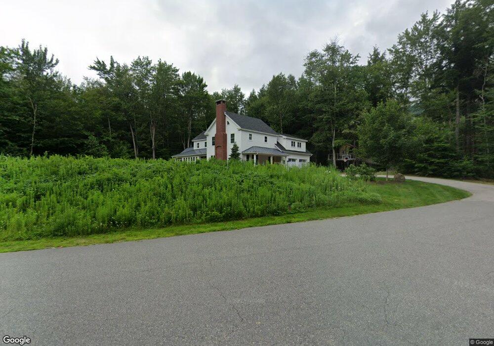
72 Pollard Rd Lincoln, NH 03251
Estimated Value: $903,000 - $1,245,000
4
Beds
4
Baths
3,412
Sq Ft
$314/Sq Ft
Est. Value
About This Home
This home is located at 72 Pollard Rd, Lincoln, NH 03251 and is currently estimated at $1,072,860, approximately $314 per square foot. 72 Pollard Rd is a home with nearby schools including Lin-Wood Public Elementary School, Lin-Wood Public Middle School, and Lin-Wood Public High School.
Ownership History
Date
Name
Owned For
Owner Type
Purchase Details
Closed on
Sep 30, 2024
Sold by
Martin James R and Martin Victoria J
Bought by
Martin Ft and Martin
Current Estimated Value
Purchase Details
Closed on
Sep 21, 2010
Sold by
Keeney Ann-Marie and Keeney Craig S
Bought by
Duquette Eugene J and Duquette Marie E
Create a Home Valuation Report for This Property
The Home Valuation Report is an in-depth analysis detailing your home's value as well as a comparison with similar homes in the area
Home Values in the Area
Average Home Value in this Area
Purchase History
| Date | Buyer | Sale Price | Title Company |
|---|---|---|---|
| Martin Ft | -- | None Available | |
| Martin Ft | -- | None Available | |
| Duquette Eugene J | $13,000 | -- | |
| Duquette Eugene J | $13,000 | -- |
Source: Public Records
Mortgage History
| Date | Status | Borrower | Loan Amount |
|---|---|---|---|
| Previous Owner | Duquette Eugene J | $417,000 | |
| Previous Owner | Duquette Eugene J | $40,000 | |
| Previous Owner | Duquette Eugene J | $150,000 |
Source: Public Records
Tax History
| Year | Tax Paid | Tax Assessment Tax Assessment Total Assessment is a certain percentage of the fair market value that is determined by local assessors to be the total taxable value of land and additions on the property. | Land | Improvement |
|---|---|---|---|---|
| 2024 | $8,044 | $688,700 | $164,800 | $523,900 |
| 2023 | $8,044 | $688,700 | $164,800 | $523,900 |
| 2022 | $7,266 | $688,700 | $164,800 | $523,900 |
| 2021 | $7,259 | $688,700 | $164,800 | $523,900 |
| 2018 | $762 | $522,300 | $98,600 | $423,700 |
| 2016 | $6,542 | $496,000 | $98,600 | $397,400 |
| 2015 | $5,713 | $414,600 | $113,400 | $301,200 |
| 2014 | $5,721 | $414,600 | $113,400 | $301,200 |
| 2009 | -- | $83,660 | $83,660 | $0 |
Source: Public Records
Map
Nearby Homes
- 51 Pollard Rd Unit 1
- 227 Main St Unit 106
- 16 Hillside Cir Unit 2
- 5 Hillside Cir Unit 1
- 5 White Oak Ln Unit 5
- 5 White Oak Ln Unit 8
- 36 Lodge Rd Unit A115
- 36 Lodge Rd Unit D213
- 36 Lodge Rd Unit L-302
- 36 Lodge Rd Unit C210
- 36 Lodge Rd Unit A313
- 36 Lodge Rd Unit 102
- 36 Lodge Rd Unit C-313
- 36 Lodge Rd Unit A-208
- 36 Lodge Rd Unit D115
- 52 Bunker Ln Unit 2
- 13 White Oak Ln Unit 3
- 13 Maple St
- 4A Ember Ct Unit 19A
- 37 Pinehill Ln Unit 2
Your Personal Tour Guide
Ask me questions while you tour the home.