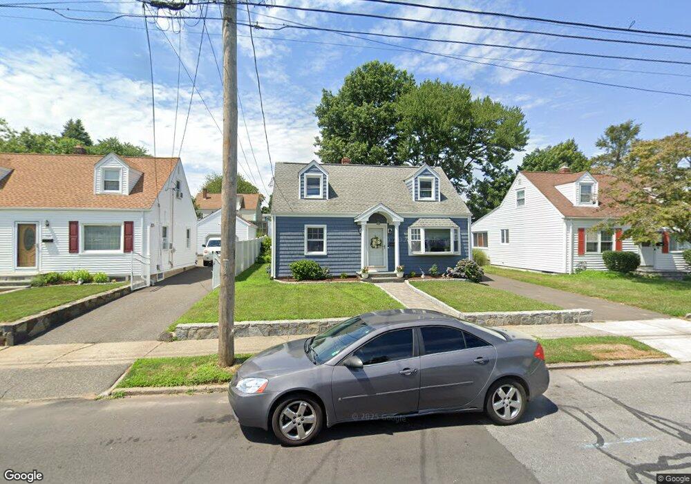
720 Birmingham St Bridgeport, CT 06606
North End NeighborhoodEstimated Value: $377,000 - $426,000
3
Beds
1
Bath
1,152
Sq Ft
$349/Sq Ft
Est. Value
About This Home
This home is located at 720 Birmingham St, Bridgeport, CT 06606 and is currently estimated at $401,872, approximately $348 per square foot. 720 Birmingham St is a home located in Fairfield County with nearby schools including Blackham School, Central High School, and Assumption Catholic School.
Ownership History
Date
Name
Owned For
Owner Type
Purchase Details
Closed on
Dec 1, 2006
Sold by
Koutsitzis Evangelos and Koutsitzis Elaine
Bought by
Sims Bonita
Current Estimated Value
Home Financials for this Owner
Home Financials are based on the most recent Mortgage that was taken out on this home.
Original Mortgage
$208,800
Outstanding Balance
$125,183
Interest Rate
6.36%
Estimated Equity
$276,689
Purchase Details
Closed on
Dec 12, 2002
Sold by
Deyo Richard and Deyo Amy M
Bought by
Koutsitzis Evangelos and -Koutsitzis Elaine
Purchase Details
Closed on
Mar 3, 1997
Sold by
Santini Josephine
Bought by
Deyo Amy M and Deyo Richard
Create a Home Valuation Report for This Property
The Home Valuation Report is an in-depth analysis detailing your home's value as well as a comparison with similar homes in the area
Home Values in the Area
Average Home Value in this Area
Purchase History
| Date | Buyer | Sale Price | Title Company |
|---|---|---|---|
| Sims Bonita | $261,000 | -- | |
| Sims Bonita | $261,000 | -- | |
| Koutsitzis Evangelos | $157,000 | -- | |
| Koutsitzis Evangelos | $157,000 | -- | |
| Deyo Amy M | $76,500 | -- | |
| Deyo Amy M | $76,500 | -- |
Source: Public Records
Mortgage History
| Date | Status | Borrower | Loan Amount |
|---|---|---|---|
| Open | Deyo Amy M | $208,800 | |
| Closed | Deyo Amy M | $52,200 | |
| Closed | Deyo Amy M | $208,800 |
Source: Public Records
Tax History Compared to Growth
Tax History
| Year | Tax Paid | Tax Assessment Tax Assessment Total Assessment is a certain percentage of the fair market value that is determined by local assessors to be the total taxable value of land and additions on the property. | Land | Improvement |
|---|---|---|---|---|
| 2025 | $6,734 | $154,980 | $75,310 | $79,670 |
| 2024 | $6,734 | $154,980 | $75,310 | $79,670 |
| 2023 | $6,734 | $154,980 | $75,310 | $79,670 |
| 2022 | $6,734 | $154,980 | $75,310 | $79,670 |
| 2021 | $6,734 | $154,980 | $75,310 | $79,670 |
| 2020 | $5,750 | $106,500 | $43,270 | $63,230 |
| 2019 | $5,750 | $106,500 | $43,270 | $63,230 |
| 2018 | $5,790 | $106,500 | $43,270 | $63,230 |
| 2017 | $5,790 | $106,500 | $43,270 | $63,230 |
| 2016 | $5,790 | $106,500 | $43,270 | $63,230 |
| 2015 | $5,678 | $134,550 | $49,980 | $84,570 |
| 2014 | $5,678 | $134,550 | $49,980 | $84,570 |
Source: Public Records
Map
Nearby Homes
- 669 Clark St
- 626 Merritt St
- 200 Stratfield Place
- 405 Ruth St
- 855 Burnsford Ave
- 954 Birmingham St
- 2346 Madison Ave
- 385 Burnsford Ave
- 1852 Madison Ave
- 2345 Madison Ave
- 3450 Park Ave
- 40 Northfield St
- 315 Clark St
- 3200 Park Ave Unit 7B2
- 3200 Park Ave Unit 6F1
- 3481 Park Ave
- 38 Enid St Unit B
- 681 Westfield Ave
- 339 Goldenrod Ave
- 325 Goldenrod Ave
- 710 Birmingham St
- 730 Birmingham St
- 700 Birmingham St
- 740 Birmingham St
- 625 Burnsford Ave
- 615 Burnsford Ave
- 635 Burnsford Ave
- 605 Burnsford Ave
- 750 Birmingham St
- 690 Birmingham St
- 719 Birmingham St
- 709 Birmingham St
- 731 Birmingham St
- 697 Birmingham St
- 595 Burnsford Ave
- 760 Birmingham St
- 745 Birmingham St
- 687 Birmingham St
- 665 Burnsford Ave
- 753 Birmingham St