720 Newport St Denver, CO 80220
Montclair NeighborhoodEstimated Value: $696,000 - $896,000
3
Beds
2
Baths
1,216
Sq Ft
$676/Sq Ft
Est. Value
About This Home
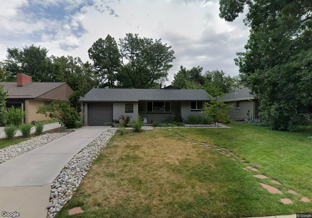
This home is located at 720 Newport St, Denver, CO 80220 and is currently estimated at $822,396, approximately $676 per square foot. 720 Newport St is a home located in Denver County with nearby schools including Montclair School of Academics and Enrichment, Hill Campus of Arts & Sciences, and George Washington High School.
Ownership History
Date
Name
Owned For
Owner Type
Purchase Details
Closed on
Feb 14, 2020
Sold by
Mackenzie James B and Mackenzie Carol O
Bought by
Monza Stephanie R and Monza Jules R
Current Estimated Value
Home Financials for this Owner
Home Financials are based on the most recent Mortgage that was taken out on this home.
Original Mortgage
$666,000
Outstanding Balance
$586,049
Interest Rate
3.72%
Mortgage Type
New Conventional
Estimated Equity
$236,347
Purchase Details
Closed on
Aug 13, 2001
Sold by
Mason Pamela A and Mason Daniel B
Bought by
Mackenzie James B and Mackenzie Carol O
Purchase Details
Closed on
May 20, 1994
Sold by
Pazirandeh Mohsen and Pazirandeh Donnamae
Bought by
Mason Pamela A and Mason Daniel B
Home Financials for this Owner
Home Financials are based on the most recent Mortgage that was taken out on this home.
Original Mortgage
$108,750
Interest Rate
8.4%
Mortgage Type
Purchase Money Mortgage
Create a Home Valuation Report for This Property
The Home Valuation Report is an in-depth analysis detailing your home's value as well as a comparison with similar homes in the area
Home Values in the Area
Average Home Value in this Area
Purchase History
| Date | Buyer | Sale Price | Title Company |
|---|---|---|---|
| Monza Stephanie R | $740,000 | Equity Title Of Colorado | |
| Mackenzie James B | $277,500 | -- | |
| Mason Pamela A | $145,000 | -- |
Source: Public Records
Mortgage History
| Date | Status | Borrower | Loan Amount |
|---|---|---|---|
| Open | Monza Stephanie R | $666,000 | |
| Previous Owner | Mason Pamela A | $108,750 |
Source: Public Records
Tax History
| Year | Tax Paid | Tax Assessment Tax Assessment Total Assessment is a certain percentage of the fair market value that is determined by local assessors to be the total taxable value of land and additions on the property. | Land | Improvement |
|---|---|---|---|---|
| 2025 | $4,532 | $64,330 | $34,780 | $34,780 |
| 2024 | $4,532 | $57,220 | $29,370 | $27,850 |
| 2023 | $4,434 | $57,220 | $29,370 | $27,850 |
| 2022 | $3,889 | $48,900 | $31,840 | $17,060 |
| 2021 | $3,753 | $50,300 | $32,750 | $17,550 |
| 2020 | $2,738 | $36,900 | $18,900 | $18,000 |
Source: Public Records
Map
Nearby Homes
- 7030 E 7th Ave
- 718 Locust St
- 822 Pontiac St
- 732 Poplar St
- 7134 E 6th Avenue Pkwy
- 812 Poplar St
- 477 Locust St
- 463 Locust St
- 431 Poplar St
- 300 Oneida St
- 750 Kearney St
- 7450 E 6th Ave
- 7444 E 9th Ave
- 1100 Pontiac St
- 7337 E 10th Ave
- 253 Oneida Ct
- 1045 Locust St
- 765 Kearney St
- 1035 Leyden St
- 1030 Krameria St
Your Personal Tour Guide
Ask me questions while you tour the home.