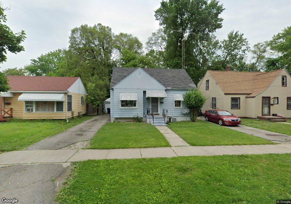
720 W Jamieson St Flint, MI 48504
Civic Park NeighborhoodEstimated Value: $34,000 - $63,000
3
Beds
2
Baths
1,117
Sq Ft
$41/Sq Ft
Est. Value
About This Home
This home is located at 720 W Jamieson St, Flint, MI 48504 and is currently estimated at $45,300, approximately $40 per square foot. 720 W Jamieson St is a home located in Genesee County with nearby schools including Brownell STEM Academy, The New Standard Academy, and Flint Cultural Center Academy.
Ownership History
Date
Name
Owned For
Owner Type
Purchase Details
Closed on
Jan 20, 2021
Sold by
Genesee County Land Bank Authority
Bought by
Perry Sybail Fay
Current Estimated Value
Purchase Details
Closed on
Jan 30, 2018
Sold by
The Genesee Ocunty Land Bank Authority
Bought by
Perry Sybail Fay
Purchase Details
Closed on
Feb 19, 2013
Sold by
Hardnett Darlynda
Bought by
Perry Lateaka
Purchase Details
Closed on
Dec 4, 2012
Sold by
Estate Of Wade Washington
Bought by
Hardnett Darlynda
Purchase Details
Closed on
Oct 31, 2005
Sold by
Washington Wade and Estate Of Bessie Mae Adams
Bought by
Washington Wade
Create a Home Valuation Report for This Property
The Home Valuation Report is an in-depth analysis detailing your home's value as well as a comparison with similar homes in the area
Home Values in the Area
Average Home Value in this Area
Purchase History
| Date | Buyer | Sale Price | Title Company |
|---|---|---|---|
| Perry Sybail Fay | $4,500 | None Available | |
| Perry Sybail Fay | -- | None Available | |
| Perry Lateaka | $5,000 | None Available | |
| Hardnett Darlynda | -- | None Available | |
| Washington Wade | -- | None Available |
Source: Public Records
Tax History Compared to Growth
Tax History
| Year | Tax Paid | Tax Assessment Tax Assessment Total Assessment is a certain percentage of the fair market value that is determined by local assessors to be the total taxable value of land and additions on the property. | Land | Improvement |
|---|---|---|---|---|
| 2025 | $690 | $14,700 | $0 | $0 |
| 2024 | $635 | $10,200 | $0 | $0 |
| 2023 | $630 | $8,700 | $0 | $0 |
| 2022 | $0 | $7,300 | $0 | $0 |
| 2021 | $648 | $7,000 | $0 | $0 |
| 2020 | $703 | $9,200 | $0 | $0 |
| 2019 | $733 | $10,000 | $0 | $0 |
| 2018 | $221 | $0 | $0 | $0 |
| 2017 | $1,404 | $0 | $0 | $0 |
| 2016 | $916 | $0 | $0 | $0 |
| 2015 | -- | $0 | $0 | $0 |
| 2014 | -- | $0 | $0 | $0 |
| 2012 | -- | $13,000 | $0 | $0 |
Source: Public Records
Map
Nearby Homes
- 3418 Keyes St
- 3002 N Chevrolet Ave
- 3513 Milbourne Ave
- 325 W Dewey St
- 409 W Genesee St
- 2718 N Chevrolet Ave
- 1209 W Mcclellan St
- 311 W Genesee St
- 3802 Milbourne Ave
- 1101 W Rankin St
- 200 W Mcclellan St
- 3722 Sterling St
- 4006 Donnelly St
- 1402 W Dartmouth St
- 3420 Fleming Rd
- 1521 W Dartmouth St
- 2913
- 2913 Martin Luther King Ave
- 1705 W Pasadena Ave
- 2907 Trumbull Ave
- 716 W Jamieson St
- 724 W Jamieson St
- 712 W Jamieson St
- 721 W Dewey St
- 715 W Dewey St
- 723 W Dewey St
- 3202 Keyes St
- 3206 Keyes St
- 711 W Dewey St
- 3205 Dupont St
- 3201 Dupont St
- 727 W Dewey St
- 719 W Jamieson St
- 3213 Dupont St
- 715 W Jamieson St
- 723 W Jamieson St
- 3217 Dupont St
- 3116 Keyes St
- 711 W Jamieson St
- 3112 Keyes St