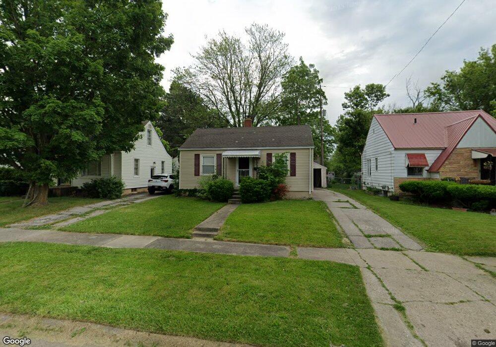
721 Mann Ave Flint, MI 48503
Glendale NeighborhoodEstimated Value: $44,000 - $60,000
2
Beds
1
Bath
638
Sq Ft
$80/Sq Ft
Est. Value
About This Home
This home is located at 721 Mann Ave, Flint, MI 48503 and is currently estimated at $51,307, approximately $80 per square foot. 721 Mann Ave is a home located in Genesee County with nearby schools including Durant-Tuuri-Mott Elementary School, St. Paul Lutheran School, and First Flint Seventh-day Adventist Christian School.
Ownership History
Date
Name
Owned For
Owner Type
Purchase Details
Closed on
Mar 15, 2016
Sold by
Vaughn Mitchell and Vaughn Jessica
Bought by
Munoz Briana
Current Estimated Value
Purchase Details
Closed on
Sep 24, 2013
Sold by
Gunter Charles H and Gunter Nicole L
Bought by
Vaughn Mitchell R and Vaughn Jessica M
Purchase Details
Closed on
May 13, 2013
Sold by
Gunter Charles H and Gunter Nicole L
Bought by
Vaughn Mitchell R and Vaughn Jessica H
Purchase Details
Closed on
Oct 25, 2000
Sold by
L Grimes J and L Marcia K
Bought by
Gunter Charlie H
Create a Home Valuation Report for This Property
The Home Valuation Report is an in-depth analysis detailing your home's value as well as a comparison with similar homes in the area
Home Values in the Area
Average Home Value in this Area
Purchase History
| Date | Buyer | Sale Price | Title Company |
|---|---|---|---|
| Munoz Briana | -- | Cislo Title Company | |
| Vaughn Mitchell R | -- | None Available | |
| Vaughn Mitchell R | -- | None Available | |
| Gunter Charlie H | $42,000 | Metropolitan Title Company |
Source: Public Records
Tax History
| Year | Tax Paid | Tax Assessment Tax Assessment Total Assessment is a certain percentage of the fair market value that is determined by local assessors to be the total taxable value of land and additions on the property. | Land | Improvement |
|---|---|---|---|---|
| 2025 | $868 | $20,500 | $0 | $0 |
| 2024 | $791 | $17,700 | $0 | $0 |
| 2023 | $779 | $12,900 | $0 | $0 |
| 2022 | $0 | $11,000 | $0 | $0 |
| 2021 | $807 | $10,100 | $0 | $0 |
| 2020 | $732 | $9,900 | $0 | $0 |
| 2019 | $716 | $9,700 | $0 | $0 |
| 2018 | $942 | $9,400 | $0 | $0 |
| 2017 | $1,349 | $0 | $0 | $0 |
| 2016 | $944 | $0 | $0 | $0 |
| 2015 | -- | $0 | $0 | $0 |
| 2014 | -- | $0 | $0 | $0 |
| 2012 | -- | $12,600 | $0 | $0 |
Source: Public Records
Map
Nearby Homes
- 3302 Van Buren Ave
- 916 Mann Ave
- 3517 Norwood Dr
- 911 Hughes Ave
- 960 Mann Ave
- 3405 Sherwood Dr
- 0000 Beecher Rd
- 976 Barney Ave
- 2710 Mansfield Ave
- 3617 Sherwood Dr
- 3709 Brentwood Dr
- 3320 Pencombe Place
- 945 Salisbury Ave
- 932 Bradley Ave
- 2663 W Court St
- 320 Sheffield Ave
- 1017 Stocker Ave
- 314 Sheffield Ave
- 863 Tacken St
- 870 Tacken St
Your Personal Tour Guide
Ask me questions while you tour the home.