A
Seller's Agent in 2014
Ann Thomas
Frison Realty & Construction Co
(229) 347-2457
43 Total Sales
Estimated Value: $149,000 - $203,000
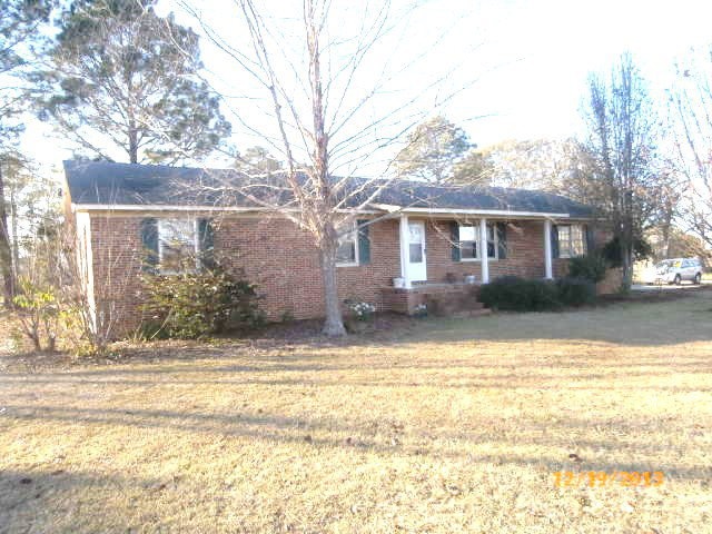
Good location. In city limits.Great for first time home buyer.Screen porch with built-in BBQ grill,sink and wired for TV.Nice rear yard for family gatherings.
Last Agent to Sell the Property
Frison Realty & Construction Co Brokerage Phone: 2294366628 License #43940 Listed on: 06/18/2014
Last Buyer's Agent
Frison Realty & Construction Co Brokerage Phone: 2294366628 License #43940 Listed on: 06/18/2014
| Date | Buyer | Sale Price | Title Company |
|---|---|---|---|
| Hiers Jimmy W | $3,500 | -- | |
| Sampson Brandon L | $38,000 | -- | |
| Deutsche Bank National Trust C | $76,000 | -- | |
| Simmons Shanna | -- | -- | |
| Simmons Darrell | $55,000 | -- | |
| Davidson E H | $44,000 | -- |
| Date | Event | Price | List to Sale | Price per Sq Ft |
|---|---|---|---|---|
| 07/24/2014 07/24/14 | Sold | $38,000 | -- | $24 / Sq Ft |
| 06/18/2014 06/18/14 | Pending | -- | -- | -- |
| Year | Tax Paid | Tax Assessment Tax Assessment Total Assessment is a certain percentage of the fair market value that is determined by local assessors to be the total taxable value of land and additions on the property. | Land | Improvement |
|---|---|---|---|---|
| 2024 | $2,003 | $64,445 | $2,761 | $61,684 |
| 2023 | $1,666 | $44,514 | $2,761 | $41,753 |
| 2022 | $1,214 | $40,979 | $2,761 | $38,218 |
| 2021 | $1,083 | $35,763 | $2,761 | $33,002 |
| 2020 | $1,103 | $35,763 | $2,761 | $33,002 |
| 2019 | $1,218 | $35,763 | $2,761 | $33,002 |
| 2018 | $1,177 | $34,833 | $1,461 | $33,372 |
| 2017 | $1,170 | $34,833 | $1,461 | $33,372 |
| 2016 | $1,177 | $34,833 | $1,461 | $33,372 |
| 2015 | $514 | $34,833 | $1,461 | $33,372 |
| 2014 | $1,057 | $33,333 | $1,461 | $31,872 |
| 2013 | -- | $33,332 | $1,460 | $31,872 |
A
Seller's Agent in 2014
Ann Thomas
Frison Realty & Construction Co
(229) 347-2457
43 Total Sales
Source: Albany Board of REALTORS®
MLS Number: 130391
APN: D001-069
