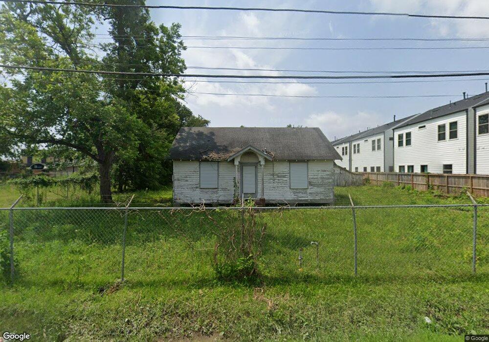
721 Thornton Rd Houston, TX 77018
Oak Forest-Garden Oaks NeighborhoodEstimated Value: $274,000 - $554,000
2
Beds
1
Bath
952
Sq Ft
$480/Sq Ft
Est. Value
About This Home
This home is located at 721 Thornton Rd, Houston, TX 77018 and is currently estimated at $456,682, approximately $479 per square foot. 721 Thornton Rd is a home located in Harris County with nearby schools including Durham Elementary School, Frank Black Middle School, and Waltrip High School.
Ownership History
Date
Name
Owned For
Owner Type
Purchase Details
Closed on
Apr 17, 2025
Sold by
Ball Leonard V L
Bought by
721 Thornton Rd Development Llc
Current Estimated Value
Purchase Details
Closed on
Mar 14, 2025
Sold by
Ball Leonard V L
Bought by
0 Curtin St Development Llc
Create a Home Valuation Report for This Property
The Home Valuation Report is an in-depth analysis detailing your home's value as well as a comparison with similar homes in the area
Home Values in the Area
Average Home Value in this Area
Purchase History
| Date | Buyer | Sale Price | Title Company |
|---|---|---|---|
| 721 Thornton Rd Development Llc | -- | None Listed On Document | |
| 0 Curtin St Development Llc | -- | None Listed On Document |
Source: Public Records
Tax History Compared to Growth
Tax History
| Year | Tax Paid | Tax Assessment Tax Assessment Total Assessment is a certain percentage of the fair market value that is determined by local assessors to be the total taxable value of land and additions on the property. | Land | Improvement |
|---|---|---|---|---|
| 2025 | $11,226 | $612,335 | $579,600 | $32,735 |
| 2024 | $11,226 | $536,503 | $510,600 | $25,903 |
| 2023 | $11,226 | $472,500 | $441,600 | $30,900 |
| 2022 | $9,116 | $414,000 | $413,900 | $100 |
| 2021 | $8,484 | $363,997 | $363,897 | $100 |
| 2020 | $7,689 | $317,500 | $317,400 | $100 |
| 2019 | $3,543 | $140,000 | $139,900 | $100 |
| 2018 | $1,521 | $173,892 | $165,600 | $8,292 |
| 2017 | $2,096 | $93,264 | $82,800 | $10,464 |
| 2016 | $2,358 | $93,264 | $82,800 | $10,464 |
| 2015 | -- | $92,975 | $82,800 | $10,175 |
| 2014 | -- | $90,702 | $82,800 | $7,902 |
Source: Public Records
Map
Nearby Homes
- 9388 Plan at Thornton Oaks
- 9384 Plan at Thornton Oaks
- 811 Thornton Rd Unit B
- 719 Thornton Rd Unit B
- 719 Thornton Rd Unit E
- 719 Thornton Rd Unit A
- 719 Thornton Rd Unit F
- 752 Curtin St
- 750 Curtin St
- 748 Curtin St
- 744 Curtin St
- 742 Curtin St
- 812 Thornton Rd Unit B
- 817 Thornton Rd Unit G
- 817 Thornton Rd Unit F
- 808 Woodcrest Dr Unit A
- 535 Azaleadell Dr
- 807 Martin St Unit D
- 807 Martin St Unit C
- 4703 Thornton Grove
- 719 Thornton Rd
- 803 Thornton Rd
- 803 Thornton Rd Unit D
- 803 Thornton Rd Unit J
- 803 Thornton Rd Unit I
- 803 Thornton Rd Unit C
- 803 Thornton Rd Unit B
- 803 Thornton Rd Unit H
- 803 Thornton Rd Unit G
- 803 Thornton Rd Unit E
- 803 Thornton Rd Unit A
- 803 Thornton Rd Unit F
- 715 Thornton Rd
- 809 Thornton Rd
- 4617 Shepherd Dr
- 714 Curtin St
- 800 Curtin St
- 710 Curtin St
- 704 Thornton Rd
- 706 Curtin St