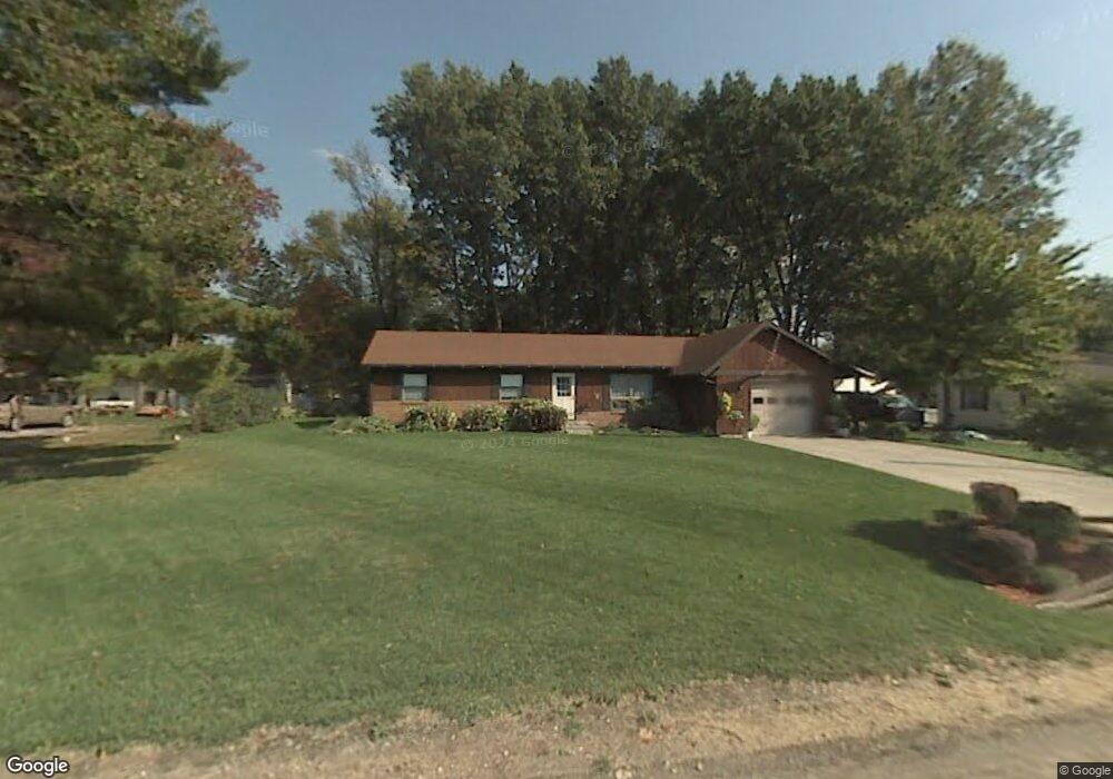
7210 Dunbar Rd Temperance, MI 48182
Estimated Value: $240,564 - $258,000
3
Beds
2
Baths
1,472
Sq Ft
$169/Sq Ft
Est. Value
About This Home
This home is located at 7210 Dunbar Rd, Temperance, MI 48182 and is currently estimated at $248,891, approximately $169 per square foot. 7210 Dunbar Rd is a home located in Monroe County with nearby schools including Douglas Road Elementary School, Bedford Junior High School, and Bedford High School.
Ownership History
Date
Name
Owned For
Owner Type
Purchase Details
Closed on
May 23, 2025
Sold by
Briskey Jennifer Ann
Bought by
Karl Margaret
Current Estimated Value
Home Financials for this Owner
Home Financials are based on the most recent Mortgage that was taken out on this home.
Original Mortgage
$245,471
Outstanding Balance
$244,632
Interest Rate
6.83%
Mortgage Type
FHA
Estimated Equity
$4,259
Purchase Details
Closed on
Jul 20, 2018
Sold by
Ann Briskey Jennifer
Bought by
Briskey Jennifer Ann
Purchase Details
Closed on
Jul 10, 2018
Sold by
Ann Briskey Jennifer
Bought by
Briskey Jennifer Ann and Davis Theresa M
Create a Home Valuation Report for This Property
The Home Valuation Report is an in-depth analysis detailing your home's value as well as a comparison with similar homes in the area
Home Values in the Area
Average Home Value in this Area
Purchase History
| Date | Buyer | Sale Price | Title Company |
|---|---|---|---|
| Karl Margaret | $250,000 | Lawyers Title Agency Of Monroe | |
| Briskey Jennifer Ann | -- | None Listed On Document | |
| Briskey Jennifer Ann | -- | None Listed On Document |
Source: Public Records
Mortgage History
| Date | Status | Borrower | Loan Amount |
|---|---|---|---|
| Open | Karl Margaret | $245,471 |
Source: Public Records
Tax History Compared to Growth
Tax History
| Year | Tax Paid | Tax Assessment Tax Assessment Total Assessment is a certain percentage of the fair market value that is determined by local assessors to be the total taxable value of land and additions on the property. | Land | Improvement |
|---|---|---|---|---|
| 2025 | $1,595 | $100,500 | $100,500 | $0 |
| 2024 | $652 | $94,700 | $0 | $0 |
| 2023 | $621 | $81,100 | $0 | $0 |
| 2022 | $1,469 | $81,100 | $0 | $0 |
| 2021 | $1,404 | $83,300 | $0 | $0 |
| 2020 | $1,347 | $64,800 | $0 | $0 |
| 2019 | $1,332 | $64,800 | $0 | $0 |
| 2018 | $1,203 | $60,800 | $0 | $0 |
| 2017 | $1,144 | $60,800 | $0 | $0 |
| 2016 | $1,143 | $60,700 | $0 | $0 |
| 2015 | $1,071 | $54,200 | $0 | $0 |
| 2014 | $1,071 | $54,200 | $0 | $0 |
| 2013 | $1,231 | $47,100 | $0 | $0 |
Source: Public Records
Map
Nearby Homes
- 2219 Camden Ln
- 6913 Lexington Place
- 6911 Summerfield Rd
- 2270 Reddington Dr
- 7104 Stockport Dr
- 2863 Wiltshire Dr
- 6886 Stockport Dr
- 2816 Floyd Rd
- 6644 Douglas Rd
- 2665 Miller St
- 2049 W Sterns Rd
- 7479 Wilfred Dr
- 2807 W Smith
- 3009 Sterns Rd
- 3155 Chanson Valley Rd
- 1670 Spruce Ct Unit 1
- 3231 Ravine Hollow Ct
- 3216 Ravine Hollow Ct
- 3215 Edgevale Dr
- 1660 W Sterns Rd
- 7206 Dunbar Rd
- 7206 Dunbar Rd
- 7214 Dunbar Rd
- 7009 Taylor Ave
- 7211 Dunbar Rd
- 7015 Taylor Ave
- 7005 Taylor Ave
- 7218 Dunbar Rd
- 7215 Dunbar Rd
- 7213 Dunbar Rd
- 7019 Taylor Ave
- 7001 Taylor Ave
- 2450 Oakdale Ave
- 7006 Taylor Ave
- 7072 Powlesland Ave
- 7222 Dunbar Rd
- 7027 Taylor Ave
- 7090 Powlesland Ave
- 7020 Taylor Ave
- 7016 Taylor Ave