
Seller's Agent in 2025
Christopher Fresquez
Simply Vegas
(702) 419-4346
1 in this area
15 Total Sales
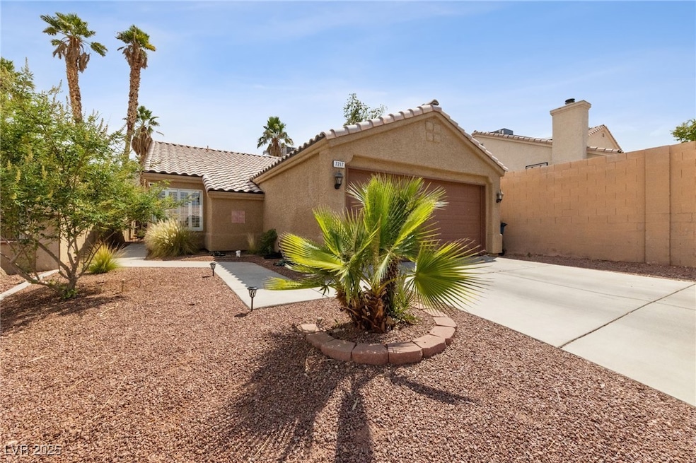


Well taken care of charming 2 bedroom , 2 bath single story home situated at the end of a cul-de-sac. The home features new interior paint, brand new ceiling fans, window coverings and well taken care of tile flooring throughout. This home also has a very low maintenance desert landscaped front and backyard. The backyard also features a covered patio which remains shaded throughout the day as the home faces north. Freshly painted garage also comes equipped with storage cabinets. Plus No HOA.
Last Agent to Sell the Property
Simply Vegas Brokerage Phone: (702) 419-4346 License #S.0197081 Listed on: 07/21/2025
| Date | Type | Sale Price | Title Company |
|---|---|---|---|
| Bargain Sale Deed | $365,000 | Wfg National Title Insurance C | |
| Interfamily Deed Transfer | -- | None Available | |
| Bargain Sale Deed | $215,000 | -- | |
| Bargain Sale Deed | $115,000 | Old Republic Title Company |
| Date | Status | Loan Amount | Loan Type |
|---|---|---|---|
| Previous Owner | $115,000 | Unknown | |
| Previous Owner | $114,213 | FHA |
| Date | Event | Price | List to Sale | Price per Sq Ft |
|---|---|---|---|---|
| 08/28/2025 08/28/25 | Sold | $365,000 | +2.8% | $323 / Sq Ft |
| 07/31/2025 07/31/25 | Pending | -- | -- | -- |
| 07/21/2025 07/21/25 | For Sale | $355,000 | -- | $314 / Sq Ft |
| Year | Tax Paid | Tax Assessment Tax Assessment Total Assessment is a certain percentage of the fair market value that is determined by local assessors to be the total taxable value of land and additions on the property. | Land | Improvement |
|---|---|---|---|---|
| 2025 | $1,307 | $70,086 | $32,200 | $37,886 |
| 2024 | $1,270 | $70,086 | $32,200 | $37,886 |
| 2023 | $1,270 | $65,737 | $29,400 | $36,337 |
| 2022 | $1,233 | $58,246 | $24,850 | $33,396 |
| 2021 | $1,197 | $53,341 | $21,350 | $31,991 |
| 2020 | $1,159 | $52,569 | $20,650 | $31,919 |
| 2019 | $1,145 | $50,469 | $18,900 | $31,569 |
| 2018 | $1,093 | $44,940 | $14,350 | $30,590 |
| 2017 | $1,434 | $43,738 | $12,600 | $31,138 |
| 2016 | $1,024 | $41,553 | $10,150 | $31,403 |
| 2015 | $1,021 | $37,665 | $8,400 | $29,265 |
| 2014 | $991 | $29,328 | $6,300 | $23,028 |
Seller's Agent in 2025
Christopher Fresquez
Simply Vegas
(702) 419-4346
1 in this area
15 Total Sales
M
Buyer's Agent in 2025
Margie Cronkite
Realty ONE Group, Inc
(702) 378-5869
4 in this area
40 Total Sales
Source: Las Vegas REALTORS®
MLS Number: 2703183
APN: 138-22-811-083
Disclaimer: Certain information contained herein is derived from information provided by parties other than Homes.com. All information provided is deemed reliable, but is not guaranteed to be accurate and should be independently verified.
![]() The data relating to real estate for sale on this web site comes in part from the INTERNET DATA EXCHANGE Program of the Greater Las Vegas Association of REALTORS® MLS. Real estate listings held by brokerage firms other than this site owner are marked with the IDX logo. Information is deemed reliable but not guaranteed. Copyright 2025 of the Greater Las Vegas Association of REALTORS® MLS. All rights reserved.
The data relating to real estate for sale on this web site comes in part from the INTERNET DATA EXCHANGE Program of the Greater Las Vegas Association of REALTORS® MLS. Real estate listings held by brokerage firms other than this site owner are marked with the IDX logo. Information is deemed reliable but not guaranteed. Copyright 2025 of the Greater Las Vegas Association of REALTORS® MLS. All rights reserved.