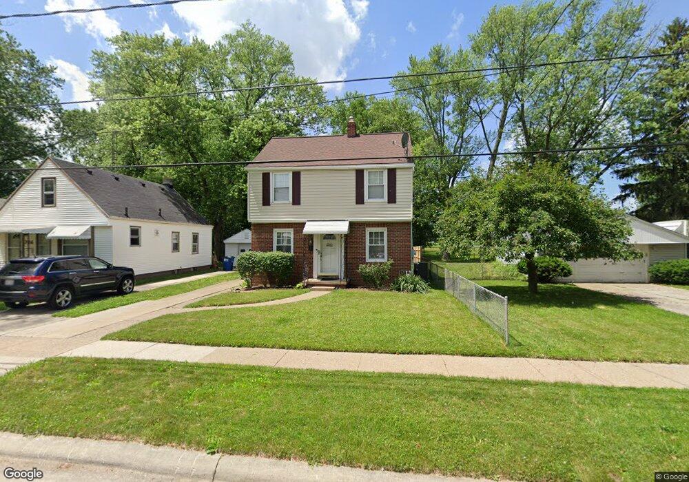
722 Barclay Dr Toledo, OH 43609
Southside NeighborhoodEstimated Value: $99,000 - $155,000
4
Beds
1
Bath
1,530
Sq Ft
$77/Sq Ft
Est. Value
About This Home
This home is located at 722 Barclay Dr, Toledo, OH 43609 and is currently estimated at $117,542, approximately $76 per square foot. 722 Barclay Dr is a home located in Lucas County with nearby schools including Burroughs Elementary School, Bowsher High School, and Explorers Academy of Science and Technology.
Ownership History
Date
Name
Owned For
Owner Type
Purchase Details
Closed on
Apr 25, 2017
Sold by
White Jeffrey L
Bought by
Byrne Julie Ann and White Trusts
Current Estimated Value
Purchase Details
Closed on
Jun 1, 1998
Sold by
Calipetro Patricia A and Nyler Patricia A
Bought by
White Jeffrey L
Home Financials for this Owner
Home Financials are based on the most recent Mortgage that was taken out on this home.
Original Mortgage
$76,000
Outstanding Balance
$14,211
Interest Rate
7.27%
Estimated Equity
$103,331
Create a Home Valuation Report for This Property
The Home Valuation Report is an in-depth analysis detailing your home's value as well as a comparison with similar homes in the area
Home Values in the Area
Average Home Value in this Area
Purchase History
| Date | Buyer | Sale Price | Title Company |
|---|---|---|---|
| Byrne Julie Ann | -- | None Available | |
| White Jeffrey L | $80,000 | Northwest Title Agency Of Oh |
Source: Public Records
Mortgage History
| Date | Status | Borrower | Loan Amount |
|---|---|---|---|
| Open | White Jeffrey L | $76,000 |
Source: Public Records
Tax History
| Year | Tax Paid | Tax Assessment Tax Assessment Total Assessment is a certain percentage of the fair market value that is determined by local assessors to be the total taxable value of land and additions on the property. | Land | Improvement |
|---|---|---|---|---|
| 2025 | -- | $31,395 | $4,480 | $26,915 |
| 2024 | $957 | $31,395 | $4,480 | $26,915 |
| 2023 | $1,469 | $22,750 | $3,150 | $19,600 |
| 2022 | $1,474 | $22,750 | $3,150 | $19,600 |
| 2021 | $1,510 | $22,750 | $3,150 | $19,600 |
| 2020 | $1,690 | $22,715 | $3,115 | $19,600 |
| 2019 | $1,643 | $22,715 | $3,115 | $19,600 |
| 2018 | $1,662 | $22,715 | $3,115 | $19,600 |
| 2017 | $1,692 | $22,190 | $3,045 | $19,145 |
| 2016 | $1,689 | $63,400 | $8,700 | $54,700 |
| 2015 | $1,674 | $63,400 | $8,700 | $54,700 |
| 2014 | $1,396 | $22,200 | $3,050 | $19,150 |
| 2013 | $1,396 | $22,200 | $3,050 | $19,150 |
Source: Public Records
Map
Nearby Homes
- 732 Colima Dr
- 518 Colima Dr
- 546 Elmdale Rd
- 536 Foredale Ave
- 560 Williamsville Ave
- 2335 Airport Hwy
- 1313 Stanwix Dr
- 139 Kenmore Ave
- 333 Danberry St
- 415 Mayberry St
- 2052 South Ave
- 1422 Leith Dr
- 2019 South Ave
- 256 Decatur St
- 511 S Detroit Ave
- 1922 Heatherdale Dr
- 2010 Airport Hwy
- 859 National Ave
- 2144 Aberdeen Ave
- 1339 Almon Ave
- 726 Barclay Dr
- 714 Barclay Dr
- 730 Barclay Dr
- 710 Barclay Dr
- 734 Barclay Dr
- 706 Barclay Dr
- 740 Barclay Dr
- 719 Barclay Dr
- 723 Barclay Dr
- 715 Barclay Dr
- 727 Barclay Dr
- 711 Barclay Dr
- 702 Barclay Dr
- 731 Barclay Dr
- 707 Barclay Dr
- 746 Barclay Dr
- 654 Barclay Dr
- 703 Barclay Dr
- 2734 Stateview Dr
- 741 Barclay Dr
Your Personal Tour Guide
Ask me questions while you tour the home.