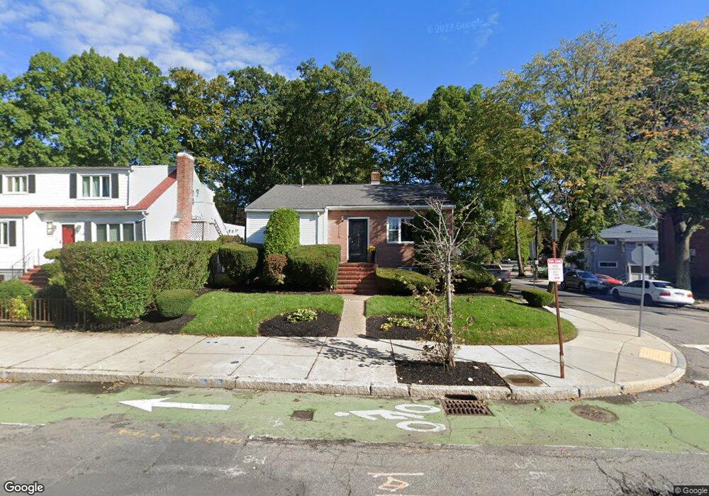
722 Cummins Hwy Mattapan, MA 02126
Southern Mattapan NeighborhoodEstimated Value: $501,000 - $597,000
3
Beds
2
Baths
1,047
Sq Ft
$521/Sq Ft
Est. Value
About This Home
This home is located at 722 Cummins Hwy, Mattapan, MA 02126 and is currently estimated at $545,532, approximately $521 per square foot. 722 Cummins Hwy is a home located in Suffolk County with nearby schools including Codman Academy Charter Public School, KIPP Academy Boston Charter School, and Brooke Charter School Roslindale.
Create a Home Valuation Report for This Property
The Home Valuation Report is an in-depth analysis detailing your home's value as well as a comparison with similar homes in the area
Home Values in the Area
Average Home Value in this Area
Tax History Compared to Growth
Tax History
| Year | Tax Paid | Tax Assessment Tax Assessment Total Assessment is a certain percentage of the fair market value that is determined by local assessors to be the total taxable value of land and additions on the property. | Land | Improvement |
|---|---|---|---|---|
| 2025 | $4,629 | $399,700 | $161,200 | $238,500 |
| 2024 | $4,546 | $417,100 | $159,200 | $257,900 |
| 2023 | $4,265 | $397,100 | $151,600 | $245,500 |
| 2022 | $4,002 | $367,800 | $140,400 | $227,400 |
| 2021 | $3,679 | $344,800 | $133,700 | $211,100 |
| 2020 | $2,808 | $265,900 | $134,200 | $131,700 |
| 2019 | $2,695 | $255,700 | $100,600 | $155,100 |
| 2018 | $2,505 | $239,000 | $100,600 | $138,400 |
| 2017 | $2,435 | $229,900 | $100,600 | $129,300 |
| 2016 | $2,299 | $209,000 | $100,600 | $108,400 |
| 2015 | $2,301 | $190,000 | $94,000 | $96,000 |
| 2014 | $2,193 | $174,300 | $94,000 | $80,300 |
Source: Public Records
Map
Nearby Homes
- 839-843 Cummins Hwy
- 231 Itasca St
- 770 Cummins Hwy Unit 1
- 770 Cummins Hwy Unit 22
- 10 Brockton St
- 34 Ridlon Rd
- 95 Woodhaven St
- 90 Hollingsworth St
- 179 Hebron St
- 265 Hebron St
- 23 Caton St
- 72 Livermore St
- 48-50 Rockdale St
- 100 Itasca St
- 25 Alpine St Unit 7
- 20 Monterey Ave
- 7 Winborough St
- 645 River St
- 60 and 64 Monterey Ave
- 0 Tina Ave
- 718 Cummins Hwy
- 2 Corman Rd
- 714 Cummins Hwy
- 714 Cummins Hwy
- 714 Cummins Hwy Unit 2
- 714 Cummins Hwy Unit 1
- 13 Corman Rd
- 3 Corman Rd
- 1 Corman Rd Unit 1
- 3 Corman Rd Unit 2
- 1-3 Corman Rd
- 728 Cummins Hwy Unit 8
- 728 Cummins Hwy Unit 7
- 250 Savannah Ave
- 4 Corman Rd
- 254 Savannah Ave
- 730 Cummins Hwy
- 730 Cummins Hwy Unit 6
- 730 Cummins Hwy Unit 5
- 730 Cummins Hwy Unit 4