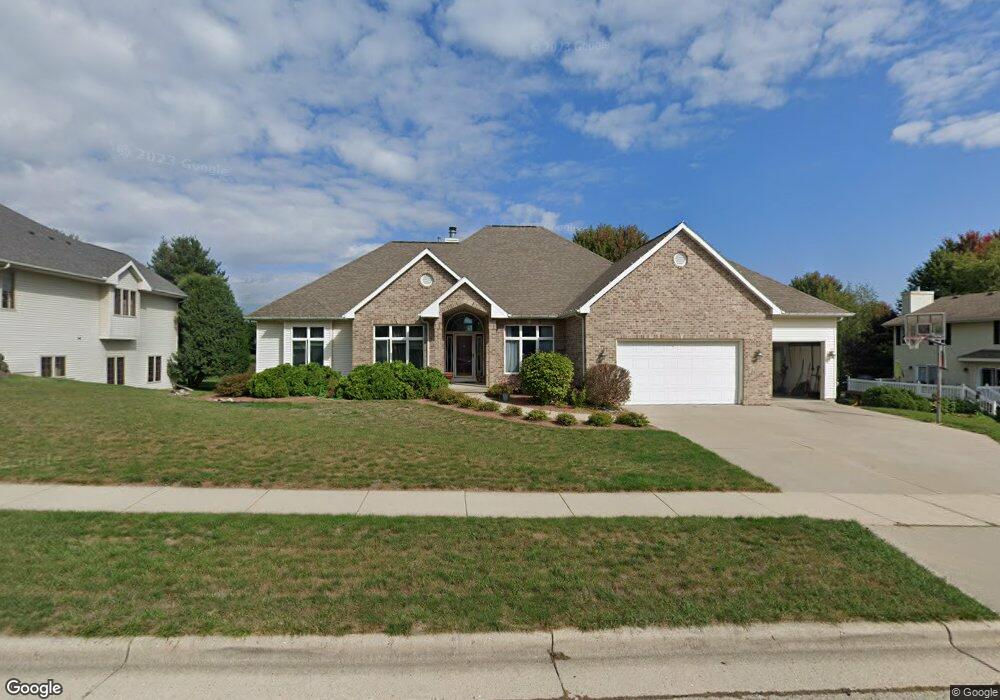
722 Foxfield Rd Oregon, WI 53575
Estimated Value: $696,000 - $885,000
4
Beds
4
Baths
3,188
Sq Ft
$246/Sq Ft
Est. Value
About This Home
This home is located at 722 Foxfield Rd, Oregon, WI 53575 and is currently estimated at $784,397, approximately $246 per square foot. 722 Foxfield Rd is a home located in Dane County with nearby schools including Oregon Middle School, Rome Corners Intermediate School, and Oregon High School.
Ownership History
Date
Name
Owned For
Owner Type
Purchase Details
Closed on
Feb 16, 2018
Sold by
Moyer Jon R
Bought by
Moyer Jennifer A
Current Estimated Value
Purchase Details
Closed on
May 30, 2007
Sold by
Moran Michael P and Moran Lorrie A
Bought by
Moyer Jon R and Moyer Jennifer A
Home Financials for this Owner
Home Financials are based on the most recent Mortgage that was taken out on this home.
Original Mortgage
$280,000
Outstanding Balance
$169,853
Interest Rate
6.21%
Mortgage Type
Purchase Money Mortgage
Estimated Equity
$614,544
Create a Home Valuation Report for This Property
The Home Valuation Report is an in-depth analysis detailing your home's value as well as a comparison with similar homes in the area
Home Values in the Area
Average Home Value in this Area
Purchase History
| Date | Buyer | Sale Price | Title Company |
|---|---|---|---|
| Moyer Jennifer A | -- | -- | |
| Moyer Jon R | $450,000 | None Available |
Source: Public Records
Mortgage History
| Date | Status | Borrower | Loan Amount |
|---|---|---|---|
| Open | Moyer Jon R | $280,000 |
Source: Public Records
Tax History
| Year | Tax Paid | Tax Assessment Tax Assessment Total Assessment is a certain percentage of the fair market value that is determined by local assessors to be the total taxable value of land and additions on the property. | Land | Improvement |
|---|---|---|---|---|
| 2024 | $11,932 | $715,000 | $120,000 | $595,000 |
| 2023 | $11,528 | $715,000 | $120,000 | $595,000 |
| 2022 | $11,055 | $644,500 | $120,000 | $524,500 |
| 2021 | $10,146 | $579,200 | $120,000 | $459,200 |
| 2020 | $9,999 | $549,300 | $120,000 | $429,300 |
| 2019 | $9,891 | $544,000 | $120,000 | $424,000 |
| 2018 | $9,879 | $533,300 | $120,000 | $413,300 |
| 2017 | $9,731 | $512,300 | $120,000 | $392,300 |
| 2016 | $9,485 | $485,900 | $120,000 | $365,900 |
| 2015 | $9,209 | $466,600 | $120,000 | $346,600 |
| 2014 | -- | $449,000 | $120,000 | $329,000 |
| 2013 | $8,607 | $425,900 | $120,000 | $305,900 |
Source: Public Records
Map
Nearby Homes
- 498 Foxfield Rd
- 495 Foxfield Rd
- 477 Foxfield Rd
- 948 Timber Ridge Dr
- 1063 Autumn Blaze Ct
- LOT 97 Foxfield Ct
- 1085 Autumn Blaze Ct
- 938 Johnson Ave
- 1121 Union Rd
- 402 Concord Dr
- 127 Thomson Ln
- 308 Concord Dr Unit 8
- 550 Lexington Dr Unit 14
- 558 Lexington Dr Unit 18
- 473 Waterman Ct
- 662 French Glen
- 941 Park St Unit 101
- 507 Janesville St
- 411 Butternut Dr
- 924 Brynhill Dr
- 969 Katie Ln
- 732 Foxfield Rd
- 961 Katie Ln
- 742 Foxfield Rd
- 725 Foxfield Rd
- 733 Foxfield Rd
- 941 Katie Ln
- 717 Foxfield Rd
- 741 Foxfield Rd
- 485 Foxfield Rd
- 488 Foxfield Rd
- 698 Foxfield Rd
- L35 Foxfield Rd
- L17 Foxfield Rd
- L16 Foxfield Rd
- 960 Katie Ln
- 709 Foxfield Rd
- 752 Foxfield Rd
- 929 Katie Ln
- 940 Katie Ln
Your Personal Tour Guide
Ask me questions while you tour the home.