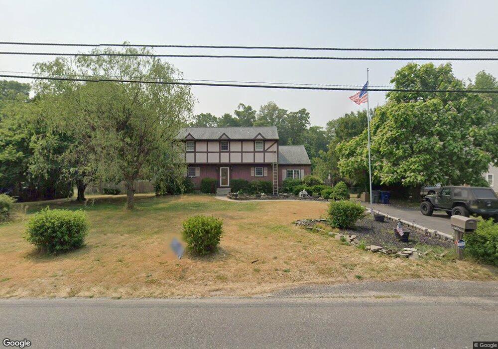
722 Grant Ave Franklinville, NJ 08322
Franklin Township NeighborhoodEstimated Value: $311,000 - $379,000
--
Bed
--
Bath
1,846
Sq Ft
$191/Sq Ft
Est. Value
About This Home
This home is located at 722 Grant Ave, Franklinville, NJ 08322 and is currently estimated at $352,191, approximately $190 per square foot. 722 Grant Ave is a home located in Gloucester County with nearby schools including Delsea Regional Middle School, Delsea Regional High School, and St Michael The Archangel Regional School.
Ownership History
Date
Name
Owned For
Owner Type
Purchase Details
Closed on
Aug 20, 2001
Sold by
First Union National Bank
Bought by
Pentek Ernest
Current Estimated Value
Home Financials for this Owner
Home Financials are based on the most recent Mortgage that was taken out on this home.
Original Mortgage
$95,900
Interest Rate
6.7%
Purchase Details
Closed on
Oct 20, 2000
Sold by
Venturini Patricia Lynn
Bought by
First Union National Bank
Purchase Details
Closed on
Jul 24, 1997
Sold by
Venturini Patricia Lynn and Venturini Louis J
Bought by
Venturini Patricia Lynn
Purchase Details
Closed on
Dec 7, 1994
Sold by
Venturini Patricia Lynn
Bought by
Venturini Patricia Lynn and Venturini Louis J
Create a Home Valuation Report for This Property
The Home Valuation Report is an in-depth analysis detailing your home's value as well as a comparison with similar homes in the area
Home Values in the Area
Average Home Value in this Area
Purchase History
| Date | Buyer | Sale Price | Title Company |
|---|---|---|---|
| Pentek Ernest | $119,900 | Fidelity National Title Ins | |
| First Union National Bank | $2,986 | -- | |
| Venturini Patricia Lynn | -- | -- | |
| Venturini Patricia Lynn | -- | -- |
Source: Public Records
Mortgage History
| Date | Status | Borrower | Loan Amount |
|---|---|---|---|
| Previous Owner | Pentek Ernest | $95,900 |
Source: Public Records
Tax History Compared to Growth
Tax History
| Year | Tax Paid | Tax Assessment Tax Assessment Total Assessment is a certain percentage of the fair market value that is determined by local assessors to be the total taxable value of land and additions on the property. | Land | Improvement |
|---|---|---|---|---|
| 2025 | $6,805 | $178,000 | $34,100 | $143,900 |
| 2024 | $6,648 | $178,000 | $34,100 | $143,900 |
| 2023 | $6,648 | $178,000 | $34,100 | $143,900 |
| 2022 | $6,469 | $178,000 | $34,100 | $143,900 |
| 2021 | $5,881 | $178,000 | $34,100 | $143,900 |
| 2020 | $6,310 | $178,000 | $34,100 | $143,900 |
| 2019 | $6,226 | $178,000 | $34,100 | $143,900 |
| 2018 | $6,145 | $178,000 | $34,100 | $143,900 |
| 2017 | $6,031 | $178,000 | $34,100 | $143,900 |
| 2016 | $6,002 | $178,000 | $34,100 | $143,900 |
| 2015 | $5,769 | $178,000 | $34,100 | $143,900 |
| 2014 | $5,555 | $178,000 | $34,100 | $143,900 |
Source: Public Records
Map
Nearby Homes
- 3198 Delsea Dr
- 3071 Delsea Dr
- 3328 Delsea Dr
- 893 Fries Mill Rd
- 919 Little Mill Rd
- 295 Blackwood Ave
- 237 S Delsea Dr
- 100 Jerrys Ave
- 196 Jerrys Ave
- 338 Sugar Hill Dr
- Lot 89 Delsea Dr
- 900 Delsea Dr
- 1780 Coles Mill Rd
- 7 Hawthorn Way
- 0 Fries Mill Rd
- 1800 Coles Mill Rd
- 18 Crysta Ct
- 320 E Clayton Ave
- 51 Elmer St
- 904 Pine Ave