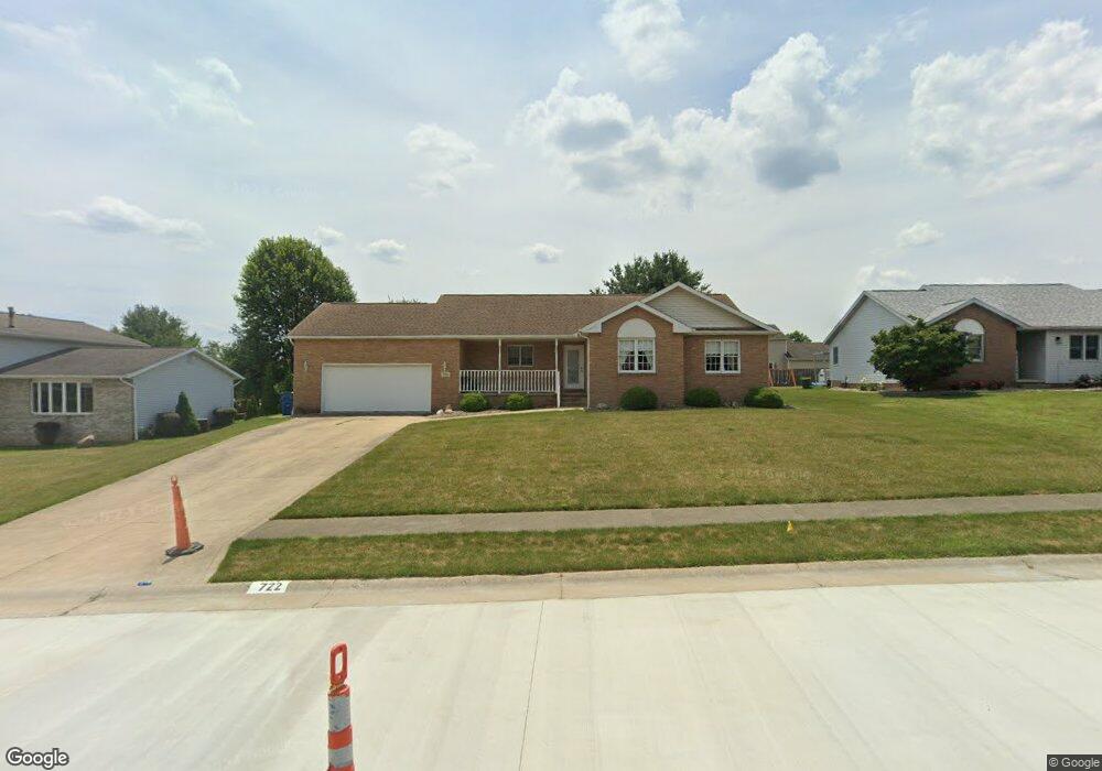
722 Joel Cir Louisville, OH 44641
Estimated Value: $250,890 - $280,000
3
Beds
3
Baths
1,423
Sq Ft
$186/Sq Ft
Est. Value
About This Home
This home is located at 722 Joel Cir, Louisville, OH 44641 and is currently estimated at $264,723, approximately $186 per square foot. 722 Joel Cir is a home located in Stark County with nearby schools including Louisville High School and St. Thomas Aquinas High School & Middle School.
Ownership History
Date
Name
Owned For
Owner Type
Purchase Details
Closed on
Jun 5, 2017
Bought by
Pagnucco Frances A & Joseph V Co T
Current Estimated Value
Purchase Details
Closed on
Feb 8, 2000
Sold by
Pagnucco and Frances
Bought by
Pagnucco Jerry A and Pagnucco Frances A
Purchase Details
Closed on
Jan 26, 1996
Sold by
Constitution Dev
Bought by
Pagnucco Jerry and Pagnucco Frances
Create a Home Valuation Report for This Property
The Home Valuation Report is an in-depth analysis detailing your home's value as well as a comparison with similar homes in the area
Home Values in the Area
Average Home Value in this Area
Purchase History
| Date | Buyer | Sale Price | Title Company |
|---|---|---|---|
| Pagnucco Frances A & Joseph V Co T | -- | -- | |
| Pagnucco Jerry A | -- | -- | |
| Pagnucco Jerry | $22,000 | -- |
Source: Public Records
Tax History Compared to Growth
Tax History
| Year | Tax Paid | Tax Assessment Tax Assessment Total Assessment is a certain percentage of the fair market value that is determined by local assessors to be the total taxable value of land and additions on the property. | Land | Improvement |
|---|---|---|---|---|
| 2025 | -- | $72,870 | $15,470 | $57,400 |
| 2024 | -- | $72,870 | $15,470 | $57,400 |
| 2023 | $2,204 | $60,450 | $12,810 | $47,640 |
| 2022 | $2,228 | $60,450 | $12,810 | $47,640 |
| 2021 | $2,234 | $60,450 | $12,810 | $47,640 |
| 2020 | $1,806 | $54,150 | $11,520 | $42,630 |
| 2019 | $1,814 | $56,570 | $11,520 | $45,050 |
| 2018 | $1,903 | $56,570 | $11,520 | $45,050 |
| 2017 | $1,761 | $51,450 | $9,660 | $41,790 |
| 2016 | $1,797 | $51,450 | $9,660 | $41,790 |
| 2015 | $1,803 | $51,450 | $9,660 | $41,790 |
| 2014 | $1,668 | $45,610 | $8,540 | $37,070 |
| 2013 | $841 | $45,610 | $8,540 | $37,070 |
Source: Public Records
Map
Nearby Homes
- 300 Kennedy St
- 1149 Sturbridge Dr
- 1175 Sturbridge Dr
- 614 Reno Dr
- 524 Glenbar St
- 428 Honeycrisp Dr NE
- 3047 Mcintosh Dr NE
- 432 Honeycrisp Dr NE
- 2962 Mcintosh Dr NE
- 2963 Mcintosh Dr NE
- 430 Honeycrisp Dr NE
- 2957 Mcintosh Dr NE
- 0 Brookridge Ave
- 0 Glenbar St
- 3580 Brookridge Ave Lot 15
- 5474 Ravenna Ave
- 316 E Reno Dr
- 325 Lincoln Ave
- 248 Menegay Rd
- 201 Indiana Ave
- 712 Joel Cir
- 721 Glencarlyn Ave
- 711 Glencarlyn Ave
- 731 Glencarlyn Ave
- 802 Joel Cir
- 702 Joel Cir
- 723 Joel Cir
- 713 Joel Cir
- 733 Joel Cir
- 801 Glencarlyn Ave
- 803 Joel Cir
- 703 Joel Cir
- 812 Joel Cir
- 811 Glencarlyn Ave
- 722 Glencarlyn Ave
- 712 Glencarlyn Ave
- 732 Glencarlyn Ave
- 822 Joel Cir
- 1078 Danielle Ave
- 813 Joel Cir