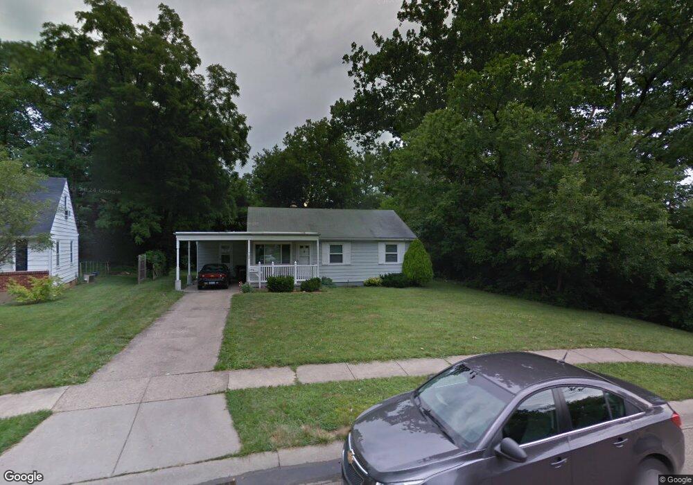
722 Springvale Dr Hamilton, OH 45013
Estimated Value: $197,990 - $214,000
3
Beds
1
Bath
1,044
Sq Ft
$197/Sq Ft
Est. Value
About This Home
This home is located at 722 Springvale Dr, Hamilton, OH 45013 and is currently estimated at $205,998, approximately $197 per square foot. 722 Springvale Dr is a home located in Butler County with nearby schools including Brookwood Elementary School, Wilson Middle School, and Hamilton High School Main Campus.
Ownership History
Date
Name
Owned For
Owner Type
Purchase Details
Closed on
Dec 29, 2014
Sold by
Staarmann Joseph and Staarmann Lynn
Bought by
Staarmann Joseph G and Staarmann Lynn A
Current Estimated Value
Purchase Details
Closed on
Apr 23, 2004
Sold by
Federal Home Loan Mortgage Corporation
Bought by
Staarmann Lynn and Staarmann Joseph
Purchase Details
Closed on
Mar 10, 2004
Sold by
Hamblin Timothy
Bought by
Federal Home Loan Mortgage Corporation
Purchase Details
Closed on
Oct 9, 1995
Sold by
Abeny Daniel E
Bought by
Hamblin Timothy S
Home Financials for this Owner
Home Financials are based on the most recent Mortgage that was taken out on this home.
Original Mortgage
$77,900
Interest Rate
7.91%
Mortgage Type
FHA
Purchase Details
Closed on
Jun 1, 1989
Create a Home Valuation Report for This Property
The Home Valuation Report is an in-depth analysis detailing your home's value as well as a comparison with similar homes in the area
Home Values in the Area
Average Home Value in this Area
Purchase History
| Date | Buyer | Sale Price | Title Company |
|---|---|---|---|
| Staarmann Joseph G | -- | None Available | |
| Staarmann Joseph G | -- | None Available | |
| Staarmann Lynn | -- | -- | |
| Federal Home Loan Mortgage Corporation | $90,000 | -- | |
| Hamblin Timothy S | $78,000 | -- | |
| -- | $52,000 | -- |
Source: Public Records
Mortgage History
| Date | Status | Borrower | Loan Amount |
|---|---|---|---|
| Previous Owner | Hamblin Timothy S | $77,900 |
Source: Public Records
Tax History
| Year | Tax Paid | Tax Assessment Tax Assessment Total Assessment is a certain percentage of the fair market value that is determined by local assessors to be the total taxable value of land and additions on the property. | Land | Improvement |
|---|---|---|---|---|
| 2025 | $2,081 | $48,040 | $10,130 | $37,910 |
| 2024 | $2,081 | $48,040 | $10,130 | $37,910 |
| 2023 | $2,071 | $49,130 | $10,130 | $39,000 |
| 2022 | $1,792 | $35,310 | $10,130 | $25,180 |
| 2021 | $1,592 | $34,250 | $10,130 | $24,120 |
| 2020 | $1,659 | $34,250 | $10,130 | $24,120 |
| 2019 | $2,072 | $28,300 | $10,180 | $18,120 |
| 2018 | $1,353 | $28,300 | $10,180 | $18,120 |
| 2017 | $1,365 | $28,300 | $10,180 | $18,120 |
| 2016 | $1,323 | $26,150 | $10,180 | $15,970 |
| 2015 | $1,316 | $26,150 | $10,180 | $15,970 |
| 2014 | $1,489 | $26,150 | $10,180 | $15,970 |
| 2013 | $1,489 | $31,500 | $10,180 | $21,320 |
Source: Public Records
Map
Nearby Homes
- 75 Berkshire Ct
- 570 Fairhaven Dr
- 30 Berkshire Ct
- 925 Carlisle Ave
- 824 Carlisle Ave
- 1102 Arbor Springs Dr
- 987 Carlisle Ave
- 540 Carlisle Ave
- 238 Twinbrook Dr
- 104 Chamberlin Dr
- 974 Westview Ave
- 64 Brookwood Ave
- 1326 Franklin St
- 205 Olympus Dr
- 1475 Diana Dr
- 30 S Washington Blvd
- 732 Millville Ave
- 936 Elizabeth Dr
- 146 Winston Dr
- 46 Lexington Dr
- 728 Springvale Dr
- 734 Springvale Dr
- 727 Springvale Dr
- 682 Springvale Dr
- 689 Fairhaven Dr
- 705 Fairhaven Dr
- 0 Rockford Dr
- 739 Springvale Dr
- 685 Fairhaven Dr
- 725 Fairhaven Dr
- 670 Springvale Dr
- 671 Fairhaven Dr
- 745 Fairhaven Dr
- 5 Rockford Dr
- 747 Springvale Dr
- 643 Fairhaven Dr
- 658 Springvale Dr
- 15 Rockford Dr
- 744 Springvale Dr
- 751 Springvale Dr
Your Personal Tour Guide
Ask me questions while you tour the home.