$489,900

7220 E 1900 S Panguitch, UT 84759

Estimated payment $2,588/month

Total Views 10,496
24.06 Acres
$20,362 Price per Acre
1,048,054 Sq Ft Lot

Highlights

  • 24.06 Acre Lot
  • No HOA
  • Brush Vegetation
  • Pine Trees
  • Property is near a preserve or public land
  • Level Lot

About This Lot

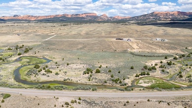
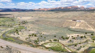
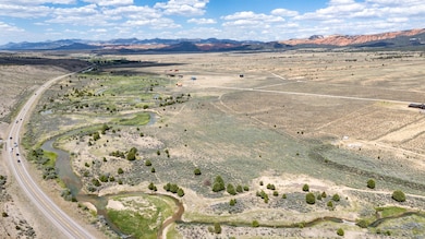
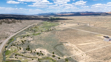
Discover the perfect blend of privacy, accessibility, & natural beauty with this extraordinary 24-acre parcel of land, nestled along the scenic Sevier River. Boasting easy year-round access just off HWY 89, bordering BLM Land on the South and East sides. this one-of-a-kind property offers unparalleled opportunities for both recreation and relaxation. Enjoy direct access to the Sevier River as it runs through the property, perfect for fishing, kayaking, or simply soaking in the tranquil sounds of flowing water. The South & East boundaries of the property adjoin BLM land, ensuring your privacy & preserving the pristine natural surroundings. Immerse yourself in the breathtaking vistas that stretch in every direction, featuring rolling hills, lush landscapes, & picturesque river views.

Listing Agent

Jennifer Davis

ERA Realty Center License #5458788-AB00 Listed on: 01/17/2025

ERA Realty Center

Property Details

Property Type

  • Land

Est. Annual Taxes

  • $10

Lot Details

  • 24.06 Acre Lot
  • Road Access Is Seasonal
  • Brush Vegetation
  • Native Plants
  • Level Lot
  • Pine Trees
  • Property is zoned R-20

Community Details

  • No Home Owners Association
  • Property is near a preserve or public land

Listing and Financial Details

  • Assessor Parcel Number 16-0081-1456

Property Details

Property Type

Land

Est. Annual Taxes

$10

Lot Details

0

Listing Details

  • Directions: From HWY 89 turn on Old Hillsdale Rd., turn right (South) on Elkhorn Road follow to 7100 S., turn left on 1900 S. for about 1/4 mile.
  • Prop. Type: Land
  • Reso Property Sub Type: Lot
  • Road Surface Type: Seasonal
  • Subdivision Name: Not Applicable
  • Master Plan Zoning: R-20
  • Terrain Flat: Yes
  • Accessibility Seasonal: Yes
  • Utilities Electric-City: Yes
  • VegetationCrops:Natural Grass: Yes
  • VegetationCrops:Sage Brush: Yes
  • VegetationCrops:Trees-Pine: Yes
  • VegetationCrops:Native Vegetation: Yes
  • Accessibility Adjacent to Public Lands: Yes
  • Special Features: None
  • Property Sub Type: LotsLands

Exterior Features

  • Acres: 24.06
  • Exterior Features: Fence

Condo/Co-op/Association

  • Senior Community: No
  • Association: No

Lot Info

  • Parcel #: 16-0081-1456
  • Lot Size Sq Ft: 1048053.6
  • ResoLotSizeUnits: Acres

Tax Info

  • Tax Annual Amount: 9.89

Map

Range of Values:

Collateral Analytics

Collateral Analytics Collateral Analytics AVMs (Automated Valuation Model) employ a number of statistical approaches combined with neighborhood-specific comparable selection guarantees the most up-to-date and precise valuations.

Not Available

Collateral Analytics does not have data for the current month. Please view the chart for historical values.

ICE

ICE Mortgage Technology ICE Mortgage Technology’s AVM (Automated Valuation Model) is a state-of-the-art online residential property valuation tool that provides a quick and accurate estimate of the value of almost any home in the U.S.

Not Available

ICE Mortgage Technology does not have data for the current month. Please view the chart for historical values.

First American

First American First American Data & Analytics’ next-generation AVM combines unrivaled data assets with a blended ensemble of valuation models to produce highly accurate, reliable valuations you can trust.

Not Available

First American does not have data for the current month. Please view the chart for historical values.

Quantarium

Quantarium Quantarium’s valuation service, repeatedly proven the industry’s most accurate and comprehensive, is supercharged with a self-learning and auto-tuning AI engine that continually becomes smarter and more accurate as it processes daily inputs from the industry’s leading RE data lake.

Not Available

Quantarium does not have data for the current month. Please view the chart for historical values.

Average Value
Not Available
List Price
Sold Price
Create a Home Valuation Report for This Property
The Home Valuation Report is an in-depth analysis detailing your home's value as well as a comparison with similar homes in the area

Home Values in the Area

Source: Public Records

Average Home Value in this Area


Source: Public Records

Tax History

Year Tax Paid Tax Assessment Tax Assessment Total Assessment is a certain percentage of the fair market value that is determined by local assessors to be the total taxable value of land and additions on the property. Land Improvement
2024 $10 $38,496 $38,496 $0
2023 $12 $38,496 $38,496 $0
2022 $12 $36,090 $36,090 $0
2021 $12 $36,090 $36,090 $0
2020 $12 $36,090 $36,090 $0
2019 $13 $36,090 $36,090 $0
2018 $16 $1,901 $0 $0
2017 $16 $1,901 $0 $0
2016 $16 $1,901 $0 $0
2015 $16 $1,901 $0 $0
2012 $16 $1,587 $0 $0
Source: Public Records

Property History

Date Event Price Change Sq Ft Price
01/17/2025 01/17/25 For Sale $489,900 -- --
Source: Iron County Board of REALTORS®

Source: Iron County Board of REALTORS®

MLS Number: 109626

APN: 16-0081-1456