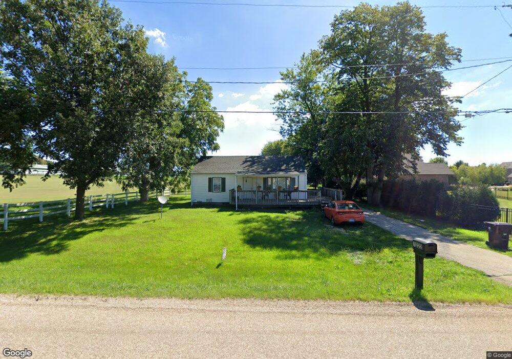
7222 N Koerner Rd Peoria, IL 61615
North Peoria NeighborhoodEstimated Value: $129,000 - $551,000
4
Beds
1
Bath
925
Sq Ft
$304/Sq Ft
Est. Value
About This Home
This home is located at 7222 N Koerner Rd, Peoria, IL 61615 and is currently estimated at $280,848, approximately $303 per square foot. 7222 N Koerner Rd is a home with nearby schools including Ridgeview Elementary School, Dunlap Valley Middle School, and Dunlap High School.
Ownership History
Date
Name
Owned For
Owner Type
Purchase Details
Closed on
Mar 8, 2017
Sold by
Armstrong Builders Of Peoria Inc
Bought by
Weaver Farm Homestead Llc
Current Estimated Value
Purchase Details
Closed on
Jan 26, 2017
Sold by
Armstrong Builders Of Peoria Inc
Bought by
Weaver Farm Homestead Llc
Purchase Details
Closed on
Jun 20, 2000
Bought by
Weaver Farms Limited Partnership
Create a Home Valuation Report for This Property
The Home Valuation Report is an in-depth analysis detailing your home's value as well as a comparison with similar homes in the area
Home Values in the Area
Average Home Value in this Area
Purchase History
| Date | Buyer | Sale Price | Title Company |
|---|---|---|---|
| Weaver Farm Homestead Llc | -- | Endeavor Title Agency Inc | |
| Weaver Farm Homestead Llc | -- | Endeavor Title Agency Inc | |
| Weaver Farms Limited Partnership | $1,000 | -- |
Source: Public Records
Tax History Compared to Growth
Tax History
| Year | Tax Paid | Tax Assessment Tax Assessment Total Assessment is a certain percentage of the fair market value that is determined by local assessors to be the total taxable value of land and additions on the property. | Land | Improvement |
|---|---|---|---|---|
| 2024 | $1,466 | $16,700 | $15,500 | $1,200 |
| 2023 | $1,344 | $15,180 | $14,090 | $1,090 |
| 2022 | $1,261 | $14,140 | $13,110 | $1,030 |
| 2021 | $1,225 | $13,600 | $12,610 | $990 |
| 2020 | $1,234 | $13,600 | $12,610 | $990 |
| 2019 | $1,232 | $13,600 | $12,610 | $990 |
| 2018 | $1,197 | $13,340 | $12,850 | $490 |
| 2017 | $3,099 | $34,460 | $13,110 | $21,350 |
| 2016 | $2,992 | $34,460 | $13,110 | $21,350 |
| 2015 | $2,904 | $33,140 | $12,610 | $20,530 |
| 2014 | $2,868 | $33,410 | $12,720 | $20,690 |
| 2013 | -- | $33,080 | $12,590 | $20,490 |
Source: Public Records
Map
Nearby Homes
- 6004 W Woodbridge Place
- 7027 N Buckeye Dr
- 7124 N Ironwood Dr
- 6426 Ironwood Dr
- 6417 W Ironwood Dr
- 6401 W Callahan Ct
- 6411 W Callahan Ct
- 6412 W Callahan Ct
- 6521 N Ironwood Dr
- 6623 N Ironwood Dr
- 6505 N Ironwood Dr
- 6512 N Ironwood Dr
- 6419 Callahan Ct
- 6917 N Flagstone Ct
- 6501 W Callahan Ct
- 6414 W Hazel Nut Dr
- 6509 Callahan Ct
- 5413 W Briarstone Dr
- 6616 N Ironwood Dr
- 7024 N Water Oak Dr
- 5919 W Ivybridge Place
- 5911 W Ivybridge Place
- 6001 W Ivybridge Place
- 6001 W Ivybridge Place Unit L
- 5903 W Ivybridge Place
- LOT 46 W Ivybridge Place
- LOT 47 W Ivybridge Place
- LOT 49 W Ivybridge Place
- 7220 N Wescott Ct
- 6011 W Ivybridge Place
- 7221 N Drake Ct
- 7221 N Wescott Ct
- 5811 W Ivybridge Place
- 6017 W Ivybridge Place
- LOT 83 N Drake Ct
- LOT 87 N Drake Ct
- LOT 82 N Drake Ct
- 7212 N Wescott Ct
- 7220 N Drake Ct
- 7215 N Drake Ct