
Seller's Agent in 2026
Marcia Mitchell
HomeSmart
(470) 844-6053
1 in this area
15 Total Sales
Estimated Value: $160,000 - $164,000
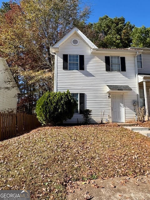
Welcome home to this beautifully updated 1,208 SqFt end-unit townhome, perfectly situated just minutes from Six Flags Over Georgia and convenient to major highways, shopping, and dining. Featuring two spacious bedroom suites, each with its own private bath, plus a guest half bath on the main level, this layout is ideal for comfort and functionality. Step inside to a warm and inviting living room highlighted by a cozy gas-log fireplace, perfect for relaxing evenings. The main level flows into a bright kitchen with new matching cabinetry carried throughout the kitchen and all bathrooms. The home also boasts luxury laminate flooring, offering both style and durability. Additional features include: End-unit for added privacy Updated finishes throughout Move-in-ready condition This well-maintained townhome is an excellent opportunity for first-time buyers, investors, or anyone seeking low-maintenance living in a prime location. Schedule your showing today!
Last Agent to Sell the Property
HomeSmart Brokerage Phone: 470-844-6053 License #418960 Listed on: 11/28/2025
We collect this data history from publicly available records. To have your information removed, we recommend requesting removal directly through your county’s website.
We collect this data history from publicly available records. To have your information removed, we recommend requesting removal directly through your county’s website.
| Date | Buyer | Sale Price | Title Company |
|---|---|---|---|
| $165,000 | None Listed On Document | ||
| $86,000 | -- |
We collect this data history from publicly available records. To have your information removed, we recommend requesting removal directly through your county’s website.
| Date | Status | Borrower | Loan Amount |
|---|---|---|---|
| Open | $8,250 | ||
| Open | $162,011 | ||
| Previous Owner | $81,700 |
We collect this data history from publicly available records. To have your information removed, we recommend requesting removal directly through your county’s website.
| Date | Event | Price | List to Sale | Price per Sq Ft |
|---|---|---|---|---|
| 02/13/2026 02/13/26 | Sold | $165,000 | 0.0% | $129 / Sq Ft |
| 01/08/2026 01/08/26 | Pending | -- | -- | -- |
| 11/28/2025 11/28/25 | For Sale | $165,000 | -- | $129 / Sq Ft |
We collect this data history from publicly available records. To have your information removed, we recommend requesting removal directly through your county’s website.
| Year | Tax Paid | Tax Assessment Tax Assessment Total Assessment is a certain percentage of the fair market value that is determined by local assessors to be the total taxable value of land and additions on the property. | Land | Improvement |
|---|---|---|---|---|
| 2025 | $1,502 | $49,844 | $11,200 | $38,644 |
| 2024 | $1,786 | $59,228 | $11,200 | $48,028 |
| 2023 | $1,478 | $49,024 | $6,000 | $43,024 |
| 2022 | $1,488 | $49,024 | $6,000 | $43,024 |
| 2021 | $795 | $26,184 | $3,200 | $22,984 |
| 2020 | $795 | $26,184 | $3,200 | $22,984 |
| 2019 | $795 | $26,184 | $3,200 | $22,984 |
| 2018 | $748 | $24,660 | $3,200 | $21,460 |
| 2017 | $527 | $18,316 | $3,200 | $15,116 |
| 2016 | $472 | $16,428 | $3,200 | $13,228 |
| 2015 | $404 | $13,716 | $2,800 | $10,916 |
| 2014 | $408 | $13,716 | $0 | $0 |
Seller's Agent in 2026
Marcia Mitchell
HomeSmart
(470) 844-6053
1 in this area
15 Total Sales
Buyer's Agent in 2026
Lexus Henry
Keller Williams West Atlanta
(248) 421-7403
1 in this area
2 Total Sales
Source: Georgia MLS
MLS Number: 10650419
APN: 18-0588-0-101-0
Disclaimer: Certain information contained herein is derived from information provided by parties other than Homes.com. All information provided is deemed reliable, but is not guaranteed to be accurate and should be independently verified.
![]() The data relating to real estate for sale on this web site comes in part from the Broker Reciprocity Program of Georgia MLS. Real estate listings held by brokerage firms other than Redfin are marked with the Broker Reciprocity logo and detailed information about them includes the name of the listing brokers. Information deemed reliable but not guaranteed. Copyright 2026 Georgia MLS. All rights reserved.
The data relating to real estate for sale on this web site comes in part from the Broker Reciprocity Program of Georgia MLS. Real estate listings held by brokerage firms other than Redfin are marked with the Broker Reciprocity logo and detailed information about them includes the name of the listing brokers. Information deemed reliable but not guaranteed. Copyright 2026 Georgia MLS. All rights reserved.
Ask me questions while you tour the home.