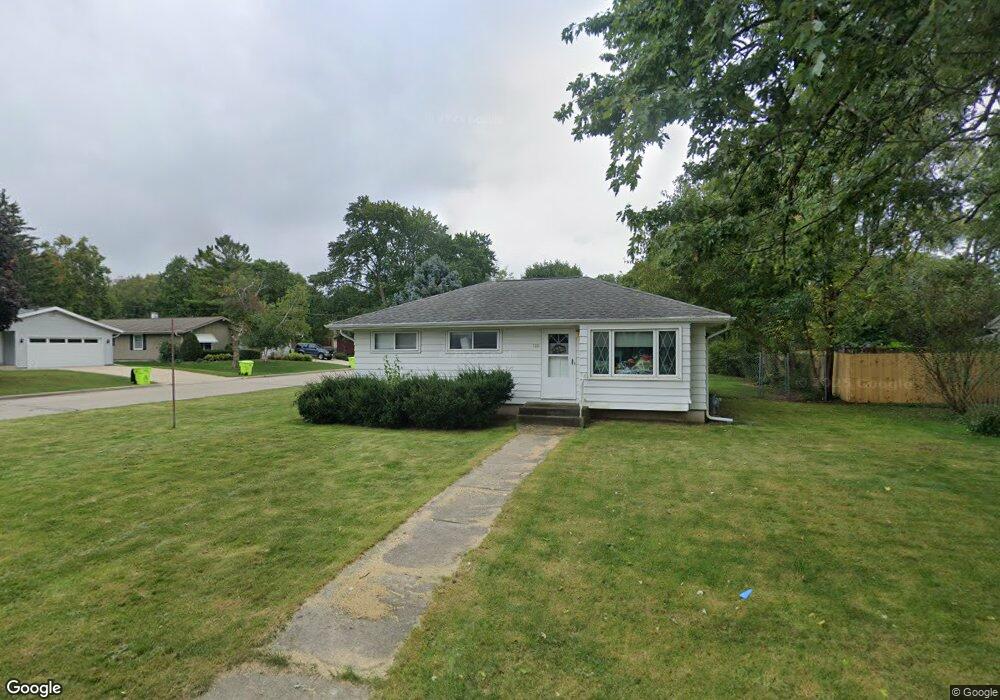
723 Belshire Dr Hartland, WI 53029
Estimated Value: $347,849 - $372,000
3
Beds
1
Bath
884
Sq Ft
$404/Sq Ft
Est. Value
About This Home
This home is located at 723 Belshire Dr, Hartland, WI 53029 and is currently estimated at $356,712, approximately $403 per square foot. 723 Belshire Dr is a home located in Waukesha County with nearby schools including Arrowhead High School, St Charles Parish School, and Zion Lutheran School.
Ownership History
Date
Name
Owned For
Owner Type
Purchase Details
Closed on
Apr 27, 2006
Sold by
Bannister Jeffrey R and Bannister Katie A
Bought by
Culhane Timothy J and Culhane James P
Current Estimated Value
Home Financials for this Owner
Home Financials are based on the most recent Mortgage that was taken out on this home.
Original Mortgage
$100,000
Outstanding Balance
$58,378
Interest Rate
6.54%
Mortgage Type
Purchase Money Mortgage
Estimated Equity
$298,334
Purchase Details
Closed on
Jun 14, 2002
Sold by
Kachelmeyer George M and Kachelmeyer Patricia J
Bought by
Bannister Jeffrey R and Bannister Katie A
Home Financials for this Owner
Home Financials are based on the most recent Mortgage that was taken out on this home.
Original Mortgage
$127,400
Interest Rate
6.93%
Mortgage Type
Purchase Money Mortgage
Create a Home Valuation Report for This Property
The Home Valuation Report is an in-depth analysis detailing your home's value as well as a comparison with similar homes in the area
Home Values in the Area
Average Home Value in this Area
Purchase History
| Date | Buyer | Sale Price | Title Company |
|---|---|---|---|
| Culhane Timothy J | $198,000 | None Available | |
| Bannister Jeffrey R | $149,900 | -- |
Source: Public Records
Mortgage History
| Date | Status | Borrower | Loan Amount |
|---|---|---|---|
| Open | Culhane Timothy J | $100,000 | |
| Previous Owner | Bannister Jeffrey R | $127,400 |
Source: Public Records
Tax History Compared to Growth
Tax History
| Year | Tax Paid | Tax Assessment Tax Assessment Total Assessment is a certain percentage of the fair market value that is determined by local assessors to be the total taxable value of land and additions on the property. | Land | Improvement |
|---|---|---|---|---|
| 2024 | $2,697 | $262,600 | $72,200 | $190,400 |
| 2023 | $2,521 | $262,600 | $72,200 | $190,400 |
| 2022 | $2,424 | $200,100 | $60,100 | $140,000 |
| 2021 | $2,458 | $200,100 | $60,100 | $140,000 |
| 2020 | $2,475 | $200,100 | $60,100 | $140,000 |
| 2019 | $2,492 | $200,100 | $60,100 | $140,000 |
| 2018 | $2,596 | $181,300 | $62,000 | $119,300 |
| 2017 | $2,726 | $181,300 | $62,000 | $119,300 |
| 2016 | $2,825 | $181,300 | $62,000 | $119,300 |
| 2015 | $2,958 | $181,300 | $62,000 | $119,300 |
| 2014 | $2,862 | $181,300 | $62,000 | $119,300 |
| 2013 | $2,862 | $180,100 | $59,000 | $121,100 |
Source: Public Records
Map
Nearby Homes
- 286 Hazel Ln
- 447 Merton Ave
- 508 Merton Ave
- 901 Anton Rd
- 1117 Sweetbriar Ln Unit 22
- 459 Sunset Trail Unit 2
- 1600 E Juniper Way
- 345 Cottonwood Ave
- 1702 E Juniper Way
- 222 Granary Cir
- 1800 E Juniper Way
- 733 Cardiff Ct
- 310 Paradise Ct
- W305N5260 Gail Ln
- N53W30509 Arrowhead Dr
- 328 Hemlock Ct
- 1012 N Bluespruce Cir
- Pcl2 Hill St
- 902 N Bluespruce Cir
- W289N4159 Farm Valley Ct