Estimated Value: $320,000 - $343,000
3
Beds
2
Baths
1,526
Sq Ft
$216/Sq Ft
Est. Value
About This Home
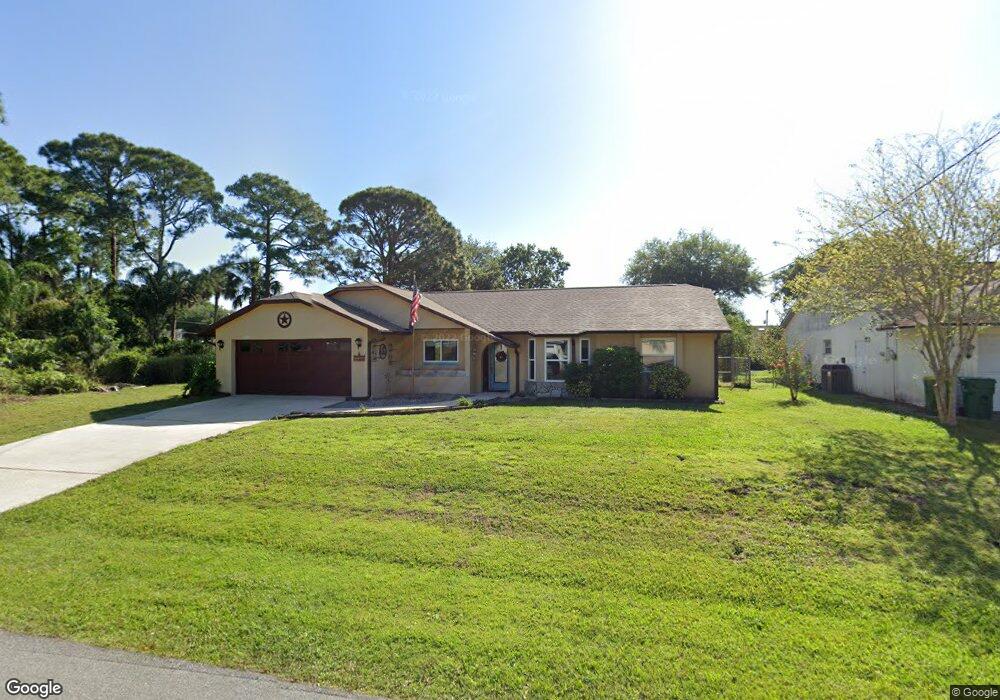
This home is located at 7235 Kimball Ave, Cocoa, FL 32927 and is currently estimated at $329,733, approximately $216 per square foot. 7235 Kimball Ave is a home located in Brevard County with nearby schools including Enterprise Elementary School, Space Coast Junior/Senior High School, and East Atlantic Prep of Brevard County.
Ownership History
Date
Name
Owned For
Owner Type
Purchase Details
Closed on
Mar 25, 2020
Sold by
Perez David R and Perez Pia M
Bought by
Launch Federal Credit Union
Current Estimated Value
Home Financials for this Owner
Home Financials are based on the most recent Mortgage that was taken out on this home.
Original Mortgage
$104,000
Outstanding Balance
$91,931
Interest Rate
3.4%
Mortgage Type
New Conventional
Estimated Equity
$237,802
Create a Home Valuation Report for This Property
The Home Valuation Report is an in-depth analysis detailing your home's value as well as a comparison with similar homes in the area
Home Values in the Area
Average Home Value in this Area
Purchase History
| Date | Buyer | Sale Price | Title Company |
|---|---|---|---|
| Launch Federal Credit Union | -- | Fidelity National Title |
Source: Public Records
Mortgage History
| Date | Status | Borrower | Loan Amount |
|---|---|---|---|
| Open | Launch Federal Credit Union | $104,000 |
Source: Public Records
Tax History
| Year | Tax Paid | Tax Assessment Tax Assessment Total Assessment is a certain percentage of the fair market value that is determined by local assessors to be the total taxable value of land and additions on the property. | Land | Improvement |
|---|---|---|---|---|
| 2025 | $1,500 | $115,190 | -- | -- |
| 2024 | $1,461 | $111,950 | -- | -- |
| 2023 | $1,461 | $108,690 | $0 | $0 |
| 2022 | $1,416 | $105,530 | $0 | $0 |
| 2021 | $1,418 | $102,460 | $0 | $0 |
| 2020 | $1,363 | $101,050 | $0 | $0 |
| 2019 | $1,300 | $98,780 | $0 | $0 |
| 2018 | $1,293 | $96,940 | $0 | $0 |
| 2017 | $1,288 | $94,950 | $0 | $0 |
| 2016 | $1,291 | $93,000 | $18,000 | $75,000 |
| 2015 | $1,308 | $92,360 | $15,000 | $77,360 |
| 2014 | $1,310 | $91,630 | $11,000 | $80,630 |
Source: Public Records
Map
Nearby Homes
- 7200 Oakwood Ave
- 7368 Crepe Myrtle Ct
- 7419 Hackberry Rd
- 7429 Hackberry Rd
- 7230 Venus Ave
- 5680 Brandon St
- 7635 Fringe Place
- 7606 Fringe Place
- 5555 Brandon St
- 7065 Hundred Acre Dr
- 6990 Bryant Rd
- 5303 Yaupon Holly Dr
- 5242 Yaupon Holly Dr
- 5165 Patricia St
- 6815 Bryant Rd
- 5150 Melody St
- 5155 Mayflower St
- 5200 Frisco St
- 6760 Cairo Rd
- 6581 Bancroft Ave
- 5695 Friendly St
- 7230 Milton Ave
- 7215 Kimball Ave
- 7220 Milton Ave
- 7210 Milton
- 7240 Kimball Ave
- 7230 Kimball Ave
- 5685 Friendly St
- 7250 Kimball Ave
- 7205 Kimball Ave
- 5710 Friendly St
- 5700 Friendly St
- 5720 Friendly St
- 5690 Friendly St Unit 7
- 7245 Freeport Rd
- 7235 Freeport Rd
- 5665 Friendly St
- 7255 Freeport Rd
- 7235 Milton Ave Unit 7
- 7235 Milton Ave
Your Personal Tour Guide
Ask me questions while you tour the home.