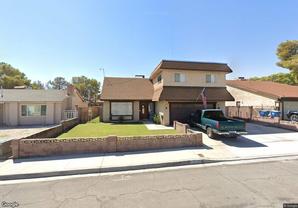
7237 Enterprise Dr Las Vegas, NV 89147
Estimated Value: $441,000 - $471,000
5
Beds
3
Baths
2,202
Sq Ft
$204/Sq Ft
Est. Value
About This Home
This home is located at 7237 Enterprise Dr, Las Vegas, NV 89147 and is currently estimated at $449,114, approximately $203 per square foot. 7237 Enterprise Dr is a home located in Clark County with nearby schools including Frank Kim Elementary School, Clifford J Lawrence Junior High School, and Durango High School.
Ownership History
Date
Name
Owned For
Owner Type
Purchase Details
Closed on
Jul 27, 2023
Sold by
Anstett Thomas B and Anstett Rebecca T
Bought by
Osburn Cheyenne Rebecca and Harris Slater Lee
Current Estimated Value
Home Financials for this Owner
Home Financials are based on the most recent Mortgage that was taken out on this home.
Original Mortgage
$15,000
Outstanding Balance
$14,651
Interest Rate
6.69%
Estimated Equity
$434,464
Purchase Details
Closed on
Oct 3, 2005
Sold by
Anstett Thomas B
Bought by
Ansteit Thomas B and Anstett Rebecca T
Create a Home Valuation Report for This Property
The Home Valuation Report is an in-depth analysis detailing your home's value as well as a comparison with similar homes in the area
Home Values in the Area
Average Home Value in this Area
Purchase History
| Date | Buyer | Sale Price | Title Company |
|---|---|---|---|
| Osburn Cheyenne Rebecca | $365,000 | Old Republic Title | |
| Ansteit Thomas B | -- | -- |
Source: Public Records
Mortgage History
| Date | Status | Borrower | Loan Amount |
|---|---|---|---|
| Open | Osburn Cheyenne Rebecca | $15,000 | |
| Open | Osburn Cheyenne Rebecca | $356,125 |
Source: Public Records
Tax History Compared to Growth
Tax History
| Year | Tax Paid | Tax Assessment Tax Assessment Total Assessment is a certain percentage of the fair market value that is determined by local assessors to be the total taxable value of land and additions on the property. | Land | Improvement |
|---|---|---|---|---|
| 2025 | $1,575 | $71,080 | $38,150 | $32,930 |
| 2024 | $1,529 | $71,080 | $38,150 | $32,930 |
| 2023 | $1,529 | $66,082 | $33,250 | $32,832 |
| 2022 | $1,394 | $59,023 | $28,350 | $30,673 |
| 2021 | $1,356 | $55,365 | $25,550 | $29,815 |
| 2020 | $1,312 | $54,682 | $24,500 | $30,182 |
| 2019 | $1,274 | $53,058 | $22,750 | $30,308 |
| 2018 | $1,237 | $50,017 | $20,650 | $29,367 |
| 2017 | $1,352 | $48,740 | $18,550 | $30,190 |
| 2016 | $1,171 | $44,877 | $13,650 | $31,227 |
| 2015 | $1,169 | $42,126 | $10,850 | $31,276 |
| 2014 | $1,134 | $39,958 | $8,400 | $31,558 |
Source: Public Records
Map
Nearby Homes
- 4826 Castle Rock Ct
- 7296 Mission Hills Dr
- 7137 Enterprise Dr
- 7211 Mission Hills Dr
- 7132 Mission Hills Dr
- 7363 Mission Hills Dr
- 7131 Mission Hills Dr
- 7139 Mission Hills Dr
- 7024 Bright Springs Ct
- 4766 Knollwood Dr
- 7157 Mission Hills Dr
- 7068 Bright Springs Ct
- 4772 Yorkfield Cir
- 7061 Bright Springs Ct
- 7012 Bright Springs Ct
- 6902 Emerald Springs Ln
- 4844 Treetrunk Ave
- 6976 Emerald Springs Ln
- 7047 Mountain Meadow Ln
- 6974 Emerald Springs Ln
- 7247 Enterprise Dr
- 7227 Enterprise Dr
- 7227 Enterprise Dr Unit n/a
- 7217 Enterprise Dr
- 7257 Enterprise Dr
- 7236 Enterprise Dr
- 7226 Enterprise Dr
- 7207 Enterprise Dr
- 7267 Enterprise Dr
- 7246 Enterprise Dr
- 7216 Enterprise Dr
- 4858 Ashbrook Place
- 7269 Mission Hills Dr
- 7197 Enterprise Dr
- 7206 Enterprise Dr
- 7251 Mission Hills Dr
- 7237 Southpark Ct
- 7277 Enterprise Dr
- 7227 Southpark Ct
- 4848 Ashbrook Place