Estimated Value: $162,000
Studio
--
Bath
38
Sq Ft
$4,263/Sq Ft
Est. Value
About This Home
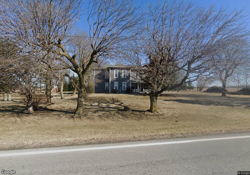
This home is located at 7237 State Route 701, Ada, OH 45810 and is currently estimated at $162,000, approximately $4,263 per square foot. 7237 State Route 701 is a home located in Hardin County with nearby schools including Hardin Northern Elementary School and Hardin Northern High School.
Ownership History
Date
Name
Owned For
Owner Type
Purchase Details
Closed on
Sep 25, 2020
Current Estimated Value
Home Financials for this Owner
Home Financials are based on the most recent Mortgage that was taken out on this home.
Interest Rate
2.9%
Purchase Details
Closed on
Mar 20, 2020
Sold by
Mcneal Jan C
Bought by
Arthur Charron Stephen and Arthur Jean Charron
Purchase Details
Closed on
Feb 24, 2006
Sold by
Mcneal Jan C and Mcneal Mary A
Bought by
Charron Stephen Arthur and Charron Dianna Jean
Create a Home Valuation Report for This Property
The Home Valuation Report is an in-depth analysis detailing your home's value as well as a comparison with similar homes in the area
Purchase History
| Date | Buyer | Sale Price | Title Company |
|---|---|---|---|
| -- | $244,000 | -- | |
| Arthur Charron Stephen | -- | None Available | |
| Charron Stephen Arthur | $16,000 | None Available |
Source: Public Records
Mortgage History
| Date | Status | Borrower | Loan Amount |
|---|---|---|---|
| Closed | -- | -- |
Source: Public Records
Tax History
| Year | Tax Paid | Tax Assessment Tax Assessment Total Assessment is a certain percentage of the fair market value that is determined by local assessors to be the total taxable value of land and additions on the property. | Land | Improvement |
|---|---|---|---|---|
| 2024 | $89 | $2,330 | $1,640 | $690 |
| 2023 | $87 | $2,330 | $1,640 | $690 |
| 2022 | $71 | $1,450 | $990 | $460 |
| 2021 | $73 | $1,450 | $990 | $460 |
| 2020 | $72 | $1,450 | $990 | $460 |
| 2019 | $66 | $1,450 | $990 | $460 |
| 2018 | $66 | $1,450 | $990 | $460 |
| 2017 | $36 | $1,450 | $990 | $460 |
| 2016 | $68 | $1,520 | $990 | $530 |
| 2015 | $60 | $1,520 | $990 | $530 |
| 2014 | $38 | $1,520 | $990 | $530 |
| 2013 | $42 | $1,520 | $990 | $530 |
Source: Public Records
Map
Nearby Homes
- 501 Elm St
- 407 Marion St
- 403 Marion St
- 2864 Ohio 309
- 318 Willeke Ave
- 2375 Wayne St
- 314 E University Ave
- 820 S Main St
- 710 S Main St
- 308-310 S Simon St
- 5262 County Road 135
- 442 Edwards St
- 503 E North Ave
- 211 S Main St
- 210 N Gilbert St
- 746 N Main St Unit 61
- 746 N Main St Unit 63
- 746 N Main St Unit 74
- 746 N Main St Unit 9
- 746 N Main St Unit 35
- 7237 State Route 701
- 7237 St Route
- 7415 State Route 701
- 5790 Township Road 85
- 5790 Tr 85
- 7815 State Route 701
- 6349 State Route 701
- 6045 County Road 95
- 6136 County Road 95
- 8586 State Route 701
- 5655 County Road 95
- 6280 County Road 95
- 5377 County Road 95
- 0 County Road 95
- 6445 Co Rd
- 6495 County Road 95
- 5517 County Road 95
- 0 Hensel Rd
- 6612 County Road 95
- 7110 County Road 60
Your Personal Tour Guide
Ask me questions while you tour the home.