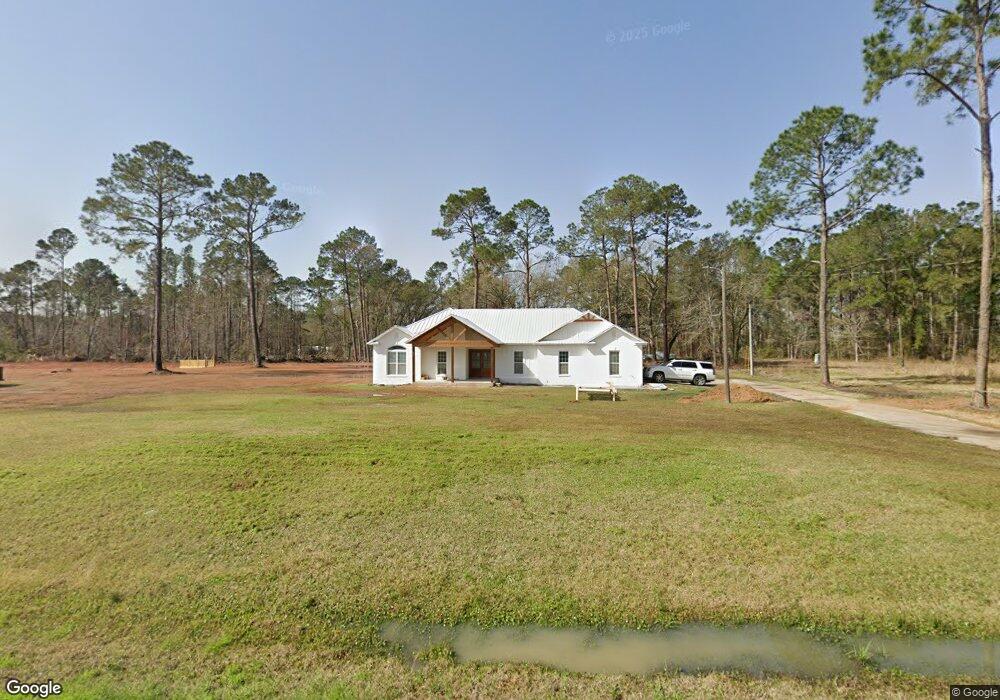
7241 Simpson Rd Hahira, GA 31632
Estimated Value: $285,096 - $298,000
3
Beds
2
Baths
1,870
Sq Ft
$155/Sq Ft
Est. Value
About This Home
This home is located at 7241 Simpson Rd, Hahira, GA 31632 and is currently estimated at $290,524, approximately $155 per square foot. 7241 Simpson Rd is a home located in Lowndes County with nearby schools including Hahira Elementary School, Hahira Middle School, and Lowndes High School.
Ownership History
Date
Name
Owned For
Owner Type
Purchase Details
Closed on
Nov 6, 2009
Sold by
Davis Shannon
Bought by
Davis Shannon and Farrell Eric
Current Estimated Value
Home Financials for this Owner
Home Financials are based on the most recent Mortgage that was taken out on this home.
Original Mortgage
$141,200
Outstanding Balance
$91,820
Interest Rate
4.92%
Mortgage Type
New Conventional
Estimated Equity
$198,704
Purchase Details
Closed on
Jun 5, 2009
Sold by
Coxfield Michael A
Bought by
S K R Properties Llc
Purchase Details
Closed on
Apr 29, 1988
Bought by
Coxfield Michael A
Create a Home Valuation Report for This Property
The Home Valuation Report is an in-depth analysis detailing your home's value as well as a comparison with similar homes in the area
Home Values in the Area
Average Home Value in this Area
Purchase History
| Date | Buyer | Sale Price | Title Company |
|---|---|---|---|
| Davis Shannon | -- | -- | |
| Davis Shannon | $138,376 | -- | |
| S K R Properties Llc | -- | -- | |
| Coxfield Michael A | $12,600 | -- |
Source: Public Records
Mortgage History
| Date | Status | Borrower | Loan Amount |
|---|---|---|---|
| Open | Davis Shannon | $141,200 |
Source: Public Records
Tax History Compared to Growth
Tax History
| Year | Tax Paid | Tax Assessment Tax Assessment Total Assessment is a certain percentage of the fair market value that is determined by local assessors to be the total taxable value of land and additions on the property. | Land | Improvement |
|---|---|---|---|---|
| 2024 | $1,997 | $84,896 | $6,478 | $78,418 |
| 2023 | $1,882 | $84,472 | $6,054 | $78,418 |
| 2022 | $1,603 | $63,484 | $6,054 | $57,430 |
| 2021 | $1,674 | $63,484 | $6,054 | $57,430 |
| 2020 | $1,553 | $63,440 | $6,010 | $57,430 |
| 2019 | $1,569 | $63,440 | $6,010 | $57,430 |
| 2018 | $1,586 | $63,440 | $6,010 | $57,430 |
| 2017 | $1,597 | $62,894 | $5,464 | $57,430 |
| 2016 | $1,601 | $62,894 | $5,464 | $57,430 |
| 2015 | $1,534 | $62,894 | $5,464 | $57,430 |
| 2014 | $1,598 | $64,066 | $6,636 | $57,430 |
Source: Public Records
Map
Nearby Homes
- 7619 Kayla Dr
- 6936 Simpson Rd
- 7560 Kayla Dr
- 7711 Kayla Dr
- 6453 Meadow Creek Rd
- 209 Orvis Ln
- 6628 Brookridge Dr
- 7552 Webb Rd
- The Belfort Plan at Phillips Place
- The Ozark Plan at Phillips Place
- 6672 Brookridge Dr
- 6680 Brookridge Dr
- 6622 Brookridge Dr
- 6616 Brookridge Dr
- 6610 Brookridge Dr
- 7250 Tillman Branch Rd
- 7305 Wind Chase Dr
- 7325 Wind Chase Dr
- 1601 Beverly Ln
- 7361 Wind Chase Dr
- 7251 Simpson Rd
- 7221 Simpson Rd
- 6940 Shiloh Rd
- 6900 Shiloh Rd
- 7277 Simpson Rd
- 6922 Shiloh Rd
- 6910 Shiloh Rd
- 6888 Shiloh Rd
- 6952 Shiloh Rd
- 7270 Simpson Rd
- 6941 Shiloh Rd
- 6980 Shiloh Rd
- 6969 Shiloh Rd
- 6863 Shiloh Rd
- 6849 Shiloh Rd
- 6961 Shiloh Rd
- 0 Shiloh Rd Lot D
- 0 Shiloh Rd Lot A
- 6970 Old Valdosta Rd N
- 7038 Shiloh Rd