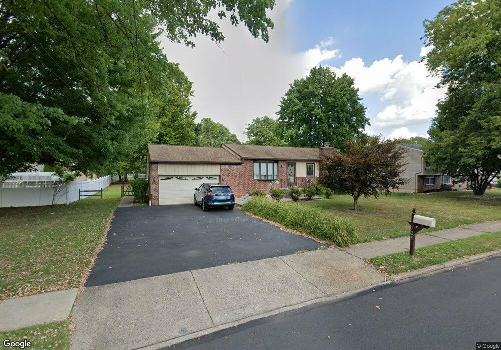
725 Claire Rd Warminster, PA 18974
Estimated Value: $427,000 - $443,171
--
Bed
1
Bath
1,200
Sq Ft
$365/Sq Ft
Est. Value
About This Home
This home is located at 725 Claire Rd, Warminster, PA 18974 and is currently estimated at $437,543, approximately $364 per square foot. 725 Claire Rd is a home located in Bucks County with nearby schools including Willow Dale El School, Log College Middle School, and William Tennent High School.
Ownership History
Date
Name
Owned For
Owner Type
Purchase Details
Closed on
Mar 16, 2023
Sold by
Dehart Charles and Dehart Eleanor
Bought by
Dehart Charles and Dehart Michael J
Current Estimated Value
Purchase Details
Closed on
Feb 28, 2008
Sold by
Gordon Joseph and Gordon Joseph A
Bought by
Dehart Charles and Dehart Eleanor
Home Financials for this Owner
Home Financials are based on the most recent Mortgage that was taken out on this home.
Original Mortgage
$50,000
Interest Rate
5.57%
Mortgage Type
Purchase Money Mortgage
Purchase Details
Closed on
Dec 19, 2006
Sold by
Gregg James D and Gregg June V
Bought by
Gordon Joseph
Home Financials for this Owner
Home Financials are based on the most recent Mortgage that was taken out on this home.
Original Mortgage
$200,000
Interest Rate
6.24%
Mortgage Type
Purchase Money Mortgage
Purchase Details
Closed on
Jun 26, 1996
Sold by
Schell Clyde H and Schell Arlene B
Bought by
Schell Arlene B
Create a Home Valuation Report for This Property
The Home Valuation Report is an in-depth analysis detailing your home's value as well as a comparison with similar homes in the area
Home Values in the Area
Average Home Value in this Area
Purchase History
| Date | Buyer | Sale Price | Title Company |
|---|---|---|---|
| Dehart Charles | -- | None Listed On Document | |
| Dehart Charles | $289,000 | None Available | |
| Gordon Joseph | $284,000 | None Available | |
| Schell Arlene B | -- | -- |
Source: Public Records
Mortgage History
| Date | Status | Borrower | Loan Amount |
|---|---|---|---|
| Previous Owner | Dehart Charles | $50,000 | |
| Previous Owner | Gordon Joseph | $200,000 |
Source: Public Records
Tax History Compared to Growth
Tax History
| Year | Tax Paid | Tax Assessment Tax Assessment Total Assessment is a certain percentage of the fair market value that is determined by local assessors to be the total taxable value of land and additions on the property. | Land | Improvement |
|---|---|---|---|---|
| 2025 | $4,728 | $22,400 | $5,440 | $16,960 |
| 2024 | $4,728 | $22,400 | $5,440 | $16,960 |
| 2023 | $4,582 | $22,400 | $5,440 | $16,960 |
| 2022 | $4,484 | $22,400 | $5,440 | $16,960 |
| 2021 | $4,380 | $22,400 | $5,440 | $16,960 |
| 2020 | $4,318 | $22,400 | $5,440 | $16,960 |
| 2019 | $4,089 | $22,400 | $5,440 | $16,960 |
| 2018 | $3,991 | $22,400 | $5,440 | $16,960 |
| 2017 | $3,874 | $22,400 | $5,440 | $16,960 |
| 2016 | $3,874 | $22,400 | $5,440 | $16,960 |
| 2015 | $3,824 | $22,400 | $5,440 | $16,960 |
| 2014 | $3,824 | $22,400 | $5,440 | $16,960 |
Source: Public Records
Map
Nearby Homes
- 735 Claire Rd
- 898 Walnut Rd
- 724 Cypress Rd
- 163 W County Line Rd
- 491 Prospect Rd
- 425 Grape St
- 586A Olive St
- 1002 Windsor Rd
- 0 York Rd
- 990 Meadow Glen Rd
- 446 Maple St
- 315 Fir St
- 13 Belmar Rd
- 416 Aspen Ln
- 1130 Victoria Rd
- 236 Oak Hill Dr
- 122 Yorkshire Way Unit D
- 713 Mason Dr
- L:26 Street Rd
- 632 Longfellow Ct