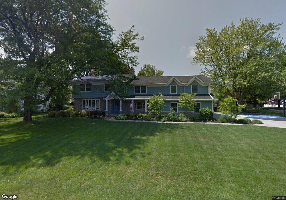
725 Clifton Blvd Mansfield, OH 44907
Estimated Value: $311,937 - $441,000
8
Beds
4
Baths
3,271
Sq Ft
$107/Sq Ft
Est. Value
About This Home
This home is located at 725 Clifton Blvd, Mansfield, OH 44907 and is currently estimated at $350,484, approximately $107 per square foot. 725 Clifton Blvd is a home located in Richland County with nearby schools including Mansfield Christian School, Discovery School, and Mansfield Seventh-day Adventist School.
Ownership History
Date
Name
Owned For
Owner Type
Purchase Details
Closed on
Dec 16, 2014
Sold by
Maxwell Robert J and Maxwell Jennifer A
Bought by
Maxwell Jennifer A
Current Estimated Value
Purchase Details
Closed on
Jul 3, 1995
Sold by
Marikis Dennis A
Bought by
Maxwell Robert J and Maxwell Jennifer A
Home Financials for this Owner
Home Financials are based on the most recent Mortgage that was taken out on this home.
Original Mortgage
$127,600
Interest Rate
5.95%
Mortgage Type
New Conventional
Create a Home Valuation Report for This Property
The Home Valuation Report is an in-depth analysis detailing your home's value as well as a comparison with similar homes in the area
Home Values in the Area
Average Home Value in this Area
Purchase History
| Date | Buyer | Sale Price | Title Company |
|---|---|---|---|
| Maxwell Jennifer A | -- | Attorney | |
| Maxwell Robert J | $159,500 | -- |
Source: Public Records
Mortgage History
| Date | Status | Borrower | Loan Amount |
|---|---|---|---|
| Closed | Maxwell Robert J | $127,600 |
Source: Public Records
Tax History Compared to Growth
Tax History
| Year | Tax Paid | Tax Assessment Tax Assessment Total Assessment is a certain percentage of the fair market value that is determined by local assessors to be the total taxable value of land and additions on the property. | Land | Improvement |
|---|---|---|---|---|
| 2024 | $3,768 | $80,480 | $12,970 | $67,510 |
| 2023 | $3,768 | $80,480 | $12,970 | $67,510 |
| 2022 | $3,326 | $59,520 | $10,820 | $48,700 |
| 2021 | $3,349 | $59,520 | $10,820 | $48,700 |
| 2020 | $3,424 | $59,520 | $10,820 | $48,700 |
| 2019 | $3,795 | $59,520 | $10,820 | $48,700 |
| 2018 | $3,743 | $59,520 | $10,820 | $48,700 |
| 2017 | $3,765 | $59,520 | $10,820 | $48,700 |
| 2016 | $3,887 | $61,590 | $10,490 | $51,100 |
| 2015 | $3,887 | $61,590 | $10,490 | $51,100 |
| 2014 | $3,664 | $61,590 | $10,490 | $51,100 |
| 2012 | $1,439 | $63,500 | $10,820 | $52,680 |
Source: Public Records
Map
Nearby Homes
- 654 Courtwright Blvd
- 1163 Woodland Rd
- 1009 Woodhill Rd
- 0 U S Highway 42
- 589 Andover Rd
- 501 Clifton Blvd
- 240 Whippoorwill Ln Unit 240
- 476 Glendale Blvd
- 1156 Briarwood Rd
- 0 George Ave
- 655 Woodhill Rd
- 1201 W Cook Rd
- 646 Kennedy Dr
- 421 Edgewood Rd
- 0 Bally Row Unit Lot 22940 223011208
- 0 Bally Row Unit Lot 22930 223011207
- 0 Bally Row Unit Lot 22929 223011206
- 0 S Trimble Rd
- 0 Lexington Ave Unit 224009661
- 431 Overlook Rd
- 715 Clifton Blvd
- 755 Clifton Blvd
- 724 Courtwright Blvd
- 744 Courtwright Blvd
- 716 Clifton Blvd
- 712 Courtwright Blvd
- 756 Courtwright Blvd
- 705 Clifton Blvd
- 781 Clifton Blvd
- 724 Clifton Blvd
- 700 Clifton Blvd
- 700 Courtwright Blvd
- 789 Clifton Blvd
- 764 Courtwright Blvd
- 717 Westview Blvd
- 743 Courtwright Blvd
- 735 Courtwright Blvd
- 1052 Woodland Rd
- 746 Clifton Blvd
- 1060 Woodland Rd