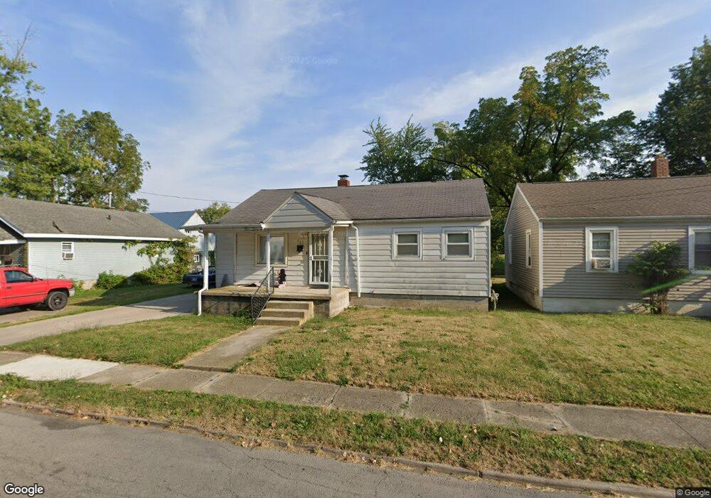
725 Michael Ave Lima, OH 45804
Fifth Ward NeighborhoodEstimated Value: $42,000 - $97,000
2
Beds
1
Bath
1,176
Sq Ft
$57/Sq Ft
Est. Value
About This Home
This home is located at 725 Michael Ave, Lima, OH 45804 and is currently estimated at $66,796, approximately $56 per square foot. 725 Michael Ave is a home located in Allen County with nearby schools including Freedom Elementary School, Lima North Middle School, and Lima West Middle School.
Ownership History
Date
Name
Owned For
Owner Type
Purchase Details
Closed on
Sep 12, 2019
Sold by
James Elizabeth A
Bought by
Thompson Ebony and Manley Troy
Current Estimated Value
Purchase Details
Closed on
May 8, 2008
Sold by
Jennings Orville J and Jennings Debra A
Bought by
James Elizabeth A
Home Financials for this Owner
Home Financials are based on the most recent Mortgage that was taken out on this home.
Original Mortgage
$22,000
Interest Rate
5.88%
Mortgage Type
Purchase Money Mortgage
Purchase Details
Closed on
Jul 1, 1982
Bought by
Jennings Orville J
Create a Home Valuation Report for This Property
The Home Valuation Report is an in-depth analysis detailing your home's value as well as a comparison with similar homes in the area
Home Values in the Area
Average Home Value in this Area
Purchase History
| Date | Buyer | Sale Price | Title Company |
|---|---|---|---|
| Thompson Ebony | $14,000 | None Available | |
| James Elizabeth A | $22,000 | Attorney | |
| Jennings Orville J | $25,000 | -- |
Source: Public Records
Mortgage History
| Date | Status | Borrower | Loan Amount |
|---|---|---|---|
| Previous Owner | James Elizabeth A | $22,000 |
Source: Public Records
Tax History
| Year | Tax Paid | Tax Assessment Tax Assessment Total Assessment is a certain percentage of the fair market value that is determined by local assessors to be the total taxable value of land and additions on the property. | Land | Improvement |
|---|---|---|---|---|
| 2024 | $358 | $8,300 | $2,000 | $6,300 |
| 2023 | $383 | $7,880 | $1,890 | $5,990 |
| 2022 | $383 | $7,880 | $1,890 | $5,990 |
| 2021 | $446 | $7,880 | $1,890 | $5,990 |
| 2020 | $431 | $7,560 | $1,890 | $5,670 |
| 2019 | $431 | $7,560 | $1,890 | $5,670 |
| 2018 | $427 | $7,560 | $1,890 | $5,670 |
| 2017 | $432 | $7,560 | $1,890 | $5,670 |
| 2016 | $439 | $7,560 | $1,890 | $5,670 |
| 2015 | $479 | $7,560 | $1,890 | $5,670 |
| 2014 | $479 | $8,270 | $2,000 | $6,270 |
| 2013 | $467 | $8,270 | $2,000 | $6,270 |
Source: Public Records
Map
Nearby Homes
- 727 Michael Ave
- 711 Michael Ave
- 731 Michael Ave
- 726 Michael Ave
- 1019 S Scott St
- 705 Michael Ave
- 735 Michael Ave
- 1015 S Scott St
- 724 Michael Ave
- 722 Michael Ave
- 716 Michael Ave
- 732 Michael Ave
- 720 Michael Ave
- 734 Michael Ave
- 716 E Vine St
- 1118 Harrison Ave
- 745 Michael Ave
- 623 Michael Ave
- 730 E Vine St
Your Personal Tour Guide
Ask me questions while you tour the home.