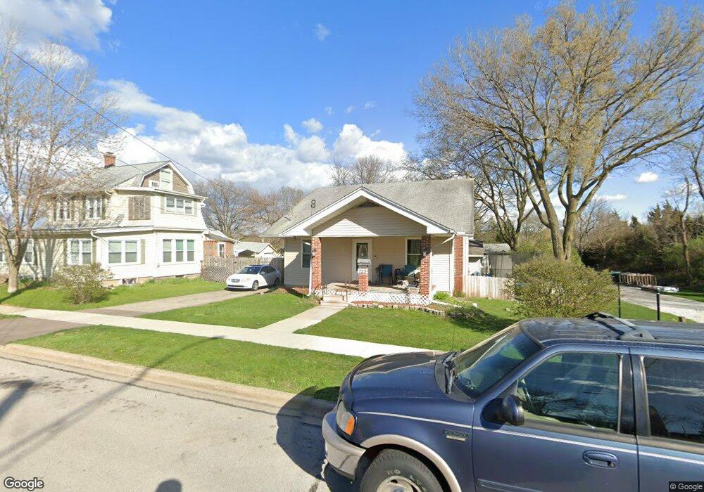
725 S River St Montgomery, IL 60538
South Montgomery NeighborhoodEstimated Value: $252,000 - $297,000
3
Beds
1
Bath
1,462
Sq Ft
$183/Sq Ft
Est. Value
About This Home
This home is located at 725 S River St, Montgomery, IL 60538 and is currently estimated at $268,161, approximately $183 per square foot. 725 S River St is a home located in Kendall County with nearby schools including Boulder Hill Elementary School, Thompson Jr. High School, and Oswego High School.
Ownership History
Date
Name
Owned For
Owner Type
Purchase Details
Closed on
Nov 29, 2006
Sold by
Lavigne Jana L and Lavigne David
Bought by
Forbes James J and Forbes Christina L
Current Estimated Value
Home Financials for this Owner
Home Financials are based on the most recent Mortgage that was taken out on this home.
Original Mortgage
$162,400
Outstanding Balance
$97,364
Interest Rate
6.36%
Mortgage Type
New Conventional
Estimated Equity
$170,797
Purchase Details
Closed on
Apr 13, 2002
Sold by
Riis Shawn M
Bought by
Riis Jana L
Purchase Details
Closed on
Sep 25, 1998
Sold by
Backes Gary D and Backes James J
Bought by
Riis Jana L and Riis Shawn M
Home Financials for this Owner
Home Financials are based on the most recent Mortgage that was taken out on this home.
Original Mortgage
$77,000
Interest Rate
6.99%
Create a Home Valuation Report for This Property
The Home Valuation Report is an in-depth analysis detailing your home's value as well as a comparison with similar homes in the area
Home Values in the Area
Average Home Value in this Area
Purchase History
| Date | Buyer | Sale Price | Title Company |
|---|---|---|---|
| Forbes James J | $169,000 | Chicago Title Insurance Co | |
| Riis Jana L | -- | -- | |
| Riis Jana L | $92,000 | -- |
Source: Public Records
Mortgage History
| Date | Status | Borrower | Loan Amount |
|---|---|---|---|
| Open | Forbes James J | $162,400 | |
| Previous Owner | Riis Jana L | $77,000 |
Source: Public Records
Tax History Compared to Growth
Tax History
| Year | Tax Paid | Tax Assessment Tax Assessment Total Assessment is a certain percentage of the fair market value that is determined by local assessors to be the total taxable value of land and additions on the property. | Land | Improvement |
|---|---|---|---|---|
| 2024 | $4,894 | $66,008 | $12,418 | $53,590 |
| 2023 | $4,411 | $57,398 | $10,798 | $46,600 |
| 2022 | $4,411 | $53,643 | $10,092 | $43,551 |
| 2021 | $4,479 | $52,591 | $9,894 | $42,697 |
| 2020 | $4,536 | $52,591 | $9,894 | $42,697 |
| 2019 | $4,619 | $52,591 | $9,894 | $42,697 |
| 2018 | $4,741 | $52,298 | $9,839 | $42,459 |
| 2017 | $4,703 | $50,287 | $9,461 | $40,826 |
| 2016 | $4,506 | $47,666 | $8,968 | $38,698 |
| 2015 | $4,386 | $44,547 | $8,381 | $36,166 |
| 2014 | -- | $42,834 | $8,059 | $34,775 |
| 2013 | -- | $43,266 | $8,140 | $35,126 |
Source: Public Records
Map
Nearby Homes
- 125 S Main St
- 17 Knollwood Dr Unit 3
- 1 Highway 30
- 75 Briarcliff Rd
- 29 Briarcliff Rd
- 133 Autumn Rdg Dr
- 170 Montgomery Rd
- 117 Boulder Hill Pass Unit 117
- 34 Pembrooke Rd
- 19 Wyndham Dr Unit 10
- 3 Scarsdale Rd
- 1342 Oak Ridge Ln
- 1707 Deer Run Dr
- 15 Crescent Ct
- 1375 Manning Ave
- 1417 Manning Ave
- 54 Sierra Rd
- 1405 Manning Ave
- 1422 Manning Ave
- 8 Clay Ct