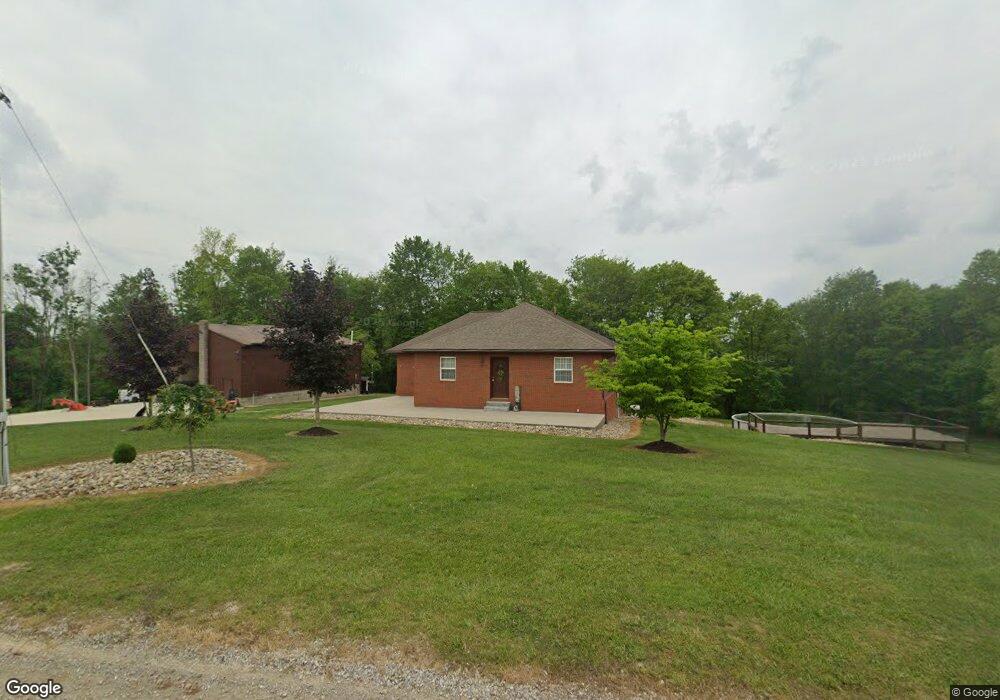
72515 Grapevine Rd Freeport, OH 43973
Estimated Value: $342,000 - $487,000
3
Beds
2
Baths
1,863
Sq Ft
$220/Sq Ft
Est. Value
About This Home
This home is located at 72515 Grapevine Rd, Freeport, OH 43973 and is currently estimated at $409,421, approximately $219 per square foot. 72515 Grapevine Rd is a home located in Guernsey County with nearby schools including Buckeye Trail Elementary School, Buckeye Trail Middle School, and Buckeye Trail High School.
Ownership History
Date
Name
Owned For
Owner Type
Purchase Details
Closed on
Mar 30, 2018
Sold by
Kimble James S and Kimble Sarah D
Bought by
Carpenter Amy Nicole and Carpenter Keith Austin
Current Estimated Value
Home Financials for this Owner
Home Financials are based on the most recent Mortgage that was taken out on this home.
Original Mortgage
$234,650
Outstanding Balance
$201,748
Interest Rate
4.43%
Mortgage Type
New Conventional
Estimated Equity
$207,673
Purchase Details
Closed on
Jun 6, 2014
Sold by
Kimble James S and Kimble Sarah D
Bought by
Wright Paul C and Wright Susan E
Create a Home Valuation Report for This Property
The Home Valuation Report is an in-depth analysis detailing your home's value as well as a comparison with similar homes in the area
Home Values in the Area
Average Home Value in this Area
Purchase History
| Date | Buyer | Sale Price | Title Company |
|---|---|---|---|
| Carpenter Amy Nicole | $247,000 | Seo Title Agency | |
| Wright Paul C | $70,000 | Bennett Title Agency |
Source: Public Records
Mortgage History
| Date | Status | Borrower | Loan Amount |
|---|---|---|---|
| Open | Carpenter Amy Nicole | $234,650 |
Source: Public Records
Tax History Compared to Growth
Tax History
| Year | Tax Paid | Tax Assessment Tax Assessment Total Assessment is a certain percentage of the fair market value that is determined by local assessors to be the total taxable value of land and additions on the property. | Land | Improvement |
|---|---|---|---|---|
| 2024 | $3,695 | $97,075 | $31,566 | $65,509 |
| 2023 | $3,695 | $85,158 | $27,692 | $57,466 |
| 2022 | $3,425 | $85,150 | $27,690 | $57,460 |
| 2021 | $3,299 | $85,150 | $27,690 | $57,460 |
| 2020 | $3,145 | $81,960 | $18,730 | $63,230 |
| 2019 | $3,115 | $81,960 | $18,730 | $63,230 |
| 2018 | $3,051 | $81,960 | $18,730 | $63,230 |
| 2017 | $2,866 | $71,070 | $16,290 | $54,780 |
| 2016 | $2,843 | $71,070 | $16,290 | $54,780 |
| 2015 | $2,850 | $71,070 | $16,290 | $54,780 |
| 2014 | -- | $62,430 | $11,790 | $50,640 |
| 2013 | $8,486 | $62,430 | $11,790 | $50,640 |
Source: Public Records
Map
Nearby Homes
- 16965 Anderson Rd
- 0 Masada Ln Unit LotWP001
- 0 Masada Ln
- 19819 Cadiz Rd
- 73353 Birmingham Rd
- 70791 Birmingham Rd N
- 18063 Sligo Rd
- 18513 Hobbler Ln
- 16182 Gunn Rd
- 73117 Deck Rd
- 69375 Birmingham Rd N
- 18010 Winterset Ln
- 14620 Freedom Rd
- 21639 Baptist Rd
- 78501 Anderson Rd
- 0 Anderson Rd Unit 5159508
- 73710 Repik Ln
- 5991 Sandy Ridge Rd SE
- 338 High St
- 73291 Seminary Rd