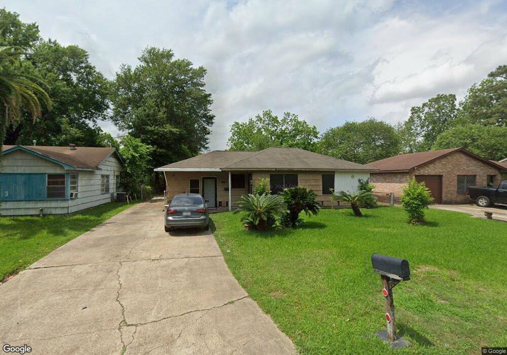
7257 Wiley Rd Houston, TX 77016
East Little York NeighborhoodEstimated Value: $156,843 - $174,000
3
Beds
1
Bath
1,240
Sq Ft
$135/Sq Ft
Est. Value
About This Home
This home is located at 7257 Wiley Rd, Houston, TX 77016 and is currently estimated at $167,461, approximately $135 per square foot. 7257 Wiley Rd is a home located in Harris County with nearby schools including Shadydale Elementary School, Forest Brook Middle, and North Forest High School.
Ownership History
Date
Name
Owned For
Owner Type
Purchase Details
Closed on
Sep 14, 2022
Sold by
Valarie Marshall-Hopkins
Bought by
Marshall-Hopkins Valarie
Current Estimated Value
Purchase Details
Closed on
May 16, 2021
Sold by
Hopkins Valarie Marshall
Bought by
Hopkins Tyler M
Purchase Details
Closed on
Apr 20, 2021
Sold by
Chase Elma
Bought by
Hopkins Tyler
Purchase Details
Closed on
Apr 30, 2003
Sold by
White James L
Bought by
Marshall Hopkins Valarie M
Home Financials for this Owner
Home Financials are based on the most recent Mortgage that was taken out on this home.
Original Mortgage
$60,000
Interest Rate
5.8%
Mortgage Type
VA
Purchase Details
Closed on
Sep 4, 2001
Sold by
Smith Ora L
Bought by
White James L
Create a Home Valuation Report for This Property
The Home Valuation Report is an in-depth analysis detailing your home's value as well as a comparison with similar homes in the area
Home Values in the Area
Average Home Value in this Area
Purchase History
| Date | Buyer | Sale Price | Title Company |
|---|---|---|---|
| Marshall-Hopkins Valarie | -- | -- | |
| Hopkins Tyler M | -- | None Listed On Document | |
| Hopkins Tyler | -- | None Available | |
| Marshall Hopkins Valarie M | -- | -- | |
| White James L | -- | -- |
Source: Public Records
Mortgage History
| Date | Status | Borrower | Loan Amount |
|---|---|---|---|
| Previous Owner | Marshall Hopkins Valarie M | $60,000 |
Source: Public Records
Tax History Compared to Growth
Tax History
| Year | Tax Paid | Tax Assessment Tax Assessment Total Assessment is a certain percentage of the fair market value that is determined by local assessors to be the total taxable value of land and additions on the property. | Land | Improvement |
|---|---|---|---|---|
| 2025 | $1,198 | $124,953 | $52,287 | $72,666 |
| 2024 | $1,198 | $121,996 | $52,287 | $69,709 |
| 2023 | $1,198 | $127,229 | $43,272 | $83,957 |
| 2022 | $2,291 | $104,042 | $36,060 | $67,982 |
| 2021 | $1,377 | $90,691 | $27,045 | $63,646 |
| 2020 | $1,300 | $79,964 | $18,751 | $61,213 |
| 2019 | $1,235 | $73,417 | $12,333 | $61,084 |
| 2018 | $601 | $59,627 | $12,333 | $47,294 |
| 2017 | $1,020 | $59,627 | $12,333 | $47,294 |
| 2016 | $928 | $59,627 | $12,333 | $47,294 |
| 2015 | $445 | $38,978 | $12,333 | $26,645 |
| 2014 | $445 | $33,342 | $12,333 | $21,009 |
Source: Public Records
Map
Nearby Homes
- 7234 Boggess Rd
- 7210 Colton St
- 7226 Gore Dr
- 7306 Parker Rd
- 7252 Parker Rd
- 10317 Kelburn Dr
- 7305 Yoe St
- 10128 Homestead Rd
- 10124 Homestead Rd
- 10120 Homestead Rd
- 7220 Parker Rd
- 10313 Blades St
- 10201 Homestead Rd
- 10806 Bird of Paradise Ln
- 10808 Bird of Paradise Ln
- 10810 Bird of Paradise Ln
- 7818 Laurel Gem Dr
- 7827 Laurel Gem Dr
- 7823 Laurel Gem Dr
- 7821 Laurel Gem Dr