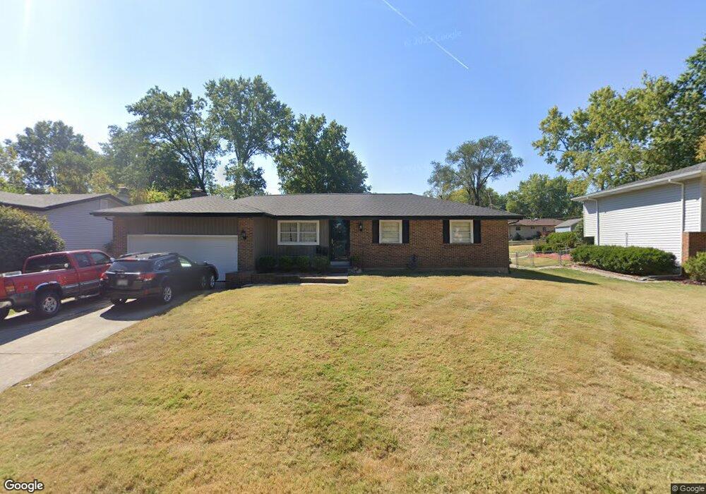
726 Montbrook Dr O Fallon, MO 63366
Estimated Value: $283,969 - $311,000
3
Beds
2
Baths
1,458
Sq Ft
$206/Sq Ft
Est. Value
About This Home
This home is located at 726 Montbrook Dr, O Fallon, MO 63366 and is currently estimated at $299,742, approximately $205 per square foot. 726 Montbrook Dr is a home located in St. Charles County with nearby schools including Joseph L. Mudd Elementary School, Forest Park Elementary School, and Fort Zumwalt North Middle School.
Ownership History
Date
Name
Owned For
Owner Type
Purchase Details
Closed on
Nov 24, 2004
Sold by
Culver Robert E and Culver Brenda M
Bought by
Culver Brenda M
Current Estimated Value
Home Financials for this Owner
Home Financials are based on the most recent Mortgage that was taken out on this home.
Original Mortgage
$116,000
Outstanding Balance
$54,269
Interest Rate
4.75%
Mortgage Type
New Conventional
Estimated Equity
$245,473
Purchase Details
Closed on
Mar 15, 2002
Sold by
Radcliff Claude and Radcliff Margaret T
Bought by
Culver Robert E and Culver Brenda M
Home Financials for this Owner
Home Financials are based on the most recent Mortgage that was taken out on this home.
Original Mortgage
$127,046
Interest Rate
6.83%
Mortgage Type
FHA
Create a Home Valuation Report for This Property
The Home Valuation Report is an in-depth analysis detailing your home's value as well as a comparison with similar homes in the area
Home Values in the Area
Average Home Value in this Area
Purchase History
| Date | Buyer | Sale Price | Title Company |
|---|---|---|---|
| Culver Brenda M | -- | Ust | |
| Culver Robert E | -- | -- |
Source: Public Records
Mortgage History
| Date | Status | Borrower | Loan Amount |
|---|---|---|---|
| Open | Culver Brenda M | $116,000 | |
| Closed | Culver Robert E | $127,046 | |
| Closed | Culver Brenda M | $21,750 |
Source: Public Records
Tax History
| Year | Tax Paid | Tax Assessment Tax Assessment Total Assessment is a certain percentage of the fair market value that is determined by local assessors to be the total taxable value of land and additions on the property. | Land | Improvement |
|---|---|---|---|---|
| 2025 | $2,902 | $46,902 | -- | -- |
| 2023 | $2,904 | $43,711 | -- | -- |
| 2022 | $2,552 | $35,693 | $0 | $0 |
| 2021 | $2,554 | $35,693 | $0 | $0 |
| 2020 | $2,406 | $32,609 | $0 | $0 |
| 2019 | $2,412 | $32,609 | $0 | $0 |
| 2018 | $2,266 | $29,241 | $0 | $0 |
| 2017 | $2,231 | $29,241 | $0 | $0 |
| 2016 | $1,920 | $25,050 | $0 | $0 |
| 2015 | $1,785 | $25,050 | $0 | $0 |
| 2014 | $1,741 | $24,035 | $0 | $0 |
Source: Public Records
Map
Nearby Homes
- 0 Montbrook Dr
- 302 Birmingham Dr
- 7 Autumn Valley Ct
- 151 N Wellington St
- 11 Southern Hills Ct
- 10 Southern Hills Ct
- 24 Hawthorne Ct
- 205 E Elm St
- 309 E Pitman St
- 713 Plaza Dr
- 512 Sonderen St
- 866 Sherwood Forest Ct
- 319 Magnolia Valley Dr
- 849 Elaine Dr
- 1117 Turtle Creek Dr
- 6 Emerson Ct
- 3 Pinehurst Forest Ct
- 710 Longfellow Cir
- 532 Bramblett Hills
- 203 Saint Margaret Ln
- 722 Montbrook Dr
- 730 Montbrook Dr
- 718 Montbrook Dr
- 732 Montbrook Dr
- 727 Cordes St
- 735 Cordes St
- 716 Montbrook Dr
- 723 Cordes St
- 727 Montbrook Dr
- 736 Montbrook Dr
- 733 Montbrook Dr
- 725 Montbrook Dr
- 735 Montbrook Dr
- 739 Cordes St
- 714 Montbrook Dr
- 719 Montbrook Dr
- 719 Cordes St
- 740 Montbrook Dr
- 737 Montbrook Dr
- 740R Montbrook
Your Personal Tour Guide
Ask me questions while you tour the home.