Estimated Value: $271,430 - $278,000
3
Beds
2
Baths
1,344
Sq Ft
$205/Sq Ft
Est. Value
About This Home
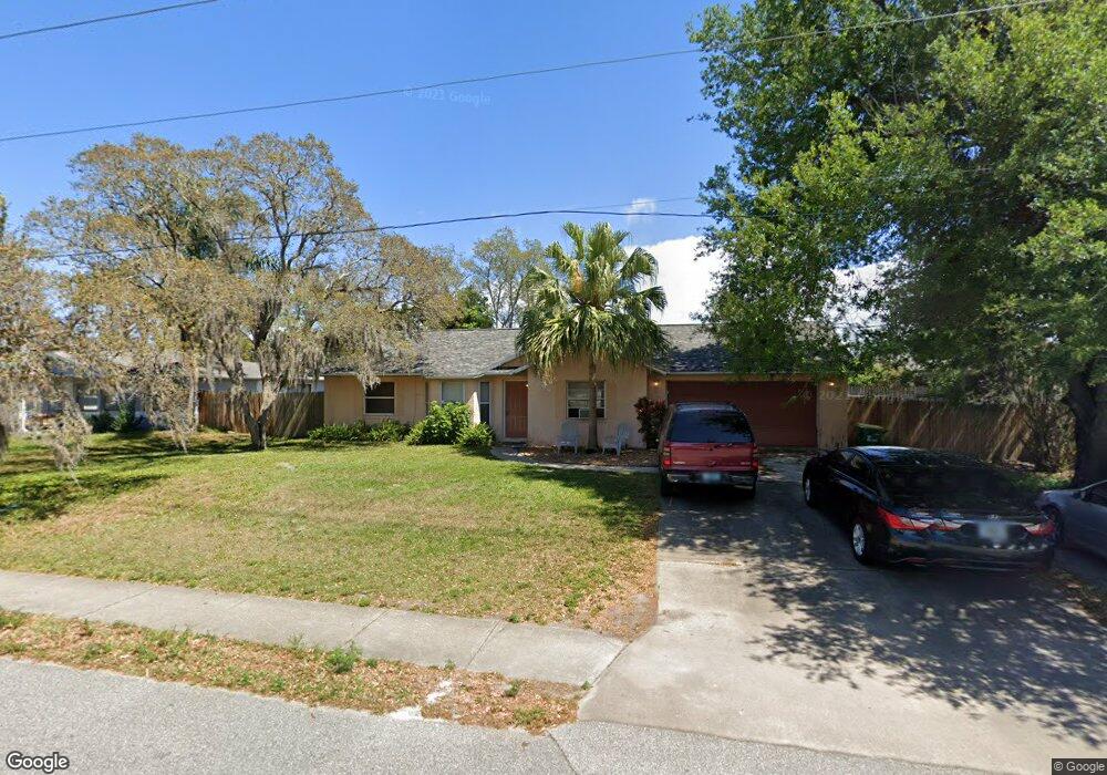
This home is located at 7265 Briggs Ave, Cocoa, FL 32927 and is currently estimated at $275,858, approximately $205 per square foot. 7265 Briggs Ave is a home located in Brevard County with nearby schools including Atlantis Elementary School, Space Coast Junior/Senior High School, and Sculptor Charter School.
Ownership History
Date
Name
Owned For
Owner Type
Purchase Details
Closed on
May 8, 2012
Sold by
Noriega Damien C and Noriega Debra
Bought by
Federal National Mortgage Association
Current Estimated Value
Purchase Details
Closed on
Mar 19, 2004
Sold by
Cadore Anthony V and Cadore Dawn L
Bought by
Vasquez Jose W and Vasquez Doris
Home Financials for this Owner
Home Financials are based on the most recent Mortgage that was taken out on this home.
Original Mortgage
$111,600
Interest Rate
5.53%
Create a Home Valuation Report for This Property
The Home Valuation Report is an in-depth analysis detailing your home's value as well as a comparison with similar homes in the area
Home Values in the Area
Average Home Value in this Area
Purchase History
We collect this data history from publicly available records. To have your information removed, we recommend requesting removal directly through your county’s website.
| Date | Buyer | Sale Price | Title Company |
|---|---|---|---|
| Federal National Mortgage Association | $43,000 | Attorney | |
| Vasquez Jose W | $124,000 | Fidelity National Title Insu |
Source: Public Records
Mortgage History
We collect this data history from publicly available records. To have your information removed, we recommend requesting removal directly through your county’s website.
| Date | Status | Borrower | Loan Amount |
|---|---|---|---|
| Previous Owner | Vasquez Jose W | $111,600 |
Source: Public Records
Tax History
| Year | Tax Paid | Tax Assessment Tax Assessment Total Assessment is a certain percentage of the fair market value that is determined by local assessors to be the total taxable value of land and additions on the property. | Land | Improvement |
|---|---|---|---|---|
| 2025 | $3,128 | $222,770 | -- | -- |
| 2024 | $3,044 | $227,240 | -- | -- |
| 2023 | $3,044 | $223,470 | $0 | $0 |
| 2022 | $2,754 | $213,850 | $0 | $0 |
| 2021 | $2,495 | $161,540 | $42,000 | $119,540 |
| 2020 | $2,298 | $144,780 | $40,000 | $104,780 |
| 2019 | $2,179 | $139,950 | $35,000 | $104,950 |
| 2018 | $2,069 | $127,970 | $27,000 | $100,970 |
| 2017 | $1,955 | $113,000 | $24,000 | $89,000 |
| 2016 | $1,832 | $96,710 | $18,000 | $78,710 |
| 2015 | $1,744 | $76,910 | $15,000 | $61,910 |
| 2014 | $1,596 | $69,920 | $11,000 | $58,920 |
Source: Public Records
Map
Nearby Homes
- 7250 Carlowe Ave
- 4515 Flood St
- 7210 Barbara Rd
- 7065 Bright Ave
- 4575 Curtis Blvd
- 7350 Bartow Ave
- 4625 Curtis Blvd
- 7081 Bayfront Rd
- 7456 Camio Ave
- 4765 Curtis Blvd
- 7455 Darien Rd
- 4821 Falcon Blvd
- 00 Kings Hwy
- 0 Cinnamon Fern Blvd
- 4770 Ivan St
- 6800 Ackerman Ave
- 4824 Curtis Blvd
- 5145 Everett St
- 0 Kanawha St
- 858 Kanawha St
- 7260 Carlowe Ave
- 7240 Carlowe Ave
- 7255 Briggs Ave
- 7270 Carlowe Ave
- 7230 Carlowe Ave
- 7257 Carlowe Ave
- 7265 Carlowe Ave
- 7275 Briggs Ave
- 7241 Carlowe Ave
- 7235 Briggs Ave
- 7273 Carlowe Ave
- 7220 Carlowe Ave
- 4465 Feather St
- 7285 Briggs Ave
- 7225 Briggs Ave
- 7256 Bright Ave
- 4445 Feather St
- 7225 Carlowe Ave
- 7268 Bright Ave
- 7244 Bright Ave
Your Personal Tour Guide
Ask me questions while you tour the home.