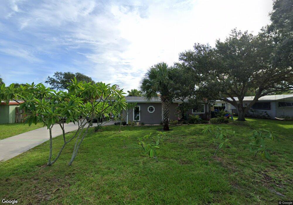
727 Nassau Rd Cocoa Beach, FL 32931
Estimated Value: $561,947 - $695,000
3
Beds
2
Baths
1,938
Sq Ft
$336/Sq Ft
Est. Value
About This Home
This home is located at 727 Nassau Rd, Cocoa Beach, FL 32931 and is currently estimated at $651,987, approximately $336 per square foot. 727 Nassau Rd is a home located in Brevard County with nearby schools including Theodore Roosevelt Elementary School, Cocoa Beach Junior/Senior High School, and Cocoa Beach Christian School.
Ownership History
Date
Name
Owned For
Owner Type
Purchase Details
Closed on
Jun 20, 2022
Sold by
Rizzo James M and Rizzo Lorraine C
Bought by
Rizzo James M
Current Estimated Value
Purchase Details
Closed on
Jun 27, 1997
Sold by
Dygert Edward L
Bought by
Rizzo James M and Rizzo Lorraine C
Purchase Details
Closed on
Sep 20, 1995
Sold by
Rizzo James M and Rizzo Lorraine C
Bought by
Dygert Edward L
Home Financials for this Owner
Home Financials are based on the most recent Mortgage that was taken out on this home.
Original Mortgage
$79,081
Interest Rate
7.74%
Purchase Details
Closed on
Apr 7, 1994
Sold by
Rizzo James M and Rizzo Lorraine C
Bought by
Rizzo James M and Rizz Lorraine C
Create a Home Valuation Report for This Property
The Home Valuation Report is an in-depth analysis detailing your home's value as well as a comparison with similar homes in the area
Home Values in the Area
Average Home Value in this Area
Purchase History
| Date | Buyer | Sale Price | Title Company |
|---|---|---|---|
| Rizzo James M | -- | William A Johnson Pa | |
| Rizzo James M | $2,000 | -- | |
| Dygert Edward L | $99,900 | -- | |
| Rizzo James M | $6,000 | -- |
Source: Public Records
Mortgage History
| Date | Status | Borrower | Loan Amount |
|---|---|---|---|
| Previous Owner | Dygert Edward L | $79,081 |
Source: Public Records
Tax History Compared to Growth
Tax History
| Year | Tax Paid | Tax Assessment Tax Assessment Total Assessment is a certain percentage of the fair market value that is determined by local assessors to be the total taxable value of land and additions on the property. | Land | Improvement |
|---|---|---|---|---|
| 2025 | $2,042 | $167,230 | -- | -- |
| 2024 | $1,989 | $162,520 | -- | -- |
| 2023 | $1,989 | $157,790 | $0 | $0 |
| 2022 | $1,827 | $153,200 | $0 | $0 |
| 2021 | $1,813 | $148,740 | $0 | $0 |
| 2020 | $1,795 | $146,690 | $0 | $0 |
| 2019 | $1,776 | $143,400 | $0 | $0 |
| 2018 | $1,763 | $140,730 | $0 | $0 |
| 2017 | $1,768 | $137,840 | $0 | $0 |
| 2016 | $1,758 | $135,010 | $110,000 | $25,010 |
| 2015 | $1,757 | $134,080 | $100,000 | $34,080 |
| 2014 | $1,760 | $133,020 | $81,000 | $52,020 |
Source: Public Records
Map
Nearby Homes
- 737 Nassau Rd
- 787 Nassau Rd
- 663 Bermuda Rd
- 936 Santa Cruz Rd
- 276 Curacau Dr
- 249 Curacau Dr
- 1214 Samar Rd
- 714 Catalina Rd Unit 15
- 714 Catalina Rd Unit 2
- 500 Catalina Rd Unit 203
- 308 Formosa Dr
- 830 N Atlantic Ave Unit B1703
- 830 N Atlantic Ave Unit B502
- 830 N Atlantic Ave Unit B908
- 830 N Atlantic Ave Unit B1406
- 830 N Atlantic Ave Unit B1002
- 830 N Atlantic Ave Unit B903
- 0 Unknown Unit 1061043
- 416 N 4th St
- 492 Dempsey Dr