NOT LISTED FOR SALE

7279 Fisher Rd Ontario, NY 14519

Estimated Value: $135,925 - $155,000

28 Acres
$5,118 Price per Acre
1,219,680 Sq Ft Lot

Last Sold April 06, 2016

Last sale price $77,500

Est. 85% increase in value since last sale

Current estimated payment $788/month

167 Days on Market

Highlights

  • 28 Acre Lot
  • Partially Wooded Lot
  • Lot Has A Rolling Slope

About This Lot

As of April 2016

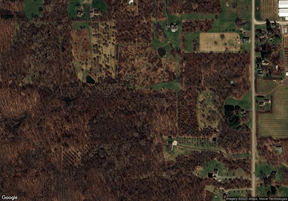
Great property for your home or for recreational use. Approx. 28 acres plus or minus. Must be subdivided from larger parcel. Taxes and assessment to be determined.

Last Agent to Sell the Property

Bob Carr

Listing by Dixon & Carr Realty License #10311203256 Listed on: 04/28/2015

Last Buyer's Agent

Bob Carr

Listing by Dixon & Carr Realty License #10311203256 Listed on: 04/28/2015

Property Details

Property Type

  • Land

Est. Annual Taxes

  • $445

Lot Details

  • 28 Acre Lot
  • 280 Ft Wide Lot
  • Rural Setting
  • Lot Has A Rolling Slope
  • Partially Wooded Lot

Parking

  • Dirt Driveway

Utilities

  • Septic Needed
  • Cable TV Available

Listing and Financial Details

  • Assessor Parcel Number 543400-064-118-0000-097-916-0000

Property Details

Property Type

Land

Est. Annual Taxes

$445

Lot Details

0

Listing Details

  • Topography: Rolling
  • NY Swis Code: Ontario-543400
  • Development Status: Raw Land
  • Land Features: Wooded - Partial
  • Listing Type: Exclusive Right To Sell
  • Lot Dimension Front: 280
  • Lot Information: Residential, Rural
  • L P Per Acre: 3210.7143
  • Nearest Cross Street: Putnam Road
  • Possible Uses: Agriculture, Single Family Development
  • Property Type: Lots, Land, Farms, and Seasonal/Camps
  • Ratio Close Price By Acres: 2767.86
  • Ratio List Price By Acres: 3210.71
  • Regional Board Code: Rochester
  • Regional Board Number: 6385
  • Sale Price List Price: 0.8620
  • S P Per Acre: 2767.8571
  • Sub Board Code: Rochester
  • Type: Agricultural, Building Lot, Residential
  • Type of Sale: Normal
  • Value Range Search Low Price: 89900.00
  • Directions To Property: Starting from Route 104 turn north on Fisher Rd. land is on the west side of road.
  • Special Features: None
  • Property Sub Type: LotsLands

Exterior Features

  • Frontage Road: Town
  • Number of Acres: 28.0000

Garage/Parking

  • Driveway Description: Dirt

Utilities

  • Utilities Available: Cable, Electric, Telephone, Water
  • Waste Disposal: Septic Required
  • Water Supply: At Street

Schools

  • School District: Wayne

Lot Info

  • Parcel Number: 543400-064-118-0000-097-916-0000

MLS Schools

  • School District Name: Wayne

Range of Values:

Collateral Analytics

Collateral Analytics Collateral Analytics AVMs (Automated Valuation Model) employ a number of statistical approaches combined with neighborhood-specific comparable selection guarantees the most up-to-date and precise valuations.

Not Available

Collateral Analytics does not have data for the current month. Please view the chart for historical values.

ICE

ICE Mortgage Technology ICE Mortgage Technology’s AVM (Automated Valuation Model) is a state-of-the-art online residential property valuation tool that provides a quick and accurate estimate of the value of almost any home in the U.S.

Not Available

ICE Mortgage Technology does not have data for the current month. Please view the chart for historical values.

First American

First American First American Data & Analytics’ next-generation AVM combines unrivaled data assets with a blended ensemble of valuation models to produce highly accurate, reliable valuations you can trust.

Not Available

First American does not have data for the current month. Please view the chart for historical values.

Quantarium

Quantarium Quantarium’s valuation service, repeatedly proven the industry’s most accurate and comprehensive, is supercharged with a self-learning and auto-tuning AI engine that continually becomes smarter and more accurate as it processes daily inputs from the industry’s leading RE data lake.

Not Available

Quantarium does not have data for the current month. Please view the chart for historical values.

Average Value
Not Available
List Price
Sold Price
Create a Home Valuation Report for This Property
The Home Valuation Report is an in-depth analysis detailing your home's value as well as a comparison with similar homes in the area

Home Values in the Area

Source: Public Records

Average Home Value in this Area


Source: Public Records

Property History

Date Event Price List to Sale Price per Sq Ft
04/06/2016 04/06/16 Sold $77,500 -13.8% --
10/12/2015 10/12/15 Pending -- -- --
04/28/2015 04/28/15 For Sale $89,900 -- --
Source: Upstate New York Real Estate Information Services (UNYREIS)

Tax History Compared to Growth

Source: Public Records

Tax History

Year Tax Paid Tax Assessment Tax Assessment Total Assessment is a certain percentage of the fair market value that is determined by local assessors to be the total taxable value of land and additions on the property. Land Improvement
2024 $445 $14,500 $14,500 $0
2023 $445 $14,500 $14,500 $0
2022 $443 $14,500 $14,500 $0
2021 $435 $14,500 $14,500 $0
2020 $626 $18,000 $18,000 $0
2019 $617 $18,000 $18,000 $0
2018 $604 $18,000 $18,000 $0
Source: Public Records

Agents Affiliated with this Home

  • Section Image
See All Agents

Map

Source: Upstate New York Real Estate Information Services (UNYREIS)

MLS Number: R271371

Upstate New York Real Estate Information Services (UNYREIS)

APN: 543400-064-118-0000-190-016-0000