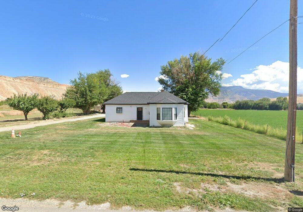
728 35 8/10 Rd Palisade, CO 81526
Palisade Area NeighborhoodEstimated Value: $670,000 - $854,000
4
Beds
3
Baths
3,134
Sq Ft
$231/Sq Ft
Est. Value
About This Home
This home is located at 728 35 8/10 Rd, Palisade, CO 81526 and is currently estimated at $724,872, approximately $231 per square foot. 728 35 8/10 Rd is a home located in Mesa County with nearby schools including Taylor Elementary School, Mount Garfield Middle School, and Palisade High School.
Ownership History
Date
Name
Owned For
Owner Type
Purchase Details
Closed on
Apr 21, 2021
Sold by
Slemon Judith K and The Slemon Separate Property T
Bought by
Watkins Thomas Freeman and Watkins Kristina Moria
Current Estimated Value
Purchase Details
Closed on
Nov 20, 2003
Sold by
Slemon Judith K
Bought by
Slemon Judith K and The Slemon Separate Property Trust
Purchase Details
Closed on
Dec 15, 1999
Sold by
Roskowski Philip M
Bought by
Slemon Judith K
Home Financials for this Owner
Home Financials are based on the most recent Mortgage that was taken out on this home.
Original Mortgage
$138,400
Interest Rate
7.69%
Purchase Details
Closed on
Nov 6, 1989
Sold by
Severyn Ruby O
Bought by
Slemon Separate Property Trust
Purchase Details
Closed on
Aug 15, 1989
Sold by
Severyn Roger D
Bought by
Slemon Separate Property Trust
Create a Home Valuation Report for This Property
The Home Valuation Report is an in-depth analysis detailing your home's value as well as a comparison with similar homes in the area
Home Values in the Area
Average Home Value in this Area
Purchase History
| Date | Buyer | Sale Price | Title Company |
|---|---|---|---|
| Watkins Thomas Freeman | $505,000 | Land Title Guarantee Co | |
| Slemon Judith K | -- | -- | |
| Slemon Judith K | $199,900 | -- | |
| Slemon Separate Property Trust | $64,000 | -- | |
| Slemon Separate Property Trust | -- | -- |
Source: Public Records
Mortgage History
| Date | Status | Borrower | Loan Amount |
|---|---|---|---|
| Previous Owner | Slemon Judith K | $138,400 |
Source: Public Records
Tax History Compared to Growth
Tax History
| Year | Tax Paid | Tax Assessment Tax Assessment Total Assessment is a certain percentage of the fair market value that is determined by local assessors to be the total taxable value of land and additions on the property. | Land | Improvement |
|---|---|---|---|---|
| 2024 | $2,748 | $36,290 | $3,380 | $32,910 |
| 2023 | $2,748 | $36,290 | $3,380 | $32,910 |
| 2022 | $1,427 | $16,810 | $2,630 | $14,180 |
| 2021 | $1,125 | $12,850 | $2,890 | $9,960 |
| 2020 | $966 | $10,780 | $2,320 | $8,460 |
| 2019 | $925 | $10,780 | $2,320 | $8,460 |
| 2018 | $1,007 | $10,980 | $3,060 | $7,920 |
| 2017 | $979 | $10,980 | $3,060 | $7,920 |
| 2016 | $826 | $9,880 | $2,480 | $7,400 |
| 2015 | $834 | $9,880 | $2,480 | $7,400 |
| 2014 | $711 | $7,960 | $1,770 | $6,190 |
Source: Public Records
Map
Nearby Homes
- 733 35 6 10 Rd
- 707 36 3 10 Rd
- 759 36 3 10 Rd
- 3603 Grand Valley Canal Rd
- 3652 1/2 G 7 10 Rd
- 3669 G Rd
- 822 Cabernet Ct
- 745 Fairhaven Rd
- 602 Elberta Ave
- 548 Crawford Ln
- 537 Crawford Ln
- 532 Crawford Ln
- 577 Cicero Dr
- 819 Elberta Ave
- 549 Cicero Dr
- 512 Crawford Ln
- 846 Cabernet Dr
- 828 Logan Ct
- 829 Logan St
- 490 Wine Valley Rd