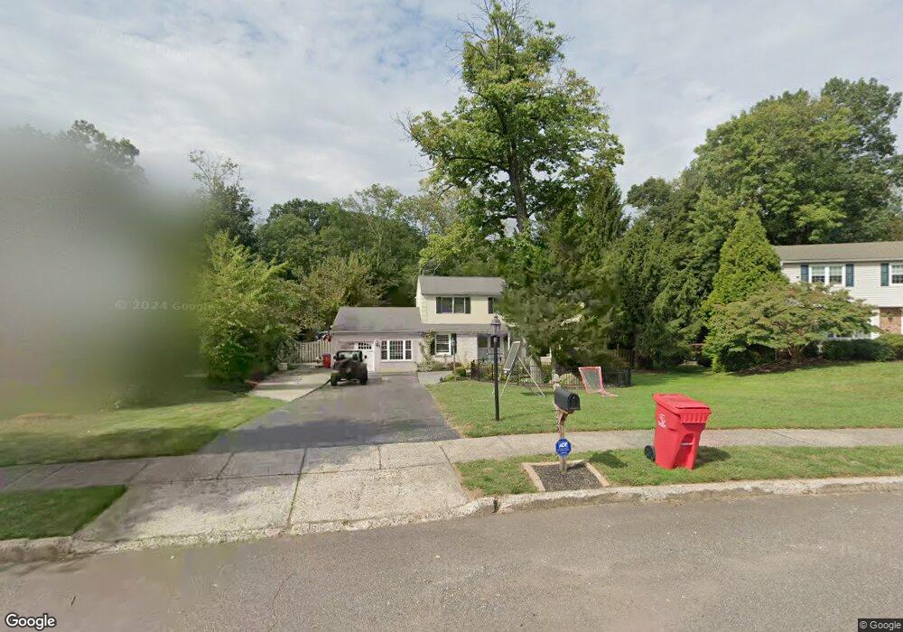
728 Mourning Dove Rd Norristown, PA 19403
Estimated Value: $589,000 - $691,000
4
Beds
3
Baths
2,920
Sq Ft
$216/Sq Ft
Est. Value
About This Home
This home is located at 728 Mourning Dove Rd, Norristown, PA 19403 and is currently estimated at $630,811, approximately $216 per square foot. 728 Mourning Dove Rd is a home located in Montgomery County with nearby schools including Woodland Elementary School, Skyview Upper Elementary School, and Arcola Intermediate School.
Ownership History
Date
Name
Owned For
Owner Type
Purchase Details
Closed on
Sep 30, 2005
Sold by
Paschall Barbara D
Bought by
Huff Christopher M and Huff Stacey M
Current Estimated Value
Home Financials for this Owner
Home Financials are based on the most recent Mortgage that was taken out on this home.
Original Mortgage
$25,000
Outstanding Balance
$13,398
Interest Rate
5.78%
Estimated Equity
$617,413
Purchase Details
Closed on
Jan 5, 1998
Sold by
Paschall Anthony M and Paschall Barbara D
Bought by
Paschall Barbara D
Create a Home Valuation Report for This Property
The Home Valuation Report is an in-depth analysis detailing your home's value as well as a comparison with similar homes in the area
Home Values in the Area
Average Home Value in this Area
Purchase History
| Date | Buyer | Sale Price | Title Company |
|---|---|---|---|
| Huff Christopher M | $370,000 | -- | |
| Paschall Barbara D | -- | -- |
Source: Public Records
Mortgage History
| Date | Status | Borrower | Loan Amount |
|---|---|---|---|
| Open | Huff Christopher M | $25,000 | |
| Open | Huff Christopher M | $296,000 |
Source: Public Records
Tax History Compared to Growth
Tax History
| Year | Tax Paid | Tax Assessment Tax Assessment Total Assessment is a certain percentage of the fair market value that is determined by local assessors to be the total taxable value of land and additions on the property. | Land | Improvement |
|---|---|---|---|---|
| 2025 | $8,009 | $196,350 | $52,840 | $143,510 |
| 2024 | $8,009 | $196,350 | $52,840 | $143,510 |
| 2023 | $7,705 | $196,350 | $52,840 | $143,510 |
| 2022 | $7,494 | $196,350 | $52,840 | $143,510 |
| 2021 | $7,301 | $196,350 | $52,840 | $143,510 |
| 2020 | $7,130 | $196,350 | $52,840 | $143,510 |
| 2019 | $7,064 | $196,350 | $52,840 | $143,510 |
| 2018 | $7,065 | $196,350 | $52,840 | $143,510 |
| 2017 | $6,746 | $196,350 | $52,840 | $143,510 |
| 2016 | $6,669 | $196,350 | $52,840 | $143,510 |
| 2015 | $6,410 | $196,350 | $52,840 | $143,510 |
| 2014 | $6,410 | $196,350 | $52,840 | $143,510 |
Source: Public Records
Map
Nearby Homes
- 617 Meadowlark Rd
- 3026 Highley Rd
- 1102 Redtail Rd
- 35 Buckwalter Rd
- LOT 24 Egypt Rd
- 2825 Egypt Rd
- 123 Glenwood Ave
- 106 Glenwood Ave
- 636 Hillside Ave
- 18 Pheasant Rd
- 2016 Bayless Place Unit CONDO Q-4
- 308 Hillside Ave
- Laney Craftsman
- 11 Pershing Ave
- 0 Roosevelt Blvd
- 11 Wilson Blvd
- 12 Wilson Blvd
- 38 S Grange Ave
- 2044 Mill Rd
- 109 N Park Ave
- 732 Mourning Dove Rd
- 724 Mourning Dove Rd
- 736 Mourning Dove Rd
- 720 Mourning Dove Rd
- 717 Mourning Dove Rd
- 721 Mourning Dove Rd
- 861 Mourning Dove Rd
- 716 Mourning Dove Rd
- 713 Mourning Dove Rd
- 852 Mourning Dove Rd
- 857 Mourning Dove Rd
- 709 Mourning Dove Rd Unit 35
- 725 Mockingbird Ln
- 721 Mockingbird Ln
- 848 Mourning Dove Rd
- 729 Mockingbird Ln
- 717 Mockingbird Ln
- 902 Sunnyside Ave
- 708 Mourning Dove Rd
- 853 Mourning Dove Rd