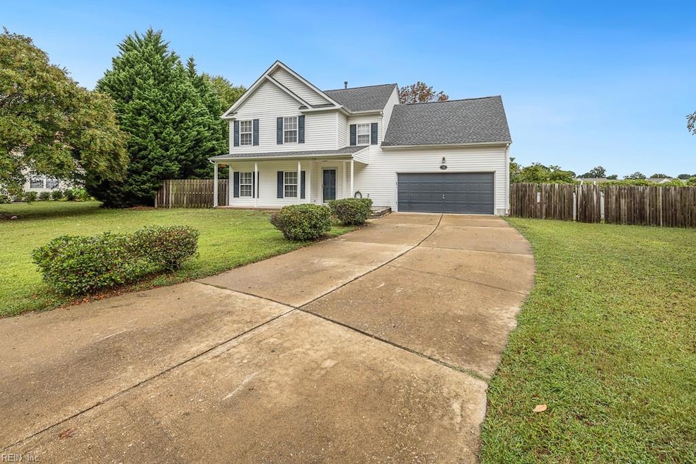
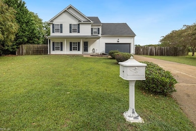
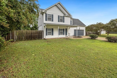
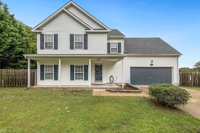
728 W Andrews Crossing Smithfield, VA 23430
Estimated payment $2,575/month
Highlights
- Above Ground Pool
- Traditional Architecture
- No HOA
- Finished Room Over Garage
- Attic
- Utility Closet
About This Home
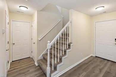
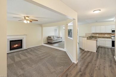
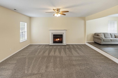
Welcome to John Rolfe Estates! This beautiful 4-bedroom, 2.5-bath home offers nearly 1,900 sq. ft. of comfortable living space in one of Smithfield’s most sought-after neighborhoods. The inviting floor plan features a spacious living area, open kitchen for everyday living or entertaining. Upstairs you’ll find generously sized bedrooms, including a primary suite with a private bath. Enjoy the outdoors with a fully fenced backyard—for pets, kids, or weekend gatherings. Conveniently located near schools, shopping, and historic downtown Smithfield, this home blends neighborhood charm with modern convenience.
Home Details
Home Type
- Single Family
Est. Annual Taxes
- $2,477
Year Built
- Built in 2002
Lot Details
- Cul-De-Sac
- Wood Fence
- Chain Link Fence
- Property is zoned TOWN
Home Design
- Traditional Architecture
- Slab Foundation
- Asphalt Shingled Roof
- Vinyl Siding
Interior Spaces
- 1,890 Sq Ft Home
- 2-Story Property
- Ceiling Fan
- Gas Fireplace
- Utility Closet
- Washer and Dryer Hookup
- Scuttle Attic Hole
Kitchen
- Electric Range
- Microwave
- Dishwasher
- Disposal
Flooring
- Carpet
- Laminate
- Vinyl
Bedrooms and Bathrooms
- 4 Bedrooms
- En-Suite Primary Bedroom
- Walk-In Closet
Parking
- 2 Car Attached Garage
- Finished Room Over Garage
- Off-Street Parking
Outdoor Features
- Above Ground Pool
- Porch
Schools
- Hardy Elementary School
- Smithfield Middle School
- Smithfield High School
Utilities
- Central Air
- Heat Pump System
- Gas Water Heater
- Cable TV Available
Community Details
- No Home Owners Association
- All Others Area 64 Subdivision
Map
Home Values in the Area
Average Home Value in this Area
Tax History
| Year | Tax Paid | Tax Assessment Tax Assessment Total Assessment is a certain percentage of the fair market value that is determined by local assessors to be the total taxable value of land and additions on the property. | Land | Improvement |
|---|---|---|---|---|
| 2025 | $2,572 | $331,900 | $50,000 | $281,900 |
| 2024 | $2,423 | $331,900 | $50,000 | $281,900 |
| 2023 | $2,411 | $331,900 | $50,000 | $281,900 |
| 2022 | $2,137 | $245,100 | $50,000 | $195,100 |
| 2021 | $2,137 | $245,100 | $50,000 | $195,100 |
| 2020 | $2,137 | $245,100 | $50,000 | $195,100 |
| 2019 | $2,137 | $245,100 | $50,000 | $195,100 |
| 2018 | $1,314 | $242,400 | $50,000 | $192,400 |
| 2016 | $2,132 | $242,400 | $50,000 | $192,400 |
| 2015 | $2,056 | $242,400 | $50,000 | $192,400 |
| 2014 | $2,056 | $233,900 | $50,000 | $183,900 |
| 2013 | $1,520 | $233,900 | $50,000 | $183,900 |
Property History
| Date | Event | Price | List to Sale | Price per Sq Ft |
|---|---|---|---|---|
| 11/11/2025 11/11/25 | Price Changed | $448,499 | 0.0% | $237 / Sq Ft |
| 10/24/2025 10/24/25 | Price Changed | $448,500 | -0.1% | $237 / Sq Ft |
| 09/19/2025 09/19/25 | For Sale | $449,000 | -- | $238 / Sq Ft |
Purchase History
| Date | Type | Sale Price | Title Company |
|---|---|---|---|
| Deed | $349,250 | New Title Company Name | |
| Deed | $151,000 | -- | |
| Deed | $265,500 | -- |
Mortgage History
| Date | Status | Loan Amount | Loan Type |
|---|---|---|---|
| Open | $279,400 | New Conventional |
Source: Real Estate Information Network (REIN)
MLS Number: 10601154
APN: 22Q-01-011
Disclaimer: Certain information contained herein is derived from information provided by parties other than Homes.com. All information provided is deemed reliable, but is not guaranteed to be accurate and should be independently verified.
![]() The listings data displayed on this medium comes in part from the Real Estate Information Network, Inc. (REIN) and has been authorized by participating listing Broker Members of REIN for display. REIN's listings are based upon Data submitted by its Broker Members, and REIN therefore makes no representation or warranty regarding the accuracy of the Data. All users of REIN's listings database should confirm the accuracy of the listing information directly with the listing agent.
The listings data displayed on this medium comes in part from the Real Estate Information Network, Inc. (REIN) and has been authorized by participating listing Broker Members of REIN for display. REIN's listings are based upon Data submitted by its Broker Members, and REIN therefore makes no representation or warranty regarding the accuracy of the Data. All users of REIN's listings database should confirm the accuracy of the listing information directly with the listing agent.
Copyright 2025 REIN. REIN's listings Data and information is protected under federal copyright laws. Federal law prohibits, among other acts, the unauthorized copying or alteration of, or preparation of derivative works from, all or any part of copyrighted materials, including certain compilations of Data and information. COPYRIGHT VIOLATORS MAY BE SUBJECT TO SEVERE FINES AND PENALTIES UNDER FEDERAL LAW.
REIN updates its listings on a daily basis.
Some listings may be duplicated in the search results due to the co-mingling of listings from more than one multiple listing service. Should there be different listing information between the duplicated listings; user is advised to verify the accuracy of the listing information before making any financial decisions.
Some or all of the listings (or listings Data) represented in this application have been enhanced with Data not provided by REIN. The enhancements are as follows: mapping, demographics, and economics. The source of these enhancements are: GreatSchools, CoStar, Google, Walk Score, How Loud, Collateral Analytics, Black Knight, First American, and Quantarium.
This application does not include information on all of the properties available for sale at this time.
- 200 Oxford Ave Unit 46-2
- 202 Oxford Ave Unit 46-1
- 210 Oxford Ave Unit 47-1
- 104 Cathedral St
- 104 Cathedral St Unit 39-1
- 105 Cathedral St
- Newport - Villa Home, Church Square Plan at Church Square
- Augusta - Villa Home, Church Square Plan at Church Square
- Newport w/ Loft - Villa Home, Church Square Plan at Church Square
- Augusta w/ Loft Level - Villa Home, Church Square Plan at Church Square
- Windsor - Villa Home, Church Square Plan at Church Square
- 901 S Church St
- 202 Saint Paul's Ave Unit 29-2
- 224 Saint Paul's Ave Unit 32-3
- 224 St Pauls Ave
- 304 Cathedral St
- 222 Richmond Ave Unit 20-1
- 222 Richmond Ave
- 928 Pocahontas Ct
- 804 S Church St
- 982 John Rolfe Dr
- 701 Lakeview Cove
- 409 Southampton Ct
- 364 Main St
- 303 1st St
- 100 Cattail Ln
- 513 Main St
- 889 W Main St
- 8812 Smithfield Ln Unit 17
- 347 Spring Hill Place
- 135 Spring Meadow Ln
- 1610 Havenstreet Cir
- 100 Top Deck Way
- 303 Blue Heron Trail
- 16101 Carrollton Blvd
- 13648 Track Ln
- 509 Frank Ln
- 218 Crittenden Ln
- 246 Barclay Rd
- 662 Deep Creek Rd
