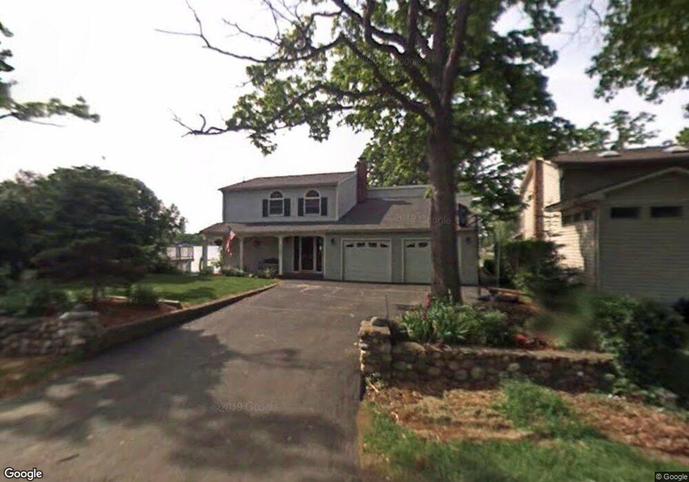
7283 Andersonville Rd Clarkston, MI 48346
Estimated Value: $484,000 - $568,000
--
Bed
1
Bath
1,932
Sq Ft
$276/Sq Ft
Est. Value
About This Home
This home is located at 7283 Andersonville Rd, Clarkston, MI 48346 and is currently estimated at $533,186, approximately $275 per square foot. 7283 Andersonville Rd is a home located in Oakland County with nearby schools including Andersonville Elementary School, Our Lady Of The Lakes Catholic School, and Waterford Montessori Academy - Midland.
Ownership History
Date
Name
Owned For
Owner Type
Purchase Details
Closed on
Sep 28, 2000
Sold by
Bernek Kenneth R
Bought by
Featherston Robert C
Current Estimated Value
Purchase Details
Closed on
Mar 28, 1996
Sold by
Garrett Grant G
Bought by
Bernek Kenneth R
Home Financials for this Owner
Home Financials are based on the most recent Mortgage that was taken out on this home.
Original Mortgage
$210,350
Interest Rate
7.91%
Create a Home Valuation Report for This Property
The Home Valuation Report is an in-depth analysis detailing your home's value as well as a comparison with similar homes in the area
Home Values in the Area
Average Home Value in this Area
Purchase History
| Date | Buyer | Sale Price | Title Company |
|---|---|---|---|
| Featherston Robert C | $280,000 | -- | |
| Bernek Kenneth R | $247,500 | -- |
Source: Public Records
Mortgage History
| Date | Status | Borrower | Loan Amount |
|---|---|---|---|
| Previous Owner | Bernek Kenneth R | $210,350 | |
| Closed | Featherston Robert C | -- |
Source: Public Records
Tax History Compared to Growth
Tax History
| Year | Tax Paid | Tax Assessment Tax Assessment Total Assessment is a certain percentage of the fair market value that is determined by local assessors to be the total taxable value of land and additions on the property. | Land | Improvement |
|---|---|---|---|---|
| 2024 | $2,710 | $237,400 | $64,000 | $173,400 |
| 2023 | $3,654 | $216,600 | $60,600 | $156,000 |
| 2022 | $4,748 | $206,300 | $60,600 | $145,700 |
| 2021 | $4,795 | $172,700 | $40,400 | $132,300 |
| 2020 | $2,366 | $155,700 | $39,400 | $116,300 |
| 2018 | $5,321 | $138,500 | $20,400 | $118,100 |
| 2015 | -- | $114,400 | $0 | $0 |
| 2014 | -- | $108,600 | $0 | $0 |
| 2011 | -- | $92,900 | $0 | $0 |
Source: Public Records
Map
Nearby Homes
- 7490 Andersonville Rd
- 5021 Paula Ave
- 6689 Andersonville Rd
- 4475 N Meadow Dr
- 6685 Windiate Rd
- 6629 Andersonville Rd Unit A8
- 6723 Andersonville Rd Unit E42
- 00 Blain Island
- 4619 Curtis Ln
- 4602 Curtis Ln
- 4123 Windiate Park Dr
- 7849 Twins Dr Unit 4
- 3940 Maiden St
- 3853 Dorothy Ln
- 6570 Saline Dr
- 6533 Cloverton Dr
- 6788 Balmoral Terrace
- 6624 Wellesley Terrace
- 3880 Lotus Dr
- 5690 White Lake Rd
- 7295 Andersonville Rd
- 7275 Andersonville Rd
- 7305 Andersonville Rd
- 7257 Andersonville Rd
- 7276 Andersonville Rd
- 7266 Andersonville Rd
- 7286 Andersonville Rd
- 7256 Andersonville Rd
- 7238 Andersonville Rd
- 7244 Andersonville Rd
- 7296 Andersonville Rd
- 7230 Andersonville Rd
- 7224 Andersonville Rd
- 7431 Lake Forest Dr
- 7217 Andersonville Rd
- 7421 Lake Forest Dr Unit 2
- 7215 Andersonville Rd
- 7411 Lake Forest Dr
- 7211 Lake Ln
- VAC Clement