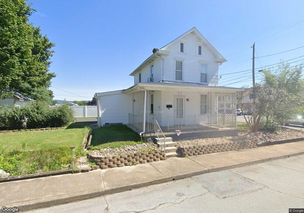
729 Maple St Unit 1 Waynesboro, PA 17268
Estimated Value: $118,776 - $177,000
--
Bed
1
Bath
963
Sq Ft
$143/Sq Ft
Est. Value
About This Home
This home is located at 729 Maple St Unit 1, Waynesboro, PA 17268 and is currently estimated at $137,444, approximately $142 per square foot. 729 Maple St Unit 1 is a home located in Franklin County with nearby schools including Waynesboro Area Senior High School, Noah's Ark Christian Child Care Center, and St. Andrew Catholic School.
Ownership History
Date
Name
Owned For
Owner Type
Purchase Details
Closed on
Aug 17, 2022
Sold by
Knepper Properties Llc
Bought by
Wellspring Real Estate Llc
Current Estimated Value
Purchase Details
Closed on
Sep 16, 2016
Sold by
Fannie Mae
Bought by
Knepper Properties Llc
Home Financials for this Owner
Home Financials are based on the most recent Mortgage that was taken out on this home.
Original Mortgage
$33,750
Interest Rate
3.43%
Mortgage Type
New Conventional
Purchase Details
Closed on
Apr 14, 2016
Sold by
Cronin Sonia E
Bought by
Federal National Mortgage Association
Create a Home Valuation Report for This Property
The Home Valuation Report is an in-depth analysis detailing your home's value as well as a comparison with similar homes in the area
Home Values in the Area
Average Home Value in this Area
Purchase History
| Date | Buyer | Sale Price | Title Company |
|---|---|---|---|
| Wellspring Real Estate Llc | $1,135,000 | Pa Real Estate Settlement Serv | |
| Knepper Properties Llc | $45,000 | Attorney | |
| Federal National Mortgage Association | -- | Attorney |
Source: Public Records
Mortgage History
| Date | Status | Borrower | Loan Amount |
|---|---|---|---|
| Previous Owner | Knepper Properties Llc | $33,750 |
Source: Public Records
Tax History Compared to Growth
Tax History
| Year | Tax Paid | Tax Assessment Tax Assessment Total Assessment is a certain percentage of the fair market value that is determined by local assessors to be the total taxable value of land and additions on the property. | Land | Improvement |
|---|---|---|---|---|
| 2025 | $1,280 | $7,060 | $980 | $6,080 |
| 2024 | $1,092 | $6,180 | $980 | $5,200 |
| 2023 | $1,068 | $6,180 | $980 | $5,200 |
| 2022 | $1,034 | $6,180 | $980 | $5,200 |
| 2021 | $982 | $6,180 | $980 | $5,200 |
| 2020 | $974 | $6,180 | $980 | $5,200 |
| 2019 | $955 | $6,180 | $980 | $5,200 |
| 2018 | $901 | $6,180 | $980 | $5,200 |
| 2017 | $884 | $6,180 | $980 | $5,200 |
| 2016 | $177 | $6,180 | $980 | $5,200 |
| 2015 | $165 | $6,180 | $980 | $5,200 |
| 2014 | $165 | $6,180 | $980 | $5,200 |
Source: Public Records
Map
Nearby Homes
- 824 S Church St
- 911 Park St
- 27 W 6th St
- 305 W 7th St
- 511 Hamilton Ave
- 118 W 5th St
- 202 W 5th St
- 313 Park St
- 417 Fairview Ave
- 462 Scott Ave Unit 4
- 208 Hamilton Ave
- 220 Cleveland Ave
- 223 E 3rd St
- Fulton I Plan at Brimington Farm
- Bristol III Plan at Brimington Farm - Brimington
- Hanover Plan at Brimington Farm - Brimington
- Montgomery Plan at Brimington Farm
- Franklin Plan at Brimington Farm
- Erie Plan at Brimington Farm
- 430 Abigail Ave