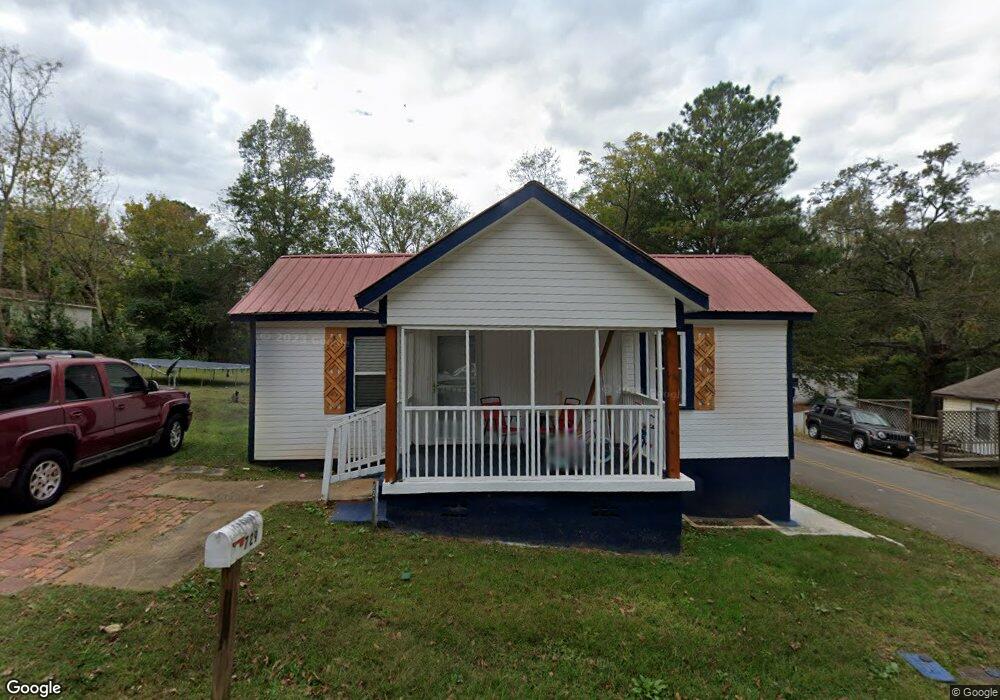
729 Martin Luther King jr Dr Manchester, GA 31816
Estimated Value: $64,613 - $88,000
3
Beds
1
Bath
957
Sq Ft
$81/Sq Ft
Est. Value
About This Home
This home is located at 729 Martin Luther King jr Dr, Manchester, GA 31816 and is currently estimated at $77,653, approximately $81 per square foot. 729 Martin Luther King jr Dr is a home located in Meriwether County with nearby schools including Mountain View Elementary School, Manchester Middle School, and Manchester High School.
Ownership History
Date
Name
Owned For
Owner Type
Purchase Details
Closed on
Apr 9, 2021
Sold by
Howard Brenda A
Bought by
Lowe Tameka and Howard Brenda A
Current Estimated Value
Purchase Details
Closed on
Jun 26, 2014
Sold by
Anderson Roger
Bought by
Anderson Brenda L
Purchase Details
Closed on
Feb 11, 2011
Sold by
Coleman Michelle Vanessa
Bought by
Anderson Roger
Purchase Details
Closed on
Jul 3, 2007
Sold by
Not Provided
Bought by
Anderson Roger
Purchase Details
Closed on
Jan 1, 1947
Bought by
Smith Lizzie
Create a Home Valuation Report for This Property
The Home Valuation Report is an in-depth analysis detailing your home's value as well as a comparison with similar homes in the area
Home Values in the Area
Average Home Value in this Area
Purchase History
| Date | Buyer | Sale Price | Title Company |
|---|---|---|---|
| Lowe Tameka | -- | -- | |
| Anderson Brenda L | -- | -- | |
| Anderson Roger | $2,354 | -- | |
| Anderson Roger | $2,354 | -- | |
| Anderson Roger | -- | -- | |
| Smith Lizzie | -- | -- |
Source: Public Records
Tax History Compared to Growth
Tax History
| Year | Tax Paid | Tax Assessment Tax Assessment Total Assessment is a certain percentage of the fair market value that is determined by local assessors to be the total taxable value of land and additions on the property. | Land | Improvement |
|---|---|---|---|---|
| 2024 | $60 | $1,280 | $520 | $760 |
| 2023 | $62 | $1,280 | $520 | $760 |
| 2022 | $62 | $1,280 | $520 | $760 |
| 2021 | $41 | $1,280 | $520 | $760 |
| 2020 | $41 | $1,280 | $520 | $760 |
| 2019 | $41 | $1,280 | $520 | $760 |
| 2018 | $42 | $1,280 | $520 | $760 |
| 2017 | $42 | $1,280 | $520 | $760 |
| 2016 | $42 | $1,280 | $520 | $760 |
| 2015 | $42 | $1,280 | $520 | $760 |
Source: Public Records
Map
Nearby Homes
- 322 Chalybeate St
- 77 Cordwood St
- 802 Jd Parham Dr
- 305 Holy Hill Place
- 200 Hunt Cir
- 603 Atlantic St
- 919 L S Glencamp Way
- 94 Cato St
- 13.27 ACRES Roosevelt Hwy
- 12 Truitt St
- 0 Phil Howe Rd Unit 10494213
- 16 North St
- 21 North St
- 522 4th St
- 304 4th St
- 36 E 2nd St
- 408 Broad St
- 514 Farris Blvd
- 434 Parkman Dr
- 604 Farris Blvd
- 801 Martin Luther King jr Dr
- 730 Oconee St
- 723 Martin Luther King jr Dr
- 728 Oconee St
- 722 Martin Luther King jr Dr
- 804 Martin Luther King jr Dr
- 718 Martin Luther King jr Dr
- 729 Oconee St
- 52 King St
- 720 Oconee St
- 723 Oconee St
- 13 King St
- 717 Martin Luther King jr Dr
- 721 Oconee St
- 725 Max Anderson Dr
- 723 Max Anderson Dr
- 721 Max Anderson Dr
- 716 Oconee St
- 0 King St Unit 7000017
- 0 King St Unit 8133999